Balbharti Maharashtra State Board Class 6 Science Solutions Chapter 14 Light and the Formation of Shadows Notes, Textbook Exercise Important Questions and Answers.
Std 6 Science Chapter 14 Light and the Formation of Shadows Question Answer Maharashtra Board
Class 6 Science Chapter 14 Light and the Formation of Shadows Question Answer Maharashtra Board
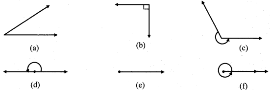
1. Choose an appropriate word and fill in the blanks.
Question a.
A ……………. is a natural source of light.
Answer:
star
![]()
Question b.
A ………….. is an artificial source of light.
Answer:
candle
Question c.
When light passes through a prism, it gets separated into ………….. colours.
Answer:
seven
Question d.
The image obtained in the pinhole camera is …………. .
Answer:
inverted
Question e.
A shadow is formed when an …………… object comes in the way of light.
Answer:
opaque
![]()
Question f.
When a ………….. object comes in the way of light, light passes …………… it. options : seven, star, through, transparent, opaque, colors, shape, erect, inverted, luminous, candle.
Answer:
transparent, through
2. Write whether the following objects are luminous or non-luminous.
Question a.
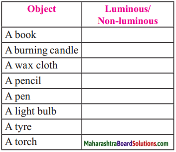
Answer:
| Object | Luminous /Non-luminous |
| A book | Non-luminous |
| A burning candle | Luminous |
| A wax cloth | Non-luminous |
| A pencil | Non-luminous |
| A pen | Non-luminous |
| A light bulb | Luminous |
| A tyre | Non-luminous |
| A torch | Luminous |
| Stars | Luminous |
| The planets | Non-luminous |
| A satellite | Non-luminous |
| The Moon | Non-luminous |
3. Match the following.
Question a.
| Natural sources of light | Man-made sources of light |
| The Sun | Tubelight |
| Stars in the night sky | Light bulb |
| Fireflies | Torch |
| Anglerfish | Burning candle |
| Honey mushroom | Oil lamps |
Answer:
| Transparent | Opaque | Translucent |
| Piece of glass Water | White plastic Tea kettle Note book Cloth Wooden cupboard |
Tinted glass Oil paper Sheet of notebook Wax paper |
4. Write the answers to the following.
Question a.
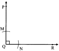
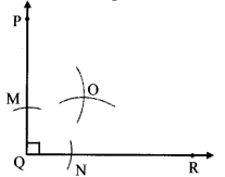
What things are necessary for the formation of a shadow?
Answer:
Things necessary for the formation of a shadow are:
- A source of light
- An object
- A surface or screen on which the shadow is formed
![]()
Question b.
When can an object be seen?
Answer:
We can see an object when reflected rays reach our eyes.
Question c.
What is a shadow?
Answer:
- If an opaque object comes in the way of a light source, light does not pass through it.
- As a result the light does not reach a wall or any other surface on the other side of the object.
- That part remains dark. This dark part is called the shadow of the object.
Project:
Question 1.
Prepare a Newton’s disc.
Question 2.
Find out how to save electricity with the help of the sunlight we receive during the day.
![]()
Question 3.
Read a biography of Sir C. V. Raman and find out about the discoveries he made.
Class 6 Science Chapter 14 Light and the Formation of Shadows Important Questions and Answers
Fill in the blanks.
Question 1.
The ……………. is the main natural source of light.
Answer:
Sun
Question 2.
The light emitted by an electric torch is more …………….. than that obtained from a candle.
Answer:
intense
Question 3.
The left and right sides of the original object appear to be …………….. in the mirror.
Answer:
exchanged
Question 4.
The image is as far behind the mirror as the object is in ……………… of it.
Answer:
front
![]()
Question 5.
The …………….. of the image is the same as that of the object.
Answer:
height
Question 6.
The materials through which light passes is said to be …………… .
Answer:
transparent
Question 7.
The materials through which light does not pass is said to be ………….. .
Answer:
opaque
Question 8.
The materials through which light passes partially is said to be ………….. .
Answer:
translucent
Question 9.
If an ………….. object comes in the way of a light source, light does not pass it.
Answer:
opaque, through
![]()
Question 10.
The shadow of an object formed due to sunlight is ………….. in the mornings and evenings and ……………. in the afternoon.
Answer:
long, short
Question 11.
The shadow of an object is formed only when ………….. does not pass through the object.
Answer:
light
Question 12.
Stars are ………….. .
Answer:
luminous
Question 13.
Planets, satellites are ………….. .
Answer:
non-luminous
Question 14.
The largest sundial is at ………….., New Delhi.
Answer:
Jantar Mantar
Question 15.
………….. is celebrated as National Science Day.
Answer:
28th February
![]()
Question 16.
Light travels in a straight line. This is called ………….. .
Answer:
linear propagation of light
Question 17.
The image formed on the diaphragm of the pinhole camera is ………….. .
Answer:
inverted
Question 18.
The kind of shadow an object forms depends upon the ………….. between the ………….., the object and the ………….. or the ………….. on which the shadow is formed.
Answer:
relative distance, source of light, surface, screen
State whether following statements are True or False.
Question 1.
Light travels in a straight line.
Answer:
True
![]()
Question 2.
Stars are luminous.
Answer:
True
Question 3.
Image in a pinhole camera is inverted.
Answer:
True
Question 4.
In the afternoon, shadows are long.
Answer:
False
Question 5.
Fireflies are a natural source of light.
Answer:
True
Question 6.
We see the candle clearly when we bend the tube.
Answer:
False
Question 7.
We can see our image clearly in running water.
Answer:
False
![]()
Question 8.
Tracing paper is transparent.
Answer:
False
Question 9.
The light obtained from an electric torch is more intense than that obtained from a candle.
Answer:
True
Question 10.
28tn February is celebrated as “National Science day” since 1987 in India.
Answer:
True
Question 11.
Classify the following into natural and man-made/artificial sources of light. (tubelight, light bulb, torch, burning candle, the sun, fireflies, anglerfish, honey mushroom, stars in the night sky, oil lamps, lanterns)
Answer:
| Natural sources of light | Man-made sources of light |
| The Sun Stars in the night sky Fireflies Anglerfish Honey mushroom |
Tubelight Light bulb Torch Burning candle Oil lamps Lanterns |
![]()
Question 12.
Identify the transparent, opaque and translucent objects from among the following. (piece of glass, wax paper, tinted glass, oil paper, white plastic, a tea kettle, a notebook, cloth, water, a wooden cupboard, sheet of notebook.)
Answer:
| Transparent | Opaque | Translucent |
| Piece of glass Water |
White plastic Tea kettle Notebook Cloth Wooden cupboard |
Tinted glass Oil-paper Sheet of notebook Wax paper |
Question 13.
Classify the following into the type of images they form: Clear image, faint image, no image. (still clear water, cemented wall, wooden surface, new steel dish, flower, glossy granite cladding of a wall, mirror, butter paper).
Answer:
| Clear Image | Faint Image | No Image |
| Still clear water, New steel dish, Glossy granite cladding of a wall, Mirror |
Butter paper | Wooden surface Flower Cemented wall |
Question 14.
Relate images formed with the surfaces.
Answer:
- The clear images are formed on plane surfaces.
- Faint or no images are formed on rough surfaces.
Answer in one sentence.
Question 1.
What are luminous objects?
Answer:
The objects which emit light i.e. which themselves are a source of light, are called luminous objects.
![]()
Question 2.
What determines the intensity of light?
Answer:
The intensity of light is determined by the extent to which the objects emit light.
Question 3.
What are non-luminous objects?
Answer:
The objects that are not sources of light themselves are called as non-luminous objects.
Question 4.
What are artificial sources of light?
Answer:
Man-made objects which emit light are artificial sources of light.
Question 5.
What are natural sources of light?
Answer:
Natural substances, materials which emit light are called natural sources of light.
Question 6.
What is linear propagation of light?
Answer:
Property of light travelling in a straight line is linear propagation of light.
![]()
Question 7.
What is reflection of light?
Answer:
The rays of light falling on an object from a source of light are thrown back from the substance of that object. This is reflection of light.
Question 8.
How do we see objects around us?
Answer:
The rays of light falling on an object from a source of light are thrown back from the surface of that object. This is called reflection of light. We see the object when the reflected rays reach our eyes.
Question 9.
What is moonlight?
Answer:
Sunlight reflected from the surface of the moon reaching us, in which we see the moon is called the moonlight.
Question 10.
What type of image is formed in the mirror?
Answer:
The image formed in the mirror is ‘laterally inverted’ i.e. right side appears as left side and left side appears as right side.
Question 11.
What change do you see in the image if you decrease or increase your distance from the mirror?
Answer:
When the distance between object and mirror is increased the size of image decreases where as, when the distance is decreased the image size increases.
![]()
Question 12.
What difference do you find in the height of the image in the mirror and yourself?
Answer:
The size of the image in the mirror is the same as that of the object.
Question 13.
What is the image on the diaphragm of the pinhole camera?
Answer:
An inverted or an upside down image of the candle is seen on the diaphragm of the pinhole camera.
Question 14.
What do you mean by transparent object?
Answer:
The objects / materials through which light passes are said to be transparent.
Question 15.
What do you mean by opaque materials?
Answer:
The materials through which light does not pass are said to be opaque.
Question 16.
What do you mean by translucent materials?
Answer:
The materials through which light passes partially are said to be translucent.
![]()
Question 17.
How is the shadow in the morning, afternoon and evening?
Answer:
The shadows are long in the mornings and evenings and short in the afternoon.
Question 18.
What is shade of a tree?
Answer:
The shade of a tree is its shadow.
Question 19.
How many colours is sunlight made up of?
Answer:
Sunlight is made up of seven colours.
Give reasons for the following.
Question 1.
When we see in the mirror, we see our image in the mirror.
Answer:
When we see our face in the mirror, the light reflected from our face falls on the mirror and gets reflected back again. Hence, we see our image in the mirror.
![]()
Question 2.
Opaque materials cast shadow.
Answer:
An opaque material does not allow light to pass. Hence, it casts a shadow.
Question 3.
Transparent and translucent object do not cast a shadow.
Answer:
Translucent objects cast a faint shadow whereas transparent objects do not cast a shadow at all because they allow light to pass through them.
Use your brain power!
Question 1.
Why is the image on the diaphragm of the pinhole camera inverted?
Answer:
1. The pinhole camera works on the principle of light travelling in a straight line.
2. The rays of light from the candle flame go in all directions.
3. We consider only two rays that pass through the hole and fall on the screen.
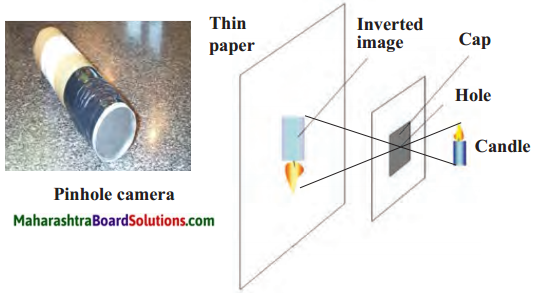
4. The rays intersect at the pinhole.
5. Since the rays cross over at that point, the top of the object appears at the bottom of the image and the bottom of the image appears at the top. Thus, we see an inverted image of the candle.
![]()
Question 2.
How will you light up a dark room using reflected light?
Answer:
Focusing on the wall with torch light. Mirrors or reflectors can be used to get light from outside.
Question 3.
Try to start the TV by operating the remote control from behind it.
Answer:
T.V will not start.
Question 4.
In which step is the flame of the candle seenclearly? Why?
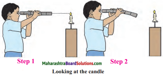
Answer:
In step 1 the flame of the candle is seen clearly because light travels in straight line.
Can you tell?
Question 1.
Can we see anything in total darkness?
Answer:
No, we cannot see anything in total darkness.
![]()
Question 2.
What helps us to see the objects around us?
Answer:
Reflected light helps us to see objects around us.
Question 3.
What does the light in each one of the pictures originate form?
Answer:
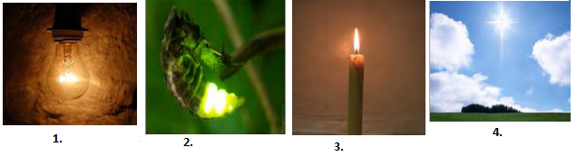
1. Bulb
2. Firefly
3. Candle
4. Sun
Question 4.
Name the natural sources of light.
Answer:
Sun, Fireflies
Question 5.
In which objects do we see our reflection?
Answer:
All objects reflect light rays, but the best reflectors of light are mirrors, still water in a lake, new steel dish i.e. smooth shiny surfaces.
![]()
Question 6.
What difference do you notice on looking through the windows in the picture? What causes the difference? The picture shows transperant, opaque, translucent window panes. Spot them.
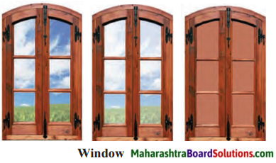
Answer:
- Through the first window we can see a clear picture of things outside.
- Second window gives a faint image.
- Through the third window, we can’t see anything
- The difference in the image is due to the material of the window panes.
- The first window pane is transparent.
- The second window pane is translucent.
- The third window pane is opaque.
Answer the following questions in brief.
Question 1.
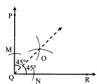
List factors on which shadow depends.
Answer:
Shadow depends on relative distance between the source of light, the object and the surface on which the shadow is formed.
Question 2.
How we can see that light travels in straight line.
Answer:
- In the morning or in the afternoon, rays of light enter a slit in a door, window or a small hole in the roof.
- As these rays of light from the slit or the hole move towards the floor, the dust particles in their way are clearly seen.
- Due to these particles, the path of light becomes visible to us.
- Thus we can see that their path is along straight lines.
![]()
Question 3.
What is the difference between an object and its reflection? What causes the difference?
Answer:
- Object and its reflection result in formation of images.
- Reflections taking place from highly polished metals, mirrors, still water etc, form clear images.
- Reflections taking place from wooden surface, flower, book form dull, blurred images.
- The difference in reflections is caused by the surface of the object.
- Regular reflections have smooth, polished surfaces, hence, image is clear.
- Diffused reflections have hard, rough surfaces, hence, image is dull.
Question 4.
List characteristics of images in a plane mirror.
Answer:
- The left and right sides of the original object appear to be exchanged in the mirror image.
- The image is as far behind the mirror as the object is in front of it.
- The size of the image is the same as that of the object.
Question 8.
State the characteristics of image formed by a pinhole camera.
Answer:
Characteristics of an image formed by a pinhole camera are as follows:
- It is inverted/upside down.
- It can be obtained on a screen – real image.
Try this.
Question 1.
Make your friend stand in between the torch and the wall. What happens?
Answer:
Friend’s Shadow forms on the wall.
![]()
Question 2.
Place a glass filled with water on a sheet of paper in the window so it receives direct sunlight. What is seen on the paper?
Answer:
We see rainbow colours on the paper.
Question 3.
Can we do the same in a dark room with the help of a prism and a torch? What do we learn from this?
Answer:
yes, we can. Light gets seperated into seven colour. From this we learn that white light contains seven colours.
Question 4.
If you dip the wire loop in the soap water and then blow it, soap bubbles are formed. Are the beautiful colours of the rainbow seen in these bubbles?
Answer:
Yes, splitting of white light into different colours takes place.
Question 5.
What do you see on holding a CD in the sun?
Answer:
CD reflects rainbow colours, and interesting : patterns.
![]()
Question 6.
Raise your right hand. In mirror which hand of the mirror image is raised?
Answer:
Left hand of the mirror image is raised.
Question 7.
Is there any difference between your height and height of the mirror image?
Answer:
The height remains the same.
6th Std Science Questions And Answers: