Std 12 Geography Chapter 4 Question Answer Primary Economic Activities Maharashtra Board
Balbharti Maharashtra State Board Class 12 Geography Solutions Chapter 4 Primary Economic Activities Textbook Exercise Questions and Answers.
Class 12 Geography Chapter 4 Primary Economic Activities Question Answer Maharashtra Board
Geography Class 12 Chapter 4 Question Answer Maharashtra Board
1. Choose the correct option and complete the sentence.
Question 1.
The gathering of various products from the forests for livelihood is mainly carried in
(a) Temperate coniferous forests.
(b) Temperate deciduous forests.
(c) Tropical deciduous forests.
(d) Equatorial evergreen forests.
Answer:
(d) Equatorial evergreen forests.
Question 2.
Ideal location for fishing
(a) rugged coasts, shallow seas, hot climate, growth of planktons.
(b) shallow seas, confluence of warm and cold ocean currents, growth of planktons, cold climate.
(c) continental shelf, growth of planktons, good fishing skills, cold climate.
(d) continental shelf, rugged coasts, growth of planktons, cold climate.
Answer:
(b) shallow seas, confluence of warm and cold ocean currents, growth of planktons, cold climate.
![]()
Question 3.
Primary economic activities not related directly to latitudinal locations
(a) lumbering
(b) fishing
(c) mining
(d) agriculture
Answer:
(c) mining
Question 4.
Characteristics of extensive commercial agriculture
(a) monoculture, use of water, tropical, cereal production.
(b) monoculture, use of machinery, tropical cereal production.
(c) monoculture, use of manual labour, equator, Thailand, horticulture.
(d) monoculture, use of scientific know how, sub-tropical, production of pulses.
Answer:
(b) monoculture, use of machinery, tropical cereal production.
2. Complete the chain.
Question 1.
| A | B | C |
| (1) Intensive subsistence agriculture | (1) Dogger bank | (1) Small size of farm |
| (2) Pampas grassland region | (2) Off shore oil and gas production | (2) Unfavourable Climate |
| (3) Fishing | (3) Rice | (3) Bombay high |
| (4) Gathering | (4) Dense forest | (4) NE Atlantic Ocean |
| (5) Mining | (5) Commercial animal husbandry | (5) South America |
Answer:
| A | B | C |
| (1) Intensive subsistence agriculture | (1) Rice | (1) Small size of farm |
| (2) Pampas grassland region | (2) Commercial animal husbandry | (2) South America |
| (3) Fishing | (3) Dogger bank | (3) NE Atlantic Ocean |
| (4) Gathering | (4) Dense forest | (4) Unfavourable Climate |
| (5) Mining | (5) Off shore oil and gas production | (5) Bombay high |
3. Write short notes on.
Question 1.
Plantation agriculture
Answer:
- Plantation agriculture is an extensive type of agriculture having large farm size on which one crop is cultivated. This is known as monoculture.
- Care has been taken to maintain the quality of the crop using scientific methods. This type of agriculture is modern as well as capital intensive agriculture.
- Since most of the work is done by human labour this type of agriculture is also referred to as labour intensive agriculture.
- The plantation crops once grown provides production for 10 to 15 years.
- Tea, coffee, rubber, cocoa, cashew nut, spices, etc., are the most important crops. For example, Rubber plantations in Kerala or tea plantations in Assam.
- Malaysia, Indonesia, Sri Lanka, India, Thailand, Vietnam, Caribbean islands are the important countries where plantation agriculture is practiced.
Question 2.
Physical factors and fishing
Answer:
Development of fishing requires specific physical factors.
Therefore, it is developed on a commercial scale where physical factors are favourable for fishing.
The following are the important physical factors, which can be responsible for the development of fishing.
- Broad continental shelf, with shallow water is favourable. For example, continental shelf along the eastern coastline of Japan is broad and water is shallow.
- Warm and cold ocean currents should meet near the coastline, so that plankton (favourite fish food) is available in plenty.
- Broken coast line which provides natural ports and harbours.
- Cold climate is favourable for natural preservation of fish.
- Since above all physical factors are present on the north-east coast of USA, north western coastline of Europe as well as in Japan, commercial fishing is well developed.
Question 3.
Lumbering on a commercial scale
Answer:
Commercial lumbering is well developed in coniferous forest region of Canada, North Western Europe and Soviet Union.
The important factors responsible for the development of commercial lumbering in the above areas are as follows.
- In coniferous forest one species of trees are found over an extensive area.
- Coniferous trees are tall and away from each other so lumbering is easy.
- Wood is soft and durable. Coniferous forests provide good raw material for paper and pulp industry and furniture making industry.
- Due to good quality of wood (softwood) it has great demand in the world market.
- Cool and pleasant climate is favourable for labour to work throughout the year.
![]()
Question 4.
Hunting and loss of ecosystem
Answer:
- Before the development of agriculture hunting was the important activity of man to obtain food.
- Many animal species were becoming extinct because of large scale hunting.
- Therefore, to protect the ecosystem, in many countries commercial hunting is banned.
- Presently, many laws are being passed to conserve and protect the animals and ecosystem.
- Yet, many tribal people such as Eskimos in Tundra region, Pygmies of Equatorial Selvas, Bushmen of Kalahari, Sentinels in Andaman etc., are still doing hunting.
4. Give geographical reasons.
Question 1.
Agriculture is done on a large scale in India.
Answer:
- More than 46 percent of the total population of India is engaged in Agricultural Activities.
- In northern India, we have extensive fertile alluvial soil in Gangetic plains most suitable for the development of agriculture.
- In south peninsular India, there is very fertile black cotton soil suitable for a variety of crops.
- Along the coastal lines fertile soil is found in the deltas of river Krishna, Godavari, Mahanadi, Tapi, Narmada, etc.
- Many rivers like Ganga, Yamuna, Godavari, Tapi, Narmada and their thousands of tributaries and canals provide water for irrigation.
- The economic and social factors, including labour, market, capital, transportation facilities, storage facilities and government policies, etc., are all favourable for the development of agriculture.
Question 2.
Mining is developed in Chhota Nagpur plateau of India.
Answer:
- The distribution of minerals is highly uneven in India.
- The geology of Chhota Nagpur region is very rich in minerals.
- There is concentration of minerals like iron-ore, manganese, mica, copper, limestone, and lead in Chhota Nagpur region.
- The government policy, capital investment in mining activities, technological development, availability of skilled labour, transport facilities, etc., are favourable for the development of mining activity in Chhota Nagpur region.
- Development of many industries related to minerals are located in this area, which gave boost to the development of mining activities.
Question 3.
Lumbering is developed on a large scale in Canada.
Answer:
- Lumbering is one of the most important economic activity in the areas covered by coniferous forest in Canada.
- In Canada coniferous forest grow in large belt, since the climate is suitable for the growth of coniferous trees.
- In these forests only one species of trees grows in one area which is favourable for the lumbering.
- The development of lumbering depends upon the type of wood, climate, market and transport facilities.
- Commercial lumbering is developed in Canada because there is coniferous forest region, which provides soft wood, which is easy to cut, carry and durable.
Cool climate of Canada, well developed transport facilities for the movement of logs, use of machinery for logging, large demand in local and international market for paper and pulp industries, limited development of other economic activities due to extreme cold climate are the other factors responsible for lumbering in Canada.
![]()
Question 4.
Extensive agriculture is a commercial type of agriculture.
Answer:
- Extensive commercial agriculture was developed in temperate grassland region in Steppes, Prairies, Downs, Pampas and Veld grasslands.
- In these grassland areas population density is low and size of farms is very large from few hundred to thousand acres.
- There is extensive use of machinery from sowing to harvesting.
- Modern and scientific methods of agriculture are used, so production is large.
- The per hectare production is low whereas per capita production is high.
- Since population in those grasslands is very low and there is surplus production,
- Therefore, large quantities of food grains are available for export, so this agriculture is known as commercial type of agriculture.
Question 5.
Lumbering is practiced more in coniferous region than in tropical region.
Answer:
- Lumbering activity depends upon nature of wood – hard or soft, density of forest, number of species in the forest, transportation facilities, use of machinery and market.
- In coniferous forest region trees provide softwood, which is easy to cut and durable.
- In coniferous forest region one type of species are found in extensive area, so lumbering is easy.
- In coniferous forest region there is use of machinery for lumbering and transport facilities are also well developed.
- There is lot of demand for softwood in local and international market, hence commercial lumbering is more developed.
- On the other hand, in tropical region, density of trees is very high, different types trees grow in close proximity, so lumbering is difficult.
- In tropical region surface movement is difficult and transport facilities are not developed because of marshy land.
- In tropical region there is no local market since trees provide hardwood and therefore commercial lumbering is not developed.
Question 6.
Hunting has been banned.
Answer:
- In the older days hunting was the most important primitive activity of man to obtain food.
- Since agriculture was not developed, it was the only source of food for man.
- As a result, large number of animals were killed to such an extent, that some of the species
of animal have become extinct or at the verge of extinction. - In order to conserve and protect animals, hunting is banned all over the world.
5. Differentiate between.
Question 1.
Lumbering in Equatorial forests and Temperate forests.
Answer:
| Equatorial Forests | Temperate Forests |
| (i) It is a tropical evergreen forest. | (i) It is a temperate coniferous forest. |
| (ii) It is mixed forest. | (ii) One species of trees are found over an extensive area. |
| (iii) Wood is hard. | (iii) Wood is soft. |
| (iv) Hot and humid climate, suitable for labour. | (iv) Cool and pleasant climate is suitable for labour. |
| (v) Surface movement difficult. | (v) Surface movement not difficult. |
| (vi) Mechanisation not possible for cutting trees. | (vi) Mechanisation is used for cutting trees. |
| (vii) No demand in local market. | (vii) Local market well developed. |
Question 2.
Plantation Agriculture and Extensive Commercial Agriculture
Answer:
| Plantation Agriculture | Extensive Commercial Agriculture |
| (i) Developed in tropical region. | (i) Developed in temperate region. |
| (ii) Labour intensive farming. | (ii) Machinery is more used. |
| (iii) Only crops are grown. | (iii) Commercial animal rearing is also done along with farming. |
| (iv) Tea coffee, cocoa spices are important crops. | (iv) Wheat and maize are important crops. |
| (v) This type of agriculture is practiced in Malaysia, India, Sri Lanka, Indonesia, etc. | (v) This type of agriculture is practiced in temperate grasslands of North America, South America, Europe and Asia. |
| (vi) Crops for export purpose. | (vi) Crops for export purposes. |
![]()
Question 3.
Mining and Fishing
Answer:
| Mining | Fishing |
| (i) Since ancient times man is using minerals as raw material. | (i) Since ancient time man is using fish as a food. |
| (ii) Found naturally in crust of the earth. | (ii) Found naturally but in rivers, lakes, seas and oceans. |
| (iii) Used as industrial raw materials. | (iii) Used as a food. |
| (iv) Highly uneven distribution. | (iv) Found everywhere in waterbodies. |
| (v) Availability of minerals depends upon geological structure. | (v) Availability of fish depends on nature of coast line, cool climate, cold and warm ocean water currents etc. |
6. Answer the following questions in detail.
Question 1.
What are the factors affecting commercial fishing?
Answer:
Following factors affect commercial fishing.
- Extensive continental shelf with shallow water. For example, Dogger bank fishing area.
- Confluence of warm and cold ocean water currents, which is favourable for the growth of plankton. For example, Gulf warm pcean current and Labrador cold current meet together near Dogger bank on North Eastern coast of North America.
- Broken coastline for the development of ports and -.
- Traditional skills of some local people who are expert in fishing.
- Large size of population to provide demand for fish.
- Limited land to grow protein rich food, so that fish becomes staple food of people.
- Use of advanced fishing boats and fishing nets.
- Cool climate for natural preservation of fish.
- Forest resources to provide wood for ship building industry.
Question 2.
Write a note on Intensive Subsistence agriculture.
Answer:
- Intensive subsistence farming is practiced in densely populated countries like China, India. Japan, Sri Lanka and east Asian countries.
- Since there is large population and limited fertile agricultural land, there is small land holding.
- Farmers work intensively to get maximum yield from available small land.
- Rice is the dominant food crop produced in this region.
- Mostly manual labour and animals are used for all agricultural activities.
- Most of the production is consumed locally and hence no surplus is available for export.
- Yield per hectare is high but yield per capita is low.
Question 3.
Give characteristics of Market Gardening.
Answer:
The following are the characteristics of market gardening.
- It is a modern type of agriculture developed mainly on the fringe of highly industrialised and densely populated urban areas.
- Vegetables, fruits, milk, eggs, meat etc., are the important products produced.
- Size of the farm is very small like garden.
- Scientific and technological knowledge as well as manual labour to some extent is used in production.
- Use of capital is very high.
- Natural organic manures and chemical fertilizers are used.
- Developed in areas lying at the distance of overnight journey by trucks, so that perishable products can be carried to nearby city market as early as possible. For example, vegetables and fruits grown at Vasai and Virar are carried to Mumbai.
![]()
Question 4.
Write a note on the areas in the world practicing commercial animal husbandry.
Answer:
- Commercial animal husbandry is practiced in 30°N to 60°N latitude, and 30°S to 55°S latitudes.
- Commercial animal husbandry is practiced in temperate grassland regions of steppes in Russia, prairies in North America, downs in Australia and velds in South Africa and Pampas plains of Argentina.
- In these areas there is cultivation of crops as well as grass for animals.
- In these areas agriculture and animal husbandry is done together.
- This type of farming needs huge capital investment and more use of modern machinery, advanced technology, market and large land.
- In North and South America, it is carried with the help of advanced technology on a commercial scale.
Question 5.
Mining is dependent on the extraction of naturally occurring minerals. Explain.
Answer:
- Mining is one of the oldest economic activity of man.
- Man cannot produce minerals that are naturally found in the crust of the earth.
- This activity solely depends on the presence of minerals.
- It also depends on geology of the region, value of minerals, quality of minerals, capital investments, technology and availability of skilled labour, etc.
Question 6.
Write in detail about the characteristics of primary economic activities.
Answer:
- Hunting, gathering, fishing, rearing animals, mining and agriculture, etc., are the important primary economic activities of man.
- These activities are solely dependent on nature.
- Primary activities mean extraction of natural resources.
- These activities mainly produce raw materials required in different types of industries.
- Natural calamities affect most of the primary activities.
- In developing countries very large proportion of working population is engaged in primary activities, since there is less use of machinery.
- In developed countries there is less proportion of working population engaged in primary activities, since there is more use of machinery.
7. On an outline map of the world, show the following with appropriate symbols and prepare-an index.
Question 1.
(a) Dogger Bank fishing area.
(b) Area of lumbering in Asia.
(c) Area of animal husbandry in Australia.
(d) An area of agriculture in Europe.
(e) Mining area in Arabian Sea.
(f) Fishing area in South-West Atlantic Ocean.
Answer:
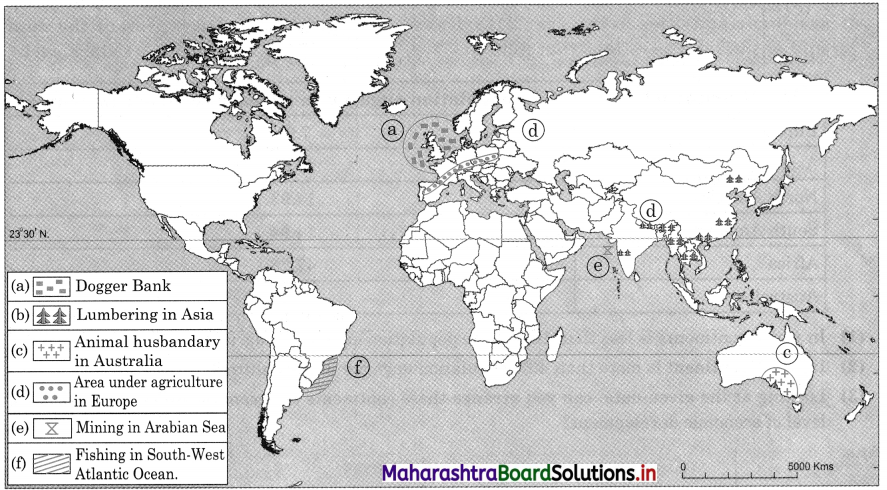
8. Given below is the data about the continent wise employment engaged in primary economic activities in the year 2018. Draw a suitable diagram to represent the data and answer the questions that follow
Question 1.
| Continent | % of population engaged in primary economic activities |
| Europe | 7.91 |
| Asia | 24.49 |
| North America | 14.93 |
| South America | 14.94 |
| Africa | 47.28 |
| Australia | 27.79 |
(1) In which continents is less than 10% of the population engaged in agriculture?
(2) In which continent is more than 40% population engaged in agriculture?
(3) Looking at the given data, can you arrange these continents in ascending order on the basis of level of economic development?
Answer:
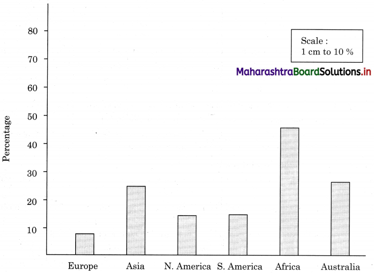
(1) In Europe less than 10% population is engaged in agriculture.
(2) In Africa more than 40% population is engaged in agriculture.
(3) Ascending order is as follows:
Africa, Asia, Australia, South America, North America, Europe
![]()
Class 12 Geography Chapter 4 Primary Economic Activities Intext Questions and Answers
Try this.
Question 1.
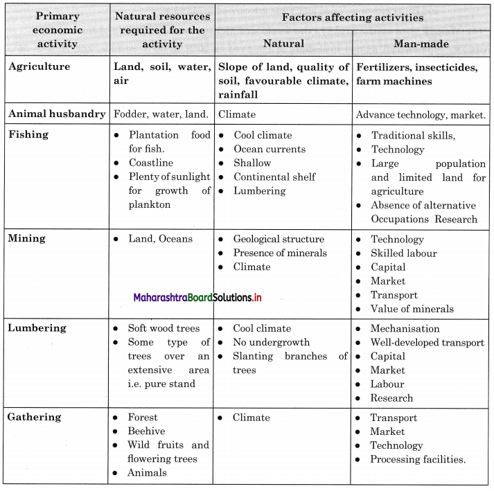
Complete the table. (Textbook Page No. 33)
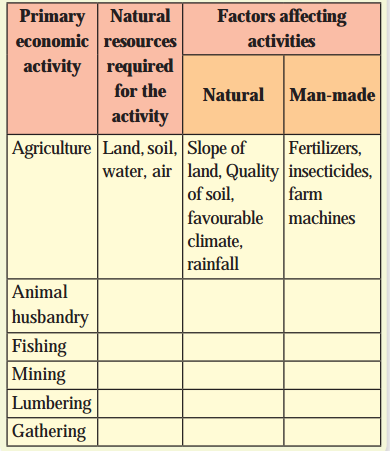
Answer:
Question 2.
Complete the chain by observing columns A to C. Write the number of the relevant characteristics and type of agriculture in column A. (Textbook Page Nos. 37-39)
Answer:
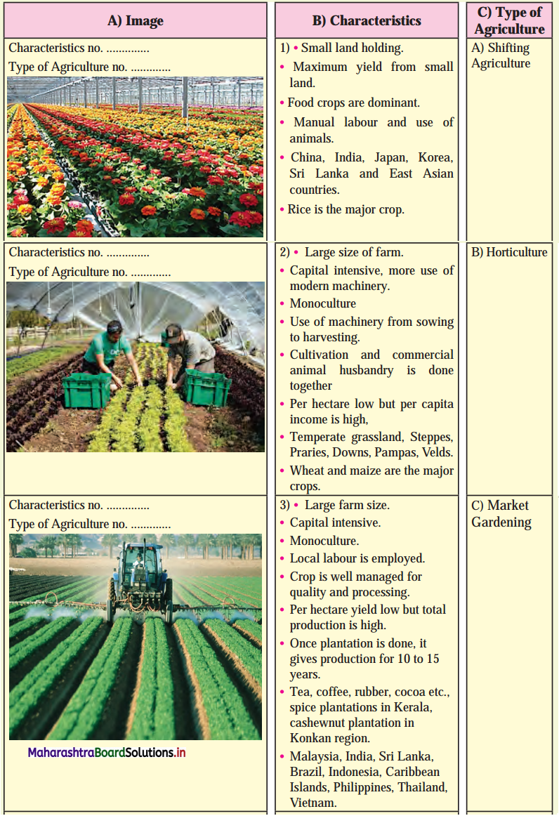
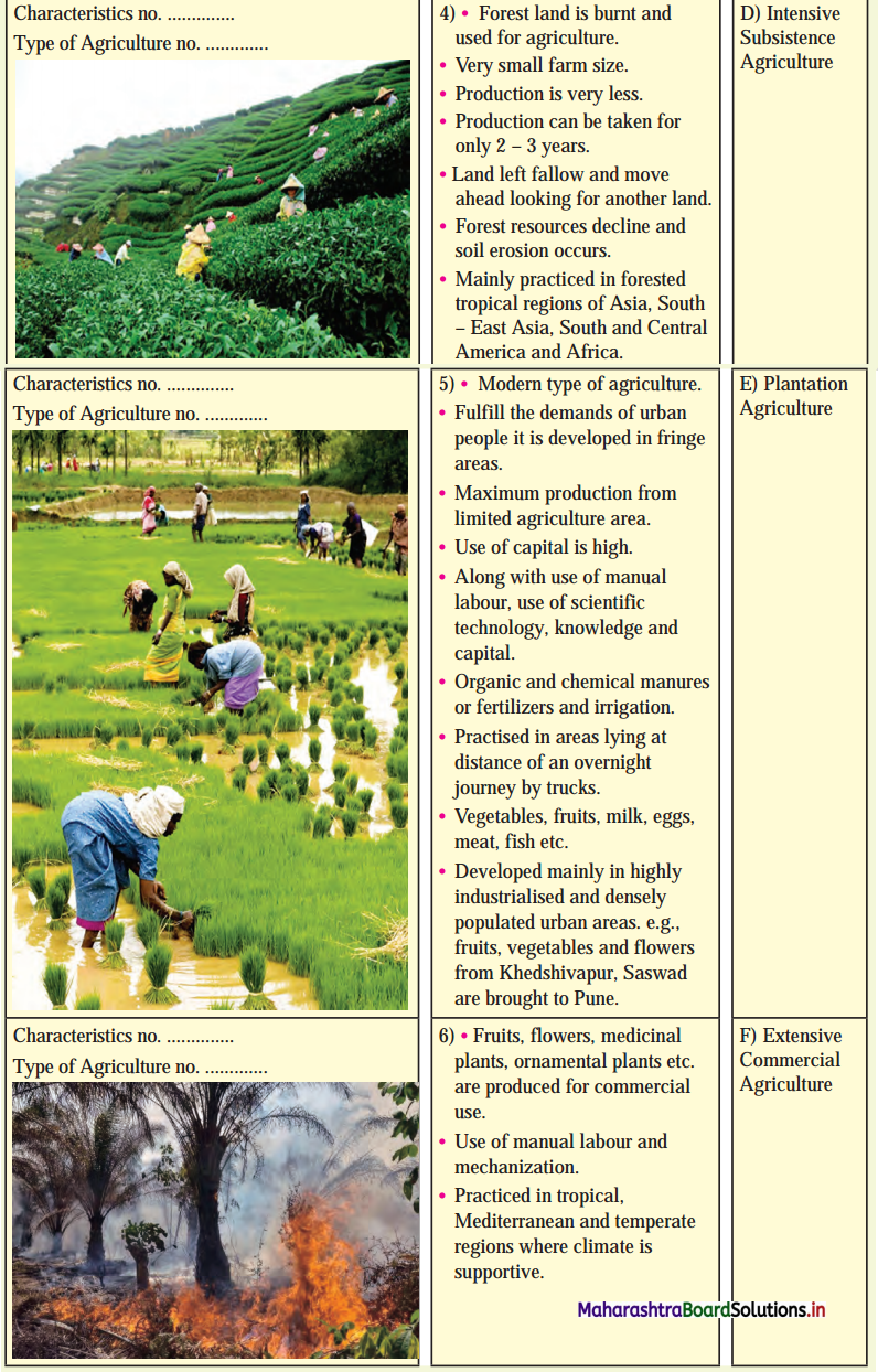
Question 3.
On the basis of the information given and pictures shown in textbook fig. classify the factors affecting agriculture into physical and human factors. (Textbook Page No. 39)
Answer:
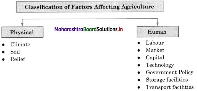
Give it a try.
Question 1.
Complete table. (Textbook Page No. 34)
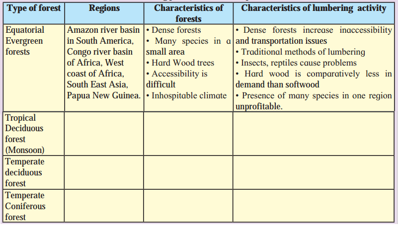
Answer:
Lumbering practiced in different parts of the world.
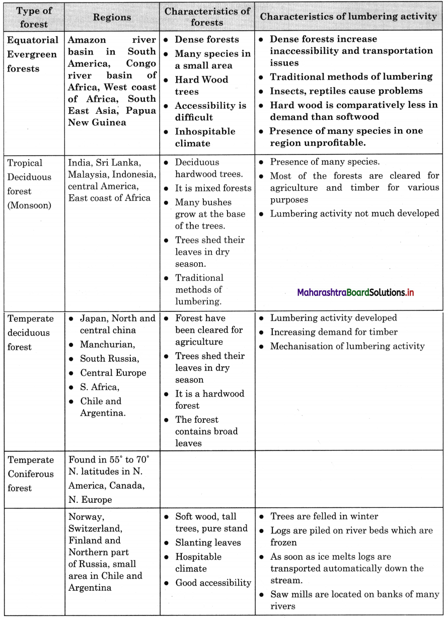
![]()
Make friends with maps!
Question 1.
Observe the map (Textbook Page No. 32) and answer the following questions (Textbook Page No. 33)
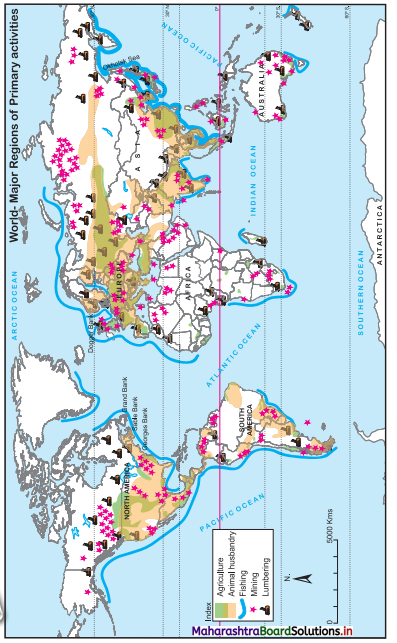
(i) Which economic activities are shown in the following map?
(ii) In which region do you don’t find any activity? what could be the reason?
(iii) In which latitudes do you primarily find the distribution of lumbering activity?
(iv) Why is fishing occupation only found in certain areas in the oceans?
(v) Which primary economic activities are mostly found in Europe?
(vi) What production does the symbol of mining shown in seas and oceans depict?
(vii) In which continent mining is not found?
(viii) In which ocean is the world’s fishing mostly carried out?
(ix) Which primary economic activities are found to the south of Tropic of Capricorn?
(x) Which primary activity is found in the islands of South East Asia?
(xi) Considering all four continents, in which continent do you find less agriculture being practiced?
(xii) Write a paragraph on relationship between latitudinal extent of agriculture and climate in your own words.
Answer:
(i) Agriculture, animal husbandry, fishing, mining and lumbering are the economic activities shown in the map.
(ii) In Antarctica region we do not find any activity because of permafrost and uninhabited continent.
(iii) Lumbering activity is primarily found in 50° to 70° North latitudinal region.
(iv) Fishing can develop only in those areas in the oceans where continental shelf is broad and shallow, meeting of cold and warm ocean water currents and availability plankton food for fish, cool climate etc. Since these physical factors are found only certain areas, so fishing occupation is developed in certain areas only. For example, Dogger banks in Europe or Grand Banks in north eastern part of USA etc.
(v) Agriculture, lumbering, mining and animal husbandry are the primary economic activities found in Europe.
(vi) A star (★) symbol for mining is shown for the production of mining in seas and oceans.
(vii) Mining is not found in the continent of Antarctica.
(viii)The world’s fishing is mostly carried out in the Atlantic Ocean.
(ix) Agriculture, mining, fishing, lumbering and animal husbandry are the primary economic activities found to the south of Tropic of Capricorn.
(x) Agriculture, fishing, and lumbering are the economic activities found in the islands of South East Asia.
(xi) Out of the four continents less agriculture is practiced in the continent of Australia.
(xii) Considering latitudinal extent except North Africa agricultural activities are important economic activities in latitudinal belt 8° to 50° North parallel of latitudes in the northern hemisphere and 20° to 45° latitudes in the southern hemisphere.
- Climate is the most important deciding factors in the development of agriculture.
- With the exception of a few areas, no country in this latitudinal belt experiences snowfall or frost. These weather phenomenon are harmful for the development of agriculture.
- Rainfall in this latitudinal belt is also sufficient and fairly distributed except deserts in continents of Asia and Africa.
- These are all generalised statements. However, agriculture in these latitudinal belts is affected as per the local variations in local weather conditions and physiography of the region.
Can you tell?
Question 1.

(i) Identify the images given in fig. (Textbook Page No. 34)
(ii) What are these products made from?
(iii) What do you find the raw material that are required to make these products.
(iv) What is the occupation of obtaining these products called?
Answer:
(i) Honey, brush, chewing gum, tendu leaves, rope, broom, ornament and wild fruits images are given in photograph.
(ii) These products are made from nature.
(iii) The raw material required is coconut coir, rubber, tendu trees, honeybee and wood.
(iv) The occupation is called food gathering.
Question 2.
List out the effects of deforestation on the environment, animals, birds and humans. (Textbook Page No. 35)
Answer:
- For thousands of years man has been using forests for his shelter, food and clothing and therefore, world’s forest resources are gradually diminishing.
- If, too many trees are cut, forest is not capable of re-establishing itself. This may lead to many environmental problems.
Some of the important problems are as follows.
- After deforesting in many areas, a decrease in rainfall could be noticed.
- As a result of rapid deforestation environmental problems like floods, cyclones, soil erosion, tsunami etc., are increasing.
- Due to large scale deforestation in India, 79 species of mammals, 44 species of birds, 15 species of reptiles and 3 species of amphibians are threatened.
- Nearly 1,500 plant species are considered endangered.
![]()
Find out.
Question 1.
With the help of internet, find out about Wild Life (Conservation) Act. (Textbook Page No. 33)
Answer:
Wildlife Protection Act, 1972 and Amendment in 1991.
(i) Objective of the Act is to protect the wild animals, birds and plants particularly the endangered or threatened species.
(ii) The Act prohibits the capturing, killing, poisoning or trapping of wild animals.
(iii) A national wildlife action plan has been made under it.
(iv) The Act envisages the creation and management of sanctuaries and national parks.
(v) A section has also been incorporated for creation of Biosphere Reserves.
The objectives and components of the Act are as follows:
- Control the rapid decline of wildlife. Therefore, specified endangered species are to be protected as a matter of priority.
- In general, protect all species.
- Prohibit regulate hunting (prohibit unlicensed poaching) of wild animals and birds.
- Prohibit regular trade in wild animals, their body parts and articles made by using their body parts.
- Set up protected areas like wildlife sanctuaries and national parks.
- Set up central 200 authorities to regulate zoos and encourage captive breeding of endangered species in the zoos.
- Constitute a wildlife Advisory Board in each state to advice the respective state Governments.
In 1991, the Act was amended to include plants in its definition of wildlife. Until then, for almost two decades, protection of plant life was not on agenda.
Question 2.
Find out how over exploitation of all kinds of animal resources affect human lives and environment. (Textbook Page No. 36)
Answer:
- Due to over exploitation of animal resources there is over grazing and heavy soil erosion.
- Many times, heavy soil erosion results into desertification of land.
- Many times, trees, shrubs and even their roots are used by rural people to feed the animals, it results into deforestation and desertification becomes intense.
- All disadvantages of soil erosion and desertification are faced by human beings.
Question 3.
Mining causes air, water, land and noise pollution on large scale. Look for one example each. (Textbook Page No. 37)
Answer:
- Environment impact of mining can occur at local, regional and global scales through direct and indirect mining practices.
- Impact can result in erosion, sinkholes, loss of biodiversity or the contamination soil. Example of land erosion due to mining is Tedi mines in Papua New Guinea.
- There is pollution of ground water and surface water by the chemicals emitted from mines.
- These processes also have impact on the atmosphere from the emissions of carbon, which have effect on the quality of human health and also biodiversity.
Think about it.
Question 1.
What is the difference between fishing and pisciculture? (Textbook Page No. 36)
Answer:
- The term ‘fishing’ includes all human efforts to obtain the aquatic animals in the sea, inland water and rivers.
- Breeding, rearing and transplantation of fish by artificial means is called pisciculture.
- In other words, pisciculture is fish farming. It involves raising of fish commercially in tanks or enclosures.
![]()
Question 1.
Observe the given map in fig. (Textbook Page No. 32) and answer the following questions. (Textbook Page No. 34)
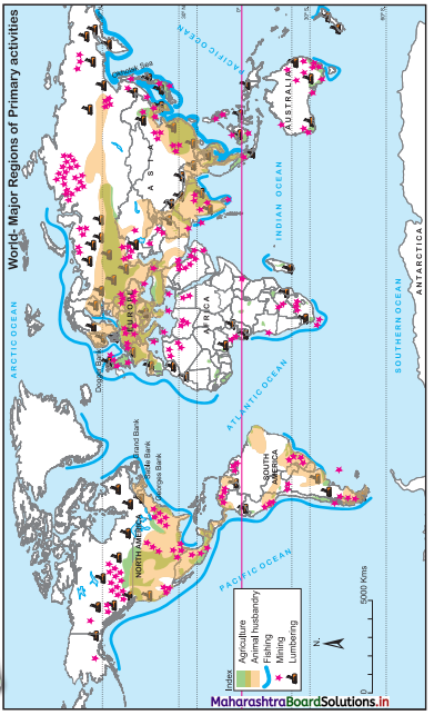
(i) Which countries in the monsoon region practice lumbering on large scale.
(ii) In which part of Australia is lumbering carried on?
(iii) Why do you think lumbering is not carried out in the Northern part of Africa?
(iv) Write a note on relationship between latitudes and lumbering.
(v) Why lumbering is not developed on commercial level in Equatorial region?
Answer:
(i) India, Myanmar, Nepal, Cambodia, Vietnam and Philippines.
(ii) In south western and south eastern part of Australia lumbering is carried on.
(iii) Lumbering is not carried in Northern part of Africa because it is covered by Sahara Desert.
(iv) Lumbering is practiced in the areas where forest grows.
- Different types of forest need different rainfall and temperature conditions for growth of trees.
- The temperature and rainfall are related to latitude.
- Monsoon forests grow in areas of moderate temperature and rainfall; thus, they grow in 30°N to 40°N latitude.
- Coniferous forests grow in cool climate so they grow in 50°N to 70°N latitude
(v) Commercial lumbering is not developed in Equatorial region due to following reasons.
- In Equatorial region there dense and mixed forest growth. Land is covered with marshes.
- The trees provide hardwood which is hard to cut and heavy to carry.
- Due to hardwood it has less demand in the world market.
- Hot and humid climate of this region is not suitable for labour.
- Transport facilities are not well developed.
- Traditional methods of lumbering are used.
Question 2.
Observe the map in figure. (Textbook Page No. 32) and answer the questions given below. (Textbook Page No. 35)
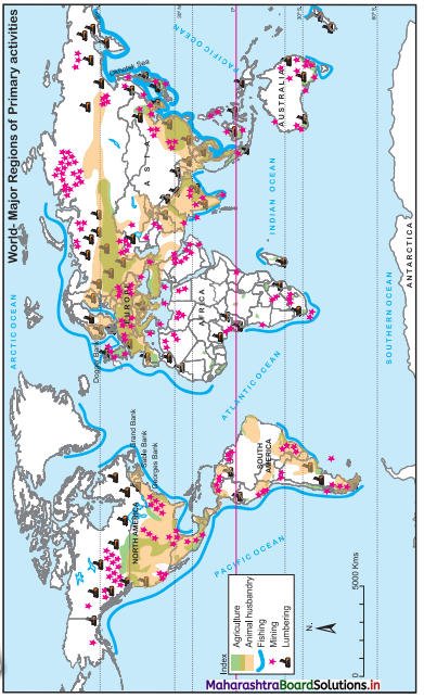
(i) Along which bank of North America is Grand bank located?
(ii) Along which coast of South America is the fishing mostly practiced?
(iii) In which part of Australian continent fishing activity developed?
(iv) Fishing is carried on large scale on the western coast of Africa than on the eastern coast of Africa. Give reasons.
(v) Commercial fishing is practiced on the southern coastline of Greenland. Give reasons.
Answer:
(i) Along North-Eastern bank of North America Grand bank is located.
(ii) Along the Western coast of South America fishing is mostly practiced.
(iii) Along South Eastern part of Australian continent fishing activity is developed.
(iv) Along the western coast of Africa, the continental shelf is broad and water is shallow.
- The Guinea and Benguela warm current and Canary cold current meet together near the Western coastline of Africa, so lot of plankton is available.
- The Western coastline is broken so it is suitable for fishing.
- There is more demand for fish along the western coastline because supply of agricultural goods and meat is limited.
- On the eastern coast of Africa, the continental shelf is narrow, water near the coastline is shallow coastline is smooth, limited plankton etc so fishing is not carried on large scale.
- Therefore, fishing is not carried on large scale on the eastern coast of Africa.
(v) The southern coastline is the traditional area of fishing in Greenland.
- The continental shelf of southern coastline is broad and water near the coastline is shallow.
- The southern coastline of Greenland is broken so it is suitable for fishing.
- The West Greenland current flows along the south coastline of Greenland which brings plenty for plankton near southern coastline.
- It is traditional occupation so skilled people are available for fishing.
- The cold climate of Greenland is suitable for fishing.
- The important species of fish caught near southern coastline of Greenland are Greenland Halibut, Atlantic cod, Snow crab, Atlantic Herring etc.
Question 3.
Look at the map in fig. (Textbook Page No. 32) and answer the following questions. (Textbook Page No. 36)
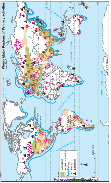
(i) Do you think there is correlation between animal husbandry and grassland?
(ii) In which continent animal husbandry not practiced on large scale?
(iii) In which regions of the world do animal husbandry and agriculture coincide?
(iv) Animal husbandry is found in between which latitude of the world?
(v) In which zone between 30°North to 30°South latitudes, is animal husbandry not found on large scale? What could be the reason behind.
(vi) What could be the reason of concentration of animal husbandry in the eastern part of Australia?
(vii) Why is animal husbandry developed more in the arid regions of the interior of the continents?
Answer:
(i) Yes, there is correlation between animal husbandry and grassland because animals are grazed on grassland.
(ii) In Africa continent animal husbandry not practiced on large scale.
(iii) In North America, Europe and Asia animal husbandry and agriculture coincide.
(iv) Animal husbandry is found between 30° North to 60° North and 30° South to 55° South.
(v) In a zone between 5° North to 5° South latitudes, animal husbandry is not found on large scale. This zone has equatorial climate, so dense forest growth and inhospitable climate and lack of good quality grass are the reasons for no development of animal husbandry in above mentioned zone.
(vi) For the development of animal husbandry, climate is more important factor. In eastern part of Australia, the climate is suitable for the growth of good quality grass, therefore, animal husbandry is more developed.
(vii) The arid regions of interior of the continents receive very low rainfall.
- Only grass grows in low rainfall areas.
- Due to limited water supply, other economic activities cannot be developed.
- Therefore, only animal husbandry can be developed with the help of grass.
Question 4.
Look at the Fig. (Textbook Page No. 32) and answer the following questions (Textbook Page No. 36 and 37)
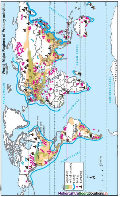
(i) In which part of North American continent is mining mainly found?
(ii) Mining activity is located along which coastal side of South America?
(iii) Comparing other primary economic activities, do you think the extent of mining is related to latitude.
(iv) Looking at the concentration of mining in the world, can you relate it with the economic development of the country?
Answer:
(i) Along North Eastern and Western coastline of USA and South Western part of Canada.
(ii) Northern, Western and Southern coastline of South America.
(iii) No, the extent of mining is not related to latitude.
(iv) Yes, we can relate mining with economic development of the country because minerals provide raw material to many industries, especially heavy industries. Therefore, countries rich in minerals have more economic development. For example, USA, Developed countries of Europe.
Class 12 Geography Solutions Digest
- Population Part 1 Geography Class 12 Question Answer
- Population Part 2 Geography Class 12 Question Answer
- Human Settlements and Land Use Geography Class 12 Question Answer
- Primary Economic Activities Geography Class 12 Question Answer
- Secondary Economic Activities Geography Class 12 Question Answer
- Tertiary Economic Activities Geography Class 12 Question Answer
- Region and Regional Development Geography Class 12 Question Answer
- Geography: Nature and Scope Geography Class 12 Question Answer