Balbharti Maharashtra State Board Class 11 Geography Important Questions Chapter 3 Agents of Erosion Important Questions and Answers.
Maharashtra State Board 11th Geography Important Questions Chapter 3 Agents of Erosion
Complete the chain.
Question 1.
| Agent | Processes | Erosional / Deposition features |
| (1) River | (1) Plucking | (1) Hollows |
| (2) Wind | (2) Solution | (2) Potholes |
| (3) Glacier | (3) Deflation | (3) Sinkholes |
| (4) Groundwater | (4) Drilling | (4) Roche moutonnees |
Answer:
| Agent | Processes | Erosional / Deposition features |
| (1) River | (1) Drilling | (1) Potholes |
| (2) Wind | (2) Deflation | (2) Hollows |
| (3) Glacier | (3) Plucking | (3) Roche moutonnees |
| (4) Ground water | (4) Solution | (4) Sink holes |
![]()
Question 2.
| Agent | Erosional features | Depositional features |
| (1) River | (1) Gorge | (1) Moraine |
| (2) Sea waves | (2) Cirque | (2) Barchan |
| (3) Wind | (3) Sea cliff | (3) Sand bars |
| (4) Glaciers | (4) Mushroom rock | (4) Food plains |
Answer:
| Agent | Erosional features | Depositional features |
| (1) River | (1) Gorge | (1) Food plains |
| (2) Sea waves | (2) Sea cliff | (2) Sand bars |
| (3) Wind | (3) Mushroom rock | (3) Barchan |
| (4) Glaciers | (4) Cirque | (4) Moraine |
Question 3.
| Agent | Erosional features | Deposition features |
| (1) Ground water | (1) Wave cut platforms | (1) Loess |
| (2) Wind | (2) Horn | (2) Beach |
| (3) Glacier | (3) Sink holes | (3) Stalactites |
| (4) Sea waves | (4) Yardang | (4) Eskers |
Answer:
| Agent | Erosional features | Deposition features |
| (1) Ground water | (1) Sink holes | (1) Stalactites |
| (2) Wind | (2) Yardang | (2) Loess |
| (3) Glacier | (3) Horn | (3) Eskers |
| (4) Sea waves | (4) Wave cut platforms | (4) Beach |
Choose the correct option by identifying the correct correlation in the sentences.
Question 1.
In mountainous areas river flows at a higher speed. Here, …………………
(a) bed gets more eroded than banks
(b) banks get more eroded than bed
(c) both bed and bank get eroded
(d) none of the above
Answer:
(a) bed gets more eroded than banks
Question 2.
The particles of sand are blown away by the wind. After removal the portion from where sand blown off appears as depression. These are called ……………….
(a) Potholes
(b) Barchans
(c) Sand dunes
(d) Deflation hallows
Answer:
(d) Deflation hallows
Question 3.
Landforms developed by underground water anywhere in the world are called ……………….
(a) Deltas
(b) Karst
(c) Aeolian
(d) None of the above
Answer:
(b) Karst
Question 4.
Where two tributary glaciers join together, their lateral moraines merge underneath …………………
(a) to form terminal moraines
(b) to form medial moraines
(c) to form lateral moraines
(d) to form ground moraines
Answer:
(b) to form medial moraines
![]()
Question 5.
In this process of transportation, the material acquired by the agents is transported by rolling, pushing and dragging along the surface. The material consists of boulders and big rocks.
(a) Abrasion
(b) Attrition
(c) Traction
(d) Saltation
Answer:
(c) Traction
Question 6.
The process by which moving ice exerts pressure on majority portion of rocks on bed or along the bank is known as ………………..
(a) Abrasion
(b) Plucking
(c) Attrition
(d) Solution
Answer:
(b) Plucking
Question 7.
When rocks and pebbles bump into each other and break up into smaller fragments it is called ………………
(a) Attrition
(b) Abrasion
(c) Drilling
(d) Deflation
Answer:
(a) Attrition
Question 8.
Drumlins are formed by deposition by …………………..
(a) Rivers
(b) Sea waves
(c) Glaciers
(d) Wind
Answer:
(c) Glaciers
Question 9.
Sometimes, waves can erode the softer part and make it hollow enough to be called a ………………..
(a) Cave
(b) Beach
(c) Headland
(d) Sea cliff
Answer:
(a) Cave
Question 10.
………………….. beach at Chennai is the longest beach in India.
(a) Diveagar
(b) Guhagar
(c) Harihareshwar
(d) Marina
Answer:
(d) Marina
Question 11.
The ………………… Lake in Orissa becomes a fresh water lagoon during monsoons.
(a) Dal
(b) Wular
(c) Chilika
(d) Periyar
Answer:
(c) Chilika
Identify the correct correlation.
A : Assertion
R : Reasoning
Question 1.
A – In river beds, gravels and pebbles are often rounded.
R – The rock materials carried in the flow tumble and bounce against one another.
(a) Only A is correct.
(b) Only R is correct.
(c) Both A and R are correct and R is the correct explanation of A.
(d) Both A and R are correct but R is not the correct explanation of A.
Answer:
(c) Both A and R are correct and R is the correct explanation of A.
![]()
Question 2.
A – The alluvial fans are formed at the foothills.
R – When the river enters the plains, there is change in slope and the velocity of the river increases abruptly.
(a) Only A is correct.
(b) Only R is correct.
(c) Both A and R are correct and R is the correct explanation of A.
(d) Both A and R are correct but R is not the correct explanation of A.
Answer:
(a) Only A is correct.
Question 3.
A – Some rivers may not form deltas.
R – They do not have huge load of sediment.
(a) Only A is correct.
(b) Only R is correct.
(c) Both A and R are correct and R is the correct explanation of A.
(d) Both A and R are correct but R is not the correct explanation of A.
Answer:
(c) Both A and R are correct and R is the correct explanation of A.
Question 4.
A – Large waves do not get generated in lagoons as they get separated from the sea.
R – The lagoons becomes fresh water lagoon during monsoon.
(a) Only A is correct.
(b) Only R is correct.
(c) Both A and R are correct and R is the correct explanation of A.
(d) Both A and R are correct but R is not the correct explanation of A.
Answer:
(d) Both A and R are correct but R is not the correct explanation of A.
Question 5.
A – In arid areas, the eroded portion of softer rocks appear like elongated ridges and harder rocks appear as elevated portions.
R – Softer rocks get more eroded faster.
(a) Only A is correct.
(b) Only R is correct.
(c) Both A and R are correct and R is the correct explanation of A.
(d) Both A and R are correct but R is not the correct explanation of A.
Answer:
(c) Both A and R are correct and R is the correct explanation of A.
Identify the incorrect factor.
Question 1.
In the following agent’s abrasion process is used in erosion.
(a) Wind
(b) Sea waves
(c) Glacier
(d) Ground water
Answer:
(d) Ground water
Question 2.
In the following agent’s attrition process is used in erosion,
(a) Ground water
(b) Wind
(c) River
(d) Sea waves
Answer:
(a) Ground water
![]()
Question 3.
Solution process of erosion is used in the following agents.
(a) Ground water
(b) Glacier
(c) River
(d) Sea waves
Answer:
(b) Glacier
Question 4.
Lateral erosion process is found in the following agents.
(a) River
(b) Sea waves
(c) Wind
(d) Glacier
Answer:
(c) Wind
Question 5.
Suspension is the process of transportation used by following agents.
(a) Ground water
(b) River
(c) Wind
(d) Sea waves
Answer:
(a) Ground water
Question 6.
Saltation process of transportation is used by following agents.
(a) River
(b) Sea waves
(c) Glacier
(d) Wind
Answer:
(c) Glacier
Question 7.
The erosional landforms of glaciers are.
(a) Cirque
(b) Horn
(c) Moraine
(d) Arete
Answer:
(c) Moraine
Question 8.
The depositional landforms of glaciers are.
(a) Eskers
(b) Drumlin
(c) Erratic rock
(d) Barchan
Answer:
(d) Barchan
Question 9.
The depositional features of ground water are.
(a) Stalactite
(b) Sea stack
(c) Pillar
(d) Stalagmite
Answer:
(b) Sea stack
Question 10.
The erosional features of wind are.
(a) Loess
(b) Ventifacts
(c) Deflation hollows
(d) Yardang
Answer:
(a) Loess
![]()
Question 11.
The depositional features of wind are.
(a) Longitudinal dunes
(b) Loess
(c) Barchan
(d) Flood plains
Answer:
(d) Flood plains
Question 12.
The erosional features of sea waves are.
(a) Sea arch
(b) Sea caves
(c) Sink holes
(d) Wave cut platforms
Answer:
(c) Sink holes
Question 13.
The depositional features of sea waves are.
(a) Beaches
(b) Sand bars
(c) Lagoon
(d) Delta
Answer:
(d) Delta
Question 14.
The erosional features of rivers are.
(a) U-Shaped valley
(b) Gorge
(c) Waterfall
(d) Potholes
Answer:
(a) U-Shaped valley
Question 15.
The depositional features of rivers are.
(a) Oxbow lake
(b) Flood plains
(c) Moraines
(d) Meanders
Answer:
(c) Moraines
Complete the table.
Question 1.
| Agent | Erosional landforms | Deposition landforms |
| (1) River | — | — |
| (2) Wind | — | — |
| (3) Sea Waves | — | — |
| (4) Groundwater | — | — |
| (5) Glacier | — | — |
Answer:
| Agent | Erosional landforms | Deposition landforms |
| (1) River | Gorges, V-shaped valleys, canyons, waterfalls, potholes | Alluvial fans, meanders, flood plains, natural levees, deltas |
| (2) Wind | deflation hollows, ventifacts mushroom rock, yardang | Sand dunes, loess, barchans |
| (3) Sea Waves | Sea cliffs, cave, sea stack, sea arches, wave cut platform | Beach, sand bar, lagoon, sand pits |
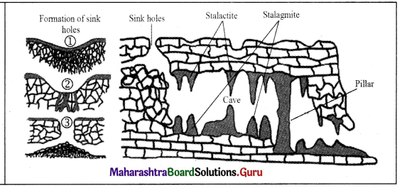
| (4) Groundwater | Sink holes, caves | Stalactite, stalagmites, pillars |
| (5) Glacier | Roche mountonnees, cirque, arete, horn, U-shaped valley, hanging valley | Drumlins, eskers, erratic rock, lateral moraines, end moraines, terminal moraines, medial moraines |
Question 2.
| Agent | Process of erosion | Process of deposition |
| (1) River | — | — |
| (2) Wind | — | — |
| (3) Sea Waves | — | — |
| (4) Groundwater | — | — |
| (5) Glacier | — | — |
Answer:
| Agent | Process of erosion | Process of deposition |
| (1) River | attrition, solution, drilling, downcutting, headward erosion, lateral erosion | traction, saltation, suspension |
| (2) Wind | abrasion, attrition, deflation | traction, saltation, suspension |
| (3) Sea Waves | abrasion, attrition, solution, lateral erosion | traction, saltation, suspension |
| (4) Groundwater | solution | solution |
| (5) Glacier | plucking, abrasion, downcutting, headward erosion, lateral erosion | traction |
Give geographical reasons.
Question 1.
The coastal zone management warrants serious attention.
Answer:
The coastal zone management warrants serious attention because-
- Compared to the other agents of erosion the work of sea waves goes on ceaselessly.
- Erosion in some part and deposition in the adjoining part keeps on taking place constantly. The beaches and bars which are formed due to deposition are also eroded.
- Coastal regions are always vulnerable to the risk of getting submerged due to increase in sea level.
- Coastal regions are also the regions of high population density.
![]()
Question 2.
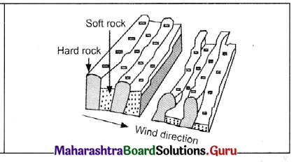
Mushroom rocks have broad tops.
Answer:
Mushroom rocks have broad tops because-
- The high rising rocks in the path of the wind are attacked by the sand that moves with the wind.
- Winds and the particles they carry, attack the base of an individual rock.
- The larger top part is not eroded as much as the basal part since, the particles carried by the wind being heavy are not uplifted up to the top portion of the rock.
- The particles at medium height are smaller but their velocities are high. Hence, their impact is more.
- As a result, the portion of rock at medium height is eroded more and the rock as a whole gets the shape of a mushroom.
Question 3.
All rivers do not form delta.
Answer:
All rivers do not form delta because –
- Delta is a place near the seashore where the sediments brough down by a river are deposited in triangular form.
- Most of the rivers finally join to the sea but every river does not form delta because they do not have the huge load of sediments.
- If the rivers are travelling from a long distance, they join many tributaries and they deposit the sediment into the main river. Such long and sluggish rivers can deposit sediment at the river mouth and form delta. For example, The River Ganga has formed a huge delta.
- Some rivers are short and swift. They do not receive more tributaries, so such rivers have less sediments. These rivers flow very swiftly so they deposit sediments in the sea water. Therefore, they do not form delta.
Differentiate between.
Question 1.
Headward erosion and Lateral erosion.
Answer:
| Headward erosion | Lateral erosion |
| (i) Headward erosion is the backward erosion by river in the source region. | (i) Lateral erosion is the erosion that occurs on the sides of valleys of a river or glacier. |
| (ii) This is carried away by the river. | (ii) The valley slopes are eroded by tributary streams. |
| (iii) Headward erosion causes the river to move backward, because erosion takes place in the opposite direction of the follow of river. | (iii) Lateral erosion causes widening of valley, because lateral erosion occurs in the valley sides. |
Question 2.
Plucking and Abrasion.
Answer:
| Plucking | Abrasion |
| (i) Plucking is the process by which moving ice exerts pressure on rocks on bed or along the bank. | (i) Abrasion involves the scratching and polishing of the surface or bedrock by the particles moving on it. |
| (ii) The pressure on the rock causes uprooting of rock portion that is exposed to the flow. | (ii) The rock particles involved in abrasion rub against rock and wear away the surface. |
| (iii) The eroded bedrock will have rugged surface. | (iii) The eroded bedrock will have smooth surface. |
Question 3.
Barchan and Longitudinal dunes.
Answer:
| Barchan | Longitudinal dunes |
| (i) When there is an obstacle in the path of wind, or due to low velocity of wind, the sand gets dropped at some places. Thus, barchans are formed. | (i) When sand is deposited parallel to the direction of wind, longitudinal dunes are formed. |
| (ii) Barchans are crescent-shaped dunes. The slope that faces the wind is gentle whereas the opposite slope is steep. | (ii) They appear parallel to the wind direction. Sometimes they are 100km long. |
| (iii) Barchans migrate from one place to another. | (iii) Longitudinal dunes do not migrate but extend in the wind direction. |
| (iv) They are seen in the Great Indian Desert of Rajasthan. | (iv) They are seen in Rub-al-Khali desert of Saudi Arabia. |
Write short notes on.
Question 1.
Plucking
Answer:
- It is the process by which moving ice exerts pressure on majority portion of rocks on bed or along the bank.
- The pressure on the rock causes uprooting of rock portion that is exposed to the flow. This uprooting of particles is called plucking.
- The eroded bedrock will have a rugged surface.
- Plucking at the base of a glacier lead to formation of Roche moutonnees.
Question 2.
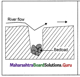
Drilling
Answer:
- Bedload moves along the running water.
- As and when this flow encounters an obstacle due to relief on the bed or joints in the bed, the flow tends to develop a circular pattern.
- This circular system becomes stable, though the water continues to flow in downstream direction.
- This leads to development of a whirl.
- The trapped sediments also follow the similar circular motion.
- The continuous action of these trapped sediments and the whirl deepens the bed of the river at a given point.
- Eventually, it develops into a larger depression assuming a shape of a pot.
- Potholes are the features formed by this process. For example, they are found in River Indrayani at Bhegadewadi in Pune district.
![]()
Question 3.
The Process of deposition
Answer:
- The velocity at which the agent is moving has a great impact on deposition.
- If the stream or wind slows down, the carrying capacity and the particle sizes carried and deposited will decrease.
- If a stream flows faster, say during floods or when the river is in the mountains, then the carrying power of the stream and the sizes of particles deposited will increase.
- If there is a change in the slope of land or in the direction of flow, deposition may occur there.
- The slopes are absent in the plain region. Therefore, the rivers are unable to carry the sediments further and they start depositing.
- Due to gravity, small particles settle more slowly than the larger particles. Smaller particles are carried away by the river or wind till the end and their deposition occurs in the later stage.
- If an obstacle comes in between the flow of the agent it causes the particles to settle and thus deposition takes place.
Question 4.
Moraine
Answer:
- Moraine is a depositional feature of a glacier.
- Glaciers generally deposit load of sediments along the side and front of the ice. These deposits are called moraines.
- There are four types of moraines depending upon the location where sediments are deposited. They are lateral moraines, medial moraines, terminal moraines and end moraines.
- The moraines deposited at the sides of the wall are called lateral moraine.
- When two tributary glaciers join together, their lateral moraines merge underneath to form medial moraines..
- At the foot of the glacier, sediments are deposited like a heap of all grain sizes forming a curved depositional ridge called end moraines. It contains grains of all sizes.
- When sediments are deposited at the snout of glacier, when it melts, it is called terminal moraine.
Draw a neat and labelled diagram for.
Question 1.
Yardangs
Answer:
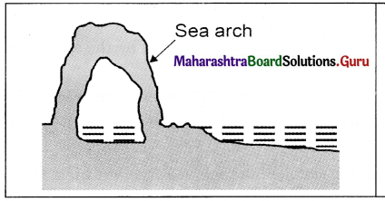
Question 2.
Sea arch
Answer:
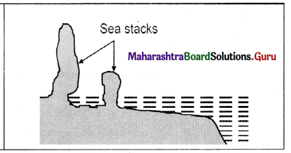
Question 3.
Sea stack
Answer:
Question 4.
Pothole drilling
Answer:
Question 5.
Groundwater
Answer:
![]()
Answer in detail.
Question 1.
Write in detail about the depositional features formed by glaciers.
Answer:
Following are the depositional features formed by glaciers.
Drumlin:
- Coarse Material that moves with glaciers gets deposited at different places in the form of heaps.
- They appear to have egg like shape. Such heaps are called drumlins.
- At times, large number of drumlins get deposited in an area. From a higher elevation, it- appears like a basket of eggs. It is also referred to as ‘basket of eggs topography’.
Eskers:
When the coarse material, moving with the glaciers is deposited in linear and zigzag manner, it is called an esker.
Erratic rock:
- In the areas under the influence of glaciers generally at high latitudes, huge rock pieces are found to have been deposited in the area where the local rocks are of different formation.
- Such rock appears as erratic ones to the area in which they are deposited.
- These can be considered as guest rocks.
Moraines:
- Generally, glaciers deposit load of sediments along the side and front of the ice. These deposits are called moraines.
- The moraines deposited at the sides of the wall are called lateral moraines.
- At the toe or foot of the glacier, sediment is deposited in a jumbled heap of all grain sizes forming a curved depositional ridge called end moraines.
- End moraines, that mark the farthest advance of a glacier called terminal moraines.
- When two tributary glaciers join together, their lateral moraines merge underneath to form medial moraines.
Question 2.
Explain the types of sand dunes.
Answer:
Barchans:
- These are crescent-shaped dunes.
- They form where supply of sand is minimum.
- Due to an obstacle in the path of the wind or due to the lowering of its velocity, the sand moving with it gets dropped at some places.
- The barchan slope that faces the wind is gentle whereas, the opposite slope is steep.
- Such barchans are seen in large numbers in the Sahara Desert of Africa or in the Great Indian Desert in Rajasthan.
Longitudinal Dunes:
- These are long dunes deposited is the direction of the wind.
- They appear parallel to the wind direction.
- They do not migrate like the barchans.
- They are also called seif dunes.
- They are sometimes hundreds of kilometres long. Such dunes can be seen in Rub-al- Khali desert in Saudi Arabia.
![]()
Question 3.
Write about the erosional features formed by river.
Answer:
A river, which is flowing water, erodes rock materials, transports them to newer places and deposits them. In this process, it creates many erosional and depositional landforms. Let us study in details about erosional landforms:
George:
- In mountainous areas, river flows at a higher speed.
- Here, the bed gets more eroded than its banks. Gorges are formed with steep banks and a narrow bed. For example, gorges of river Ulhas and river Narmada. Deeper gorges are called canyons.
V-shaped Valleys:
- Over a period of time, the bed of the river is less eroded.
- Erosion along the banks and the slope of the valley increases.
- The vertical sides of the valley become wide resembling letter V’. These are V-shaped valleys.
Waterfalls:
When a river runs over alternating layers of hard and soft rock, rapids and waterfalls are formed. Jog falls on the Sharavati river.
Potholes:
- They generally originate below waterfalls on where rocks are structurally weak.
- Swirling whirlpool motions of the river water causes stones at the bottom to grind the bedrock and enlarge the potholes by drilling while finer sediments are carried away in the current.
- Potholes may range from a few centimetres to many meters in diameter and depth. For example, large potholes can be seen in the beds of river Kukadi at Nighoj in Ahmednagar district.