Natural Vegetation and Wildlife Question Answer Class 10 Geography Chapter 5 Maharashtra Board

Balbharti Maharashtra State Board Class 10 Geography Solutions Chapter 5 Natural Vegetation and Wildlife Notes, Textbook Exercise Important Questions and Answers.

Std 10 Geography Chapter 5 Question Answer Natural Vegetation and Wildlife Maharashtra Board

Class 10 Geography Chapter 5 Natural Vegetation and Wildlife Question Answer Maharashtra Board

Geography Class 10 Chapter 5 Question Answer Maharashtra Board

Question 1.
On the basis of the information given in the chapter, figures and maps, complete the table below:

S.No Type of forest Characteristics Regions in India Regions in Brazil
1 Tropical Forests Broad-leaved evergreen trees.
2 Semi arid thorny vegetation 1.
2.
3 Savannah Scanty bushes and shrub like trees and rain resistant grass.
4 Tropical
semi-deciduous
Mixed type vegetation.
5 Grasslands Grassland region like the Pampas of Argentina.

Answer:

S. No. Type of forest Characteristics Regions in India Regions in Brazil
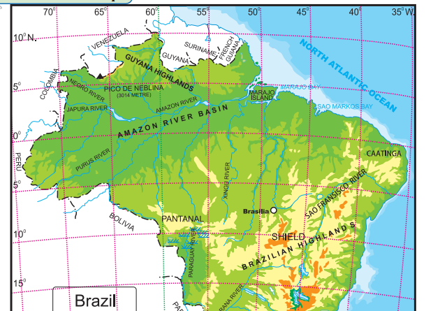
(1) Tropical Forests Broad-leaved evergreen trees. Andaman and Nicobar Islands, the Western Ghats. Some parts of North East India. Amazon Basin, Guyana Highlands.
(2) Semi arid thorny vegetation (a)     Thorny and shrub type vegetation.
(b)   Leaves are small in size. Leaves are modified into thorns to minimise evaporation.
Gujarat, Rajasthan, Parts of Madhya Pradesh and Uttar Pradesh. North-Eastern part of Brazil.
(3) Savannah Scanty bushes and shrub like trees and rain resistant grass. Brazilian Highland.
(4) Tropical

semi-deciduous

Mixed type vegetation. Central India and South India. Parana Basin and South Eastern part of Brazil.
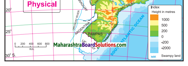
(5) Grasslands Grassland region like the Pampas of Argentina. Foothills of Shiwalik hills and Assam. Southern Brazil.

Maharashtra Board Class 10 Geography Solutions Chapter 5 Natural Vegetation and Wildlife

2. Identify the odd man out:

Question a.
Forest type of Brazil ______.
(a) Thorny bush type vegetation
(b) Evergreen forests
(c) The Himalayan Forests
(d) Deciduous forests
Answer:
(c) The Himalayan Forests

Question b.
With reference to India
(a) Mangrove forests
(b) Mediterranean forests
(c) Thorny bush-type vegetation
(d) Equatorial forests
Answer:
(b) Mediterranean forests

Question c.
With reference to Fauna of Brazil.
(a) Anaconda
(b) Tamairin
(c) Red Panda
(d) Lion
Answer:
(c) Red Panda

Question d.
With reference to flora in India.
(a Deodar
(b) Anjan
(c) Orchid
(d) Banyan
Answer:
(c) Orchid

Maharashtra Board Class 10 Geography Solutions Chapter 5 Natural Vegetation and Wildlife

3. Match the Column:

Column ‘A’ Column ‘B’
Evergreen Forests (a) Sundari trees
Deciduous forests (b) Pine
Coastal forests (c) Pau Brasil
Himalayan forests (d) Khejari
Thorny and bush type vegetation (e) Teak
(f) Orchid

Answer:
1 – c
2 – e
3 – a
4 – b
5 – d

4. Answer in short:

Question a.
Differentiate between the forest types of Brazil and India.
Answer:

Forest type of Brazil Forest type of India
1. The northern part of Brazil lies in the equatorial region. It receives ample sunshine and heavy rainfall. So dense evergreen forests are seen here. 1. The location of India is far away from the Equator. Heavy rainfall occurs only in the Western Ghats and North Eastern hilly areas. So evergreen forests are seen in these regions.
2. The Highland region of Brazil receives low rainfall. So tropical grasslands are seen in this region. 2. The Peninsula region of India receives rainfall between 1000 mm to 2000 mm, so they are covered by deciduous forests.
3. As there are no tall and long extending mountains in Brazil, Himalayan type forests are not found here. 3. Owing to presence of Himalayas, Himalayan type forests are found in North and North-East of India that are classified on the basis of altitude.
4. Thorny shrubs are found to the North Eastern part of Brazilian Highlands which is also considered to be a Drought Quadrilateral. 4. Thorny shrubs are found in India receiving less than 500 mm of rainfall. It is majorly found in Gujarat, Rajasthan and rain shadow regions of the Western Ghats.

Question b.
Correlate wildlife and natural vegetation in India and Brazil.
Answer:
(i) Depending upon favourable geographical conditions, we find a variety of natural vegetation in India and Brazil. Also depending upon the vegetation we find a variety of wildlife in different regions.

(ii) Grasslands of Brazil like the Savannah and the deciduous forest of India have a large number of herbivores and carnivores.

(iii) The dense evergreen forests of India in the west, north east India and the Amazon Basin of Brazil are a home to a large variety of birds, insects, reptiles along with the herbivores and the carnivores.

(iv) Coastal forests and swampy areas of Pantanal and Sunderbans have mangroves, a variety of birds, fishes and reptiles like crocodiles, alligators and the anacondas in Brazil.

(v) Vegetation provides food and shelter to wildlife but if vegetation is limited like in the Thar desert or the Caatinga it will also limit the variety of animals species.

Question c.
What environmental issues are faced by Brazil and India?
Answer:

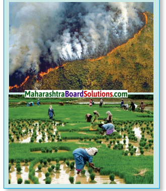
  • Degradation of environment is happening in Brazil due to illegal smuggling of wild animals, slash and burn agriculture (roca), deforestation, pollution, etc.
  • Due to these problems, many endemic species are on the verge of extinction.
  • India too faces environmental issues such as poaching, pollution and the fast spreading deforestation.
  • Many species of wildlife are on the verge of extinction in India.

Question d.
What are the major causes of degradation of forest in Brazil and India?
Answer:
(i) Forests are being cut down as more area is required to expand the cities. Hence rapid urbanisation is one of the reasons for degradation of forest.

(ii) To ensure continuous food supply to meet the needs of the ever increasing population, more and more area needs to be brought under agriculture. For the expansion of agricultural land, forest areas are being cut down.

(iii) In both India and Brazil, forests are being cut down for firewood and for other domestic needs.

(iv) Slash and Burn agriculture which is also known as Roca in Brazil and Jhum in India is responsible for deforestation.

(v) Apart from all the above reasons, forest fire, pollution, overgrazing, etc. are also responsible for the degradation of forests.

Maharashtra Board Class 10 Geography Solutions Chapter 5 Natural Vegetation and Wildlife

Question e.
Why does the deciduous type vegetation occupy most of India?
Answer:

  • Vegetation in a region is affected by the climate and rainfall of the region.
  • In dia lies in the tropical zone and it has a monsoon type climate throughout the year.
  • Also, a major portion of India receives seasonal rainfall between 1000-2000 mm.
  • Deciduous forests thrive well in this condition and these forests shed their leaves during the hot and dry summer so that water is not lost due to evaporation.
  • Teak, bamboo, banyan, peepal, etc. are the trees found in deciduous forest of India.

5. Give geographical reasons:

Question a.
The northern part of Brazil is covered with dense forests.
Answer:

  • The northern part of Brazil lies in the equatorial region.
  • It receives ample sunlight and about 2000 mm of rainfall throughout the year.
  • In this region, the growth of vegetation is very rapid.
  • So, the northern part of Brazil is covered with dense and evergreen forests.

Question b.
Vegetation is scarce in the high altitude of the Himalayas.
Answer:

  • As the altitude increases, the temperature decreases.
  • The climate is very cold in the high altitudes. In Jammu and Kashmir and parts of Himalayas temperature drops to -40fiC.
  • Also this region is snow-covered for most part of the year.
  • Very few species of plants can survive in such extreme conditions. Only seasonally flowering trees are found at higher altitudes.
  • Hence, vegetation is scarce in the high altitude of the Himalayas.

Question c.
A wide variety of insect species is found in Brazil.
Answer:

  • Insects are mostly found in forests, grasslands and swampy lands.
  • Many insects eat leaves, grass and nectar from the plant.
  • The evergreen rainforests are seen in the northern parts of Brazil. The grasslands are found in the central parts and Paraguay-Parana river basin. Similarly, swampy lands are found in Pantanal region in Brazil. .
  • Therefore, a wide variety of insect’s species is found in Brazil.

Question d.
Wild life in India is decreasing day by day.
Answer:
(i) Wildlife in India is decreasing day by day because of rapidly occurring deforestation, poaching, pollution.

(ii) Expansion of cities to accommodate the growing population is leading to cutting down of the valuable forest which leads to the loss of the habitat of wildlife.

(iii) Also the problem of pollution has become severe due to urbanisation. Various types of pollution have threatened the lives of many of the species.

(iv) Poaching of wildlife species have also led to the loss of wildlife in India.

(v) Agricultural practices like shifting cultivation has also reduced the forest cover leading to loss of wildlife habitat.

Question e.
Like India, there is a need for conservation of forests in Brazil too.
Answer:
(i) Like India, Brazil is facing the problem of degradation of environment due to deforestation, pollution, slash and burn agriculture, illegal smuggling of wild animals, etc.

(ii) Trees are being cut down to obtain wood, leading to large scale deforestation in both countries.

(iii) Also the problem of pollution has become severe due to urbanisation. Various types of pollution have threatened the lives of many of the species.

(iv) Agricultural practices like slash and burn agriculture (roca) has reduced the forest cover in Brazil.

(v) Like India, the problem of illegal smuggling of animals has affected Brazil too.

(vi) Hence there is a need for conservation of forests in both Brazil and India.

Class 10 Geography Chapter 5 Natural Vegetation and Wildlife Intext Questions and Answers

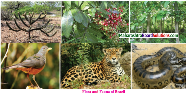
Observe the images given below and discuss on the basis of the following points and answer the following questions:
Maharashtra Board Class 10 Geography Solutions Chapter 5 Natural Vegetation and Wildlife 20
Question 1.
Can you tell the names of the plants/trees shown in the image?
Answer:
Coffee, cactus, rubber.

Question 2.
Where have you seen these plants before?
Answer:
Brazil.

Question 3.
Name the fauna shown in the image.
Answer:
Rufous bellied thrush, leopard, green anaconda.

Question 4.
Where have you seen them before?
Answer:
On the internet and in movies.

Maharashtra Board Class 10 Geography Solutions Chapter 5 Natural Vegetation and Wildlife

Question 5.
In which country do you find a greater diversity of vegetation? What is the reason behind it?
Answer:
Brazil has a greater diversity of vegetation because of the variation in climatic conditions.

Colours Of Both

Question 1.
In which country do equatorial forests occupy a greater area? What could be the reason behind it?
Answer:
Equatorial forests occupy a greater area in Brazil. This is because the Equator passes through northern part of Brazil. Hence, the climate is generally hot throughout the year. Moreover, this region receives heavy rainfall throughout the year.

Question 2.
Which type of forests found in India are not found in Brazil?
Answer:
Himalayan forests are found in India and not in Brazil.

Question 3.
Which type of forests found in Brazil are found in India too?
Answer:
Evergreen forests, deciduous forests, and thorny shrub type vegetation are found in both Brazil and India.

Question 4.
In which country a greater diversity of vegetation is found? What is the reason behind it?
Answer:
Brazil has a greater diversity of vegetation because of the equatorial climate, ample sunlight, heavy rainfall, and vast forest expanse.

Question 5.
Considering the climate and vegetation types, in which country will forest-based occupations flourish?
Answer:
Forest-based occupations will flourish more in Brazil.

Activity

Question 1.
Correlate geographical conditions and the flora and fauna there? (India)
Answer:
Depending upon favourable geographical conditions, we find a variety of flora and fauna in India.

(i) In the snow-capped regions of Himalayas where precipitation occurs in the form of snow, we find alpine vegetation. Animals like snow leopards and yaks are found who can sustain the extreme cold of the Himalayas.

(ii) The evergreen forest in the Western Ghats have hot and humid conditions with a temperature of 28°C and annual rainfall more than 2000mm. In such are as animals like lions, tigers, elephants, and a variety of birds are seen.

(iii) The coastal forest are home to many turtles, crocodiles, and gavials, etc. One-horned rhinoceroses are found in the swampy, marshy lands of Assam. Mangrove vegetation is found in the saline waters.

(iv) In areas where the climate is hot and dry and the rainfall is low, thorny scrub vegetation is found. Animals like wild ass and camels are common here.

(v) In the regions of medium rainfall. We find deciduous forest, wide variety of animals and birds.

Question 2.
Do you know some other animals too ?
Answer:
Four-horned antelope, black buck, Tibetan yak, giant squirrel (shekaru).

Use your Brain:

Question 1.
Find out in which parts of India agricultural practices like the ‘Roca’ is found? By what names are they called?
Answer:

Slash and Burn Farming in India
Name Regions
Jhumming Assam, Meghalaya, Mizoram and Nagaland
Pamlou Manipur
Dipa Bastar (Chhattisgarh) and Andaman & Nicobar Islands
Bewar or Dahiya Madhya Pradesh
Podu or Penda Andhra Pradesh
Pama Dabi or Koman or Bringa Odisha
Kumara Western Ghats
Valre or Waltre South Eastern Rajasthan
Khi Himalayan belt
Kuruwa Jharkhand

Maharashtra Board Class 10 Geography Solutions Chapter 5 Natural Vegetation and Wildlife

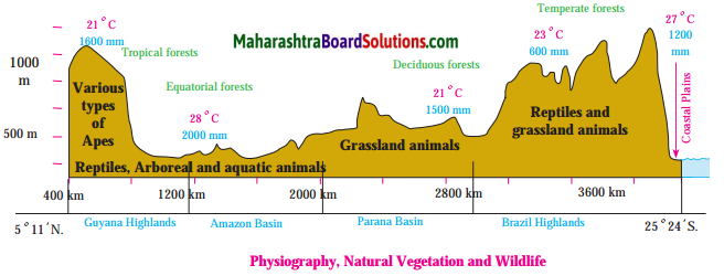
Answer the following questions on the basis of map given:
Maharashtra Board Class 10 Geography Solutions Chapter 5 Natural Vegetation and Wildlife 21
Question 1.
How many mm of rainfall does Tropical forests have?
Answer:
Tropical forests receives rainfall of 1600 mm.

Question 2.
How much rainfall does equatorial forests receive?
Answer:
Equatorial forests receive 2000 mm of rainfall.

Question 3.
Name the types of forests shown in figure.
Answer:
Tropical forests, Equatorial forests, Deciduous forests and Temperate forests are shown in the above figure.

Question 4.
Where are tropical and equatorial forests found in Brazil?
Answer:Tropical and equatorial forests are found in Guyana Highlands and Amazon basin respectively.

Question 5.
Where are deciduous forests and temperate forests found in Brazil?
Answer:
Deciduous forests and Temperate forests are found in Parana Basin and Brazilian Highlands respectively.

Question 6.
What kind of wildlife is seen in Brazilian Highlands?
Answer:
Reptiles and grassland animals are seen in Brazilian Highlands.

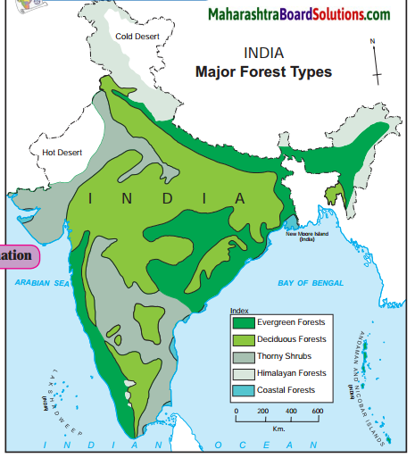
Maharashtra Board Class 10 Geography Solutions Chapter 5 Natural Vegetation and Wildlife 6

Question 1.
Which forests are found in western snow¬capped regions?
Answer:
Himalayan Forests are found in western snow-capped regions.

Question 2.
On which coast do you mainly find the coastal vegetation?
Answer:
The coastal vegetation is mainly found along the Eastern Coast.

Question 3.
Which type of forests occupy maximum area in India ? Why?
Answer:
Deciduous forests are found in the regions receiving rainfall between 1000 mm to 2000 mm Since most of India has rainfall in that range, deciduous forests dominate the Indian subcontinent.

Question 4.
Where do you find thorny and shrub vegetation in India and why?
Answer:
Semi arid areas of Gujarat, Rajasthan, Madhya Pradesh, Chhattisgarh, Uttar Pradesh Maharashtra, Karnataka, Andhra Pradesh, Tamil Nadu and Haryana are the places where thorny and shrub vegetation are found. The thorny forests are found in these regions as the rainfall is less than 500 mm.

Maharashtra Board Class 10 Geography Solutions Chapter 5 Natural Vegetation and Wildlife 7

Maharashtra Board Class 10 Geography Solutions Chapter 5 Natural Vegetation and Wildlife

Question 1.
Name the species shown on the map.
Answer:
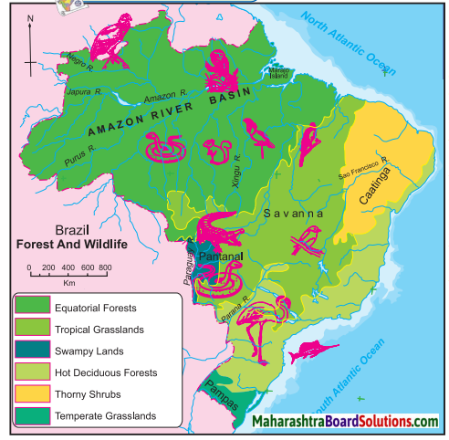
Some of the major species shown on the map are condor, golden lion tamarin, anaconda, crocodile, sword fish, flamingoes, macaw, parrots, rufous bellied thrush.

Question 2.
In which regions are these animals found? Why are their habitats found in these forests?
Answer:

  • The dense equatorial forest region is home to golden lion tamarin, condor, anaconda, etc. This is because these forest lie near the Amazon River and receive rainfall throughout the year.
  • Swampy lands of Pantanal is home to anacondas and crocodiles because these conditions are favourable for their habitation.
  • Sword fish thrives near the South Atlantic Coast due to the extensive continental shelf.

Question 3.
Classify the forest regions in Brazil with reference to their extent.
Answer:

  • Equatorial forests are found in the northern part of Brazil and it covers an extensive area.
  • Tropical Grasslands (Savanna) is the next major forest type occupying central part of Brazil.
  • Hot deciduous forests occupy the southern Brazil whereas swampy lands of Pantanal occupy a small part of Brazil in the south west.
  • Thorny shrubs occupy the north western part of Brazil owing to low rainfall whereas Temperate Grasslands (Pampas) occupy south Brazil.

Mark the following on the map of India with the given information:
Question 1.

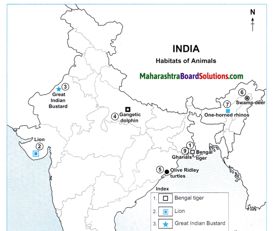
  1. Bengal Tiger
  2. Lion
  3. Great Indian Bustard
  4. Gangetic Dolphin
  5. Olive Ridley turtles
  6. Swamp deers
  7. One-horned rhinos
  8. Nilgiri Tahr goat
  9. Gharials

Answer:
Maharashtra Board Class 10 Geography Solutions Chapter 5 Natural Vegetation and Wildlife 4
Maharashtra Board Class 10 Geography Solutions Chapter 5 Natural Vegetation and Wildlife 5

Class 10 Geography Chapter 5 Natural Vegetation and Wildlife Additional Important Questions and Answers

Choose the correct option and rewrite the statements:

Question 1.
In Brazil, _____ varies due to physiography.
(a) soil
(b) rainfall
(c) agriculture
(d) mineral availability
Answer:
(b) rainfall

Question 2.
In most parts of the _____ region, it rains throughout the year.
(a) temperate
(b) tropical
(c) grasslands
(d) equatorial
Answer:
(d) equatorial

Question 3.
As one moves away from the Equator, _______ decreases.
(a) altitude
(b) forest
(c) rainfall
(d) snowfall
Answer:
(c) rainfall

Maharashtra Board Class 10 Geography Solutions Chapter 5 Natural Vegetation and Wildlife

Question 4.
The _______ forests are found where there is rainfall throughout the year.
(a) tropical
(b) thorny
(c) evergreen
(d) temperate
Answer:
(c) evergreen

Question 5.
Brazil has the/a ______ number of vegetation species in the world.
(a) moderate
(b) largest
(c) low
(d) smallest
Answer:
(b) largest

Question 6.
The rainforests are rightly called the _______.
(a) lungs of the world’
(b) ’limbs of the world’
(c) ’heart of the world’
(d) ’veins of the world’
Answer:
(a) lungs of the world’

Question 7.
Highest biodiversity is found in _____ forests.
(a) thorny
(b) deciduous
(c) evergreen
(d) coastal
Answer:
(c) evergreen

Question 8.
In regions receiving rainfall between 1000 mm to 2000 mm in India, ______ forests are found.
(a) thorny
(b) evergreen
(c) deciduous
(d) tropical
Answer:
(c) deciduous

Question 9.
In regions receiving less than 500 mm of rainfall that experience dry summers for a long time in India, ______ and shrub like vegetation are found.
(a) equatorial
(b) evergreen
(c) grasslands
(d) thorny
Answer:
(d) thorny

Question 10.
In _____ areas, coastal type of vegetation is found.
(a) peninsular
(b) mountainous
(c) rocky
(d) swampy
Answer:
(d) swampy

Question 11.
Coastal type of vegetation is called ____ in India.
(a) Bangar
(b) Sunderbans
(c) Pantanal
(d) Terai
Answer:
(b) Sunderbans

Maharashtra Board Class 10 Geography Solutions Chapter 5 Natural Vegetation and Wildlife

Question 12.
The wood found in Sunderbans is _____ light and durable.
(a) dry
(b) fragile
(c) oily
(d) soft
Answer:
(c) oily

Question 13.
In areas located in the ____ altitude of Himalayas, seasonly flowering trees are found.
(a) highest
(b) lowest
(c) plains
(d) medium
Answer:
(a) highest

Question 14.
In regions with medium altitude of Himalayas, ______ trees are found.
(a) rubber
(b) evergreen
(c) rose wood
(d) coniferous
Answer:
(d) coniferous

Question 15.
At foothills of the Himalayas _____ forests are found.
(a) mixed
(b) teak –
(c) coniferous
(d) pine
Answer:
(a) mixed

Question 16.
The proportion of ________ trees is higher at the foothills of the Himalayas.
(a) sal
(b) deodar
(c) rosewood
(d) pine
Answer:
(a) sal

Question 17.
Teak is mainly found in the _______ type of forest.
(a) Coastal
(b) Thorny and bush
(c) Coniferous
(d) Deciduous
Answer:
(d) Deciduous

Question 18.
A greater diversity of wildlife is found in ________ than any other country in the
world.
(a) India
(b) Russia
(c) Australia
(d) Brazil
Answer:
(d) Brazil

Question 19.
In the swampy areas of Pantanal, _______ are found.
(a) cobras
(b) vipers
(c) huge anacondas
(d) Indian pythons
Answer:
(c) huge anacondas

Question 20.
Among fish varieties, ______ is found in seas of Brazil
(a) mackerel
(b) king fish
(c) sword fish
(d) pink dolphins
Answer:
(c) sword fish

Question 21.
In Brazilian rivers, pink dolphins and ______ are found.
(a) gold fish
(b) piranhas
(c) king fish
(d) mackrels
Answer:
(b) piranhas

Maharashtra Board Class 10 Geography Solutions Chapter 5 Natural Vegetation and Wildlife

Question 22.
One of the major bird species found in Brazil includes _______.
(a) ostrich
(b) flamingoes
(c) kiwi
(d) duck
Answer:
(b) flamingoes

Question 23.
Slash and bum agriculture is also called ______ in Brazil.
(a) kumri
(b) roka (roca)
(c) dry farming
(d) bewar
Answer:
(b) roka (roca)

Question 24.
Hot and humid forests are a home for _______
(a) tiger
(b) elephants
(c) dogs
(d) leopard
Answer:
(b) elephants

Question 25.
One horned rhinoceroses are found in swampy and marshy lands of ______.
(a) Assam
(b) Madhya Pradesh
(c) Telangana
(d) Tamil Nadu
Answer:
(a) Assam

Question 26.
Indian bisons, deers, monkeys are found in the _____ region.
(a) Himalayan
(b) Western Ghats
(c) Peninsular
(d) Deccan
Answer:
(c) Peninsular

Question 27.
The only country where both lions and tigers are found is ______.
(a) Brazil
(b) India
(c) Australia
(d) America
Answer:
(b) India

Question 28.
______ which are huge in size fly high in the Brazilian sky.
(a) Macaws
(b) Kingfishers
(c) Condors
(d) Pheasants
Answer:
(c) Condors

Match the Column:

Question 1.

Column ’A’ Column ‘B’
1. Evergreen Forests (a) Major portion of Madhya Pradesh
2. Deciduous forests (b) Arunachal Pradesh
3. Thorny shrubs (c) Sundarbans
4. Himalayan forests (d) Western Ghats
5. Coastal forests (e) Gujarat
(f) Cold desert in Jammu and Kashmir
(g) Hot desert in Rajasthan

Answer:
1 – d
2 – a
3 – e
4 – b
5 – c

Question 2.

Column ’A’ Column ‘B’
1. Equatorial forests (a) Caatinga
2. Grasslands (b) Pantanal
3. Swampy Lands (c) Pampas
4. Hot deciduous forests (d) Amazon river basin
5. Thorny shrubs (e) Escarpment
(f) Savanna
(g) Parana basin

Answer:
1 – d
2 – c
3 – b
4 – e
5 – a

Maharashtra Board Class 10 Geography Solutions Chapter 5 Natural Vegetation and Wildlife

Identify the odd man out:

Question 1.
With reference to Fauna in India.
(a) Anaconda
(b) Elephants
(c) Lion
(d) Tiger
Answer:
(a) Anaconda

Question 2.
With reference to Flora of Brazil.
(a) Pau Brazil
(b) Rubber
(c) Mahogany
(d) Deodar
Answer:
(d) Deodar

Question 3.
With reference to Himalayan Forests.
(a) Seasonal flowering plants
(b) Orchids
(c) Pine
(d) Mixed Forests
Answer:
(b) Orchids

Question 4.
With reference to birds found in Brazil.
(a) Condors
(b) Flamingoes
(c) Macaws
(d) Peacocks
Answer:
(d) Peacocks

Question 5.
With reference to birds found in India.
(a) Peacock
(b) Kingfisher
(c) Duck
(d) Condors.
Answer:
(d) Condors.

Question 6.
With reference to protection of wildlife, Government of India has setup.
(a) Museums
(b) Biosphere reserves
(c) National Parks
(d) Wildlife sanctuaries
Answer:
(a) Museums

Answer the following questions in one sentence:

Question 1.
Where does it rain throughout the year?
Answer:
It rains throughout the year, in most parts of the equatorial region.

Question 2.
As one moves away from the Equator, does the rainfall increase?
Answer:
No, the rainfall decreases as one moves away from the Equator.

Question 3.
Where are evergreen forests found?
Answer:
Evergreen forests are found in the area where it rains throughout the year.

Question 4.
What effect does rainfall have on vegetation?
Answer:
As the rainfall decreases, the density of the vegetation also decreases.

Question 5.
What kind of vegetation is found in places of less rainfall?
Answer:
Various types of grass, short shrubs and thorny vegetation is found in places of less rainfall.

Maharashtra Board Class 10 Geography Solutions Chapter 5 Natural Vegetation and Wildlife

Question 6.
Where are the largest number of vegetation species found in the world?
Answer:
Brazil has the largest number of vegetation species in the world.

Question 7.
What kind of trees are found in Brazil?
Answer:
Trees like Pau Brasil, rubber, mahogany, rosewood and a variety of orchids are found in Brazil.

Question 8.
Why are the evergreen forests called the ‘lungs of the world’?
Answer:
Evergreen forests are called the lungs of the world because they release large amount of oxygen in the environment which helps to reduce the carbon dioxide levels.

Question 9.
Describe the leaves of trees found in evergreen forests.
Answer:
The leaves of trees found in evergreen forests are broad and green.

Question 10.
What quality of wood is found in evergreen forests?
Answer:
The wood found in evergreen forests is hard, heavy and durable.

Question 11.
In which regions are deciduous forests found?
Answer:
Deciduous forests are found in the regions receiving an average amount of rainfall ranging between 1000mm to 2000mm in India.

Question 12.
Which trees are found in deciduous forests?
Answer:
Trees like teak, bamboo, banyan, peepal, etc. are found in deciduous forest.

Question 13.
Which regions experience dry summers for a long time in India?
Answer:
Regions that receive less than 500 mm of rainfall experience dry summers for a long time in India.

Question 14.
Which kind of vegetation is found in regions receiving less than 500 mm of rainfall?
Answer:
Thorny or shrub like vegetation is found in regions receiving less than 500 mm of rainfall.

Question 15.
How are the leaves of trees in the region where there is less than 500 mm of rainfall?
Answer:
The leaves of trees are small in the region where there is less than 500 mm of rainfall.

Question 16.
Where is coastal vegetation found?
Answer:
Coastal vegetation is found in swampy areas, estuaries and lagoons near coastal areas.

Question 17.
What is coastal vegetation called in India?
Answer:
Coastal vegetation is called mangroves or Sunderbans in India.

Question 18.
How is the wood of trees found in coastal vegetation?
Answer:
The wood of trees found in coastal vegetation is oily, light and durable.

Maharashtra Board Class 10 Geography Solutions Chapter 5 Natural Vegetation and Wildlife

Question 19.
How many types of forests are there in the Himalayas?
Answer:
There are three types of forests in the Himalayas based on their altitude.

Question 20.
Which kind of trees are found in regions of high altitude in the Himalayas?
Answer:
Seasonally flowering trees are found in regions of high altitude.

Question 21.
Which type of trees are found in regions with medium altitude in the Himalayas?
Answer:
In regions with medium altitude, coniferous trees like pine, deodar and fir are found.

Question 22.
Where are mixed forests found in India?
Answer:
Mixed forest are found at the foothills of the Himalayas.

Question 23.
Where is greater diversity in wildlife found in the world?
Answer:
A greater diversity in wildlife is found in Brazil than any other country in the world.

Question 24.
Which animal is found in the swampy areas of the Pantanal?
Answer:
Huge anacondas are found in the swampy areas of Pantanal.

Question 25.
Which are the other animals found in Brazil?
Answer:
Animals like guinea pigs, crocodiles, alligators, monkeys, pumas, leopards, etc. are found in Brazil.

Question 26.
Which is the main variety of fish found in the Brazilian sea?
Answer:
Sword fish is mainly found in the Brazilian sea.

Question 27.
Which varieties of fish are found in the rivers of Brazil?
Answer:
Piranhas are found in the rivers of Brazil.

Question 28.
What kind of birds are seen in the Brazilian sky?
Answer:
Condors, parrots, macaws, and flamingoes are found in the Brazilian skies.

Question 29.
Why is degradation of environment happening in Brazil?
Answer:
Degradation of environment is happening in Brazil due to illegal smuggling of wild animals, slash and bum agriculture (roka), deforestation, and pollution.

Question 30.
Where are elephants found in India?
Answer:
Elephants are found in hot and humid forests of India.

Question 31.
Where are one homed rhinoceroses found?
Answer:
One homed rhinoceroses are found in the swampy and marshy lands of Assam.

Question 32.
Which animals are found in the arid lands of India?
Answer:
Wild ass and camels are found in the arid lands of India.

Question 33.
Which animal is found in the snow capped regions of Himalayas?
Answer:
Snow leopards are found in the snow capped regions of the Himalayas.

Question 34.
Which animals are found in the peninsular region of India?
Answer:
Indian Bisons, deer, antelopes, and monkeys are found in the Peninsular region of India.

Question 35.
Which is the only country where both lions and tigers are found?
Answer:
India is the only country where both lions and tigers are found.

Question 36.
Where are turtles, crocodiles and gharials found in India?
Answer:
Turtles, crocodiles and gharials are found in rivers, estuaries, and coastal areas of India.

Maharashtra Board Class 10 Geography Solutions Chapter 5 Natural Vegetation and Wildlife

Question 37.
Which birds are found in the forests and wetlands of India?
Answer:
Birds like peacocks, Indian bustard, kingfishers, peasants, ducks, parakeet, cranes, and pigeons are found in the forests and wetlands of India.

Question 38.
What measures are taken by the Government of India for the protection of wildlife and forests of India?
Answer:
The Government of India has set up a number of national parks, wildlife sanctuaries, bird sanctuaries, and biosphere reserves for the protection of wildlife and forests in India.

Question 39.
Name some plants found in regions having less than 500 mm of rainfall in India.
Answer:
Catechu, acacia, khejri and a variety of cactus like aloevera and agave are found in regions having less than 500 mm of rainfall in India.

Name the following:

Question 1.
The region where it rains throughout the year.
Answer:
Equatorial region.

Question 2.
The forests which are found where it rains throughout the year.
Answer:
Evergreen forests.

Question 3.
Kind of vegetation found in places of less rainfall.
Answer:
Grass, short shrubs, thorny vegetation.

Question 4.
Country where the largest number of vegetation species in the world is located.
Answer:
Brazil.

Question 5.
The types of trees found in Brazil.
Answer:
Pau Brasil, rubber, mahogany, rosewood and variety of orchids.

Question 6.
Other name for rain forests.
Answer:
‘The lungs of the world.’

Question 7.
Trees found in deciduous forests.
Answer:
Teak, bamboo, banyan, peepal.

Question 8.
Type of vegetation found in regions having less than 500 mm of rainfall.
Answer:
Thorny and shrub-like.

Question 9.
Plants found in regions having less than 500 mm of rainfall.
Answer:
Catechu, acacia, khejri and varieties of cactus.

Question 10.
Kind of vegetation found in swampy areas.
Answer:
Coastal type.

Question 11.
Another name of coastal type of vegetation in India.
Answer:
Mangroves or sunderbans.

Maharashtra Board Class 10 Geography Solutions Chapter 5 Natural Vegetation and Wildlife

Question 12.
Kind of trees found in forests located on higher altitudes in the Himalayas.
Answer:
Seasonally flowering trees.

Question 13.
Kind of trees which have grown in forests located on medium altitudes in Himalayas. Coniferous trees like Pine, Deodar and Fir.
Answer:
Region where mixed forests are found in Himalayas.

Question 14.
Foothills of Himalayas.
Answer:
Animal found in the swampy areas of Pantanal.

Question 15.
Huge anacondas.
Answer:
Any two varieties of animals found in Brazil. Guinea pigs and crocodiles.

Question 16.
Kind of fishes found in seas of Brazil.
Answer:
Sword fish.

Question 17.
Fish varieties found in the rivers of Brazil.
Answer:
Pink dolphins and Piranhas.

Question 18.
Any two species of birds found in Brazil.
Answer:
Condors and macaws.

Question 19.
Causes for degradation of environment.
Answer:
Illegal smuggling of wild animals, roka, deforestation and pollution

Question 20.
Region where elephants are found in India.
Answer:
Hot and humid forests.

Question 21.
Animal which is found in the swampy and marshy lands of Assam.
Answer:
One horned rhinoceroses.

Question 22.
Animals which are found in arid lands of India.
Answer:
Wild ass and camels.

Question 23.
Animals which are found in the snowcapped mountain of Himalayas.
Answer:
Yaks and snow leopards.

Question 24.
Animals found in the Peninsular region of India.
Answer:
Indian bisons, deer, antelopes and monkeys.

Question 25.
Country where both lion and tigers are found.
Answer:
India.

Question 26.
Animals found in rivers, estuaries and coastal areas of India.
Answer:
Turtles, crocodiles and garials.

Question 27.
Measures taken by the Government of India to protect wildlife.
Answer:
Setting up of National parks, bird sanctuaries, wildlife sanctuaries and biosphere reserves.

Question 28.
National animal of India.
Answer:
Tiger.

Maharashtra Board Class 10 Geography Solutions Chapter 5 Natural Vegetation and Wildlife

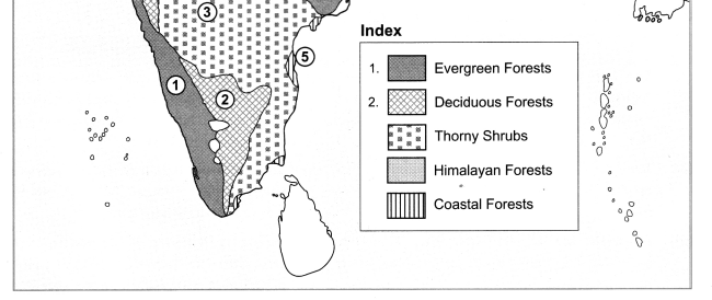
Mark the following on the map of India with the given information:

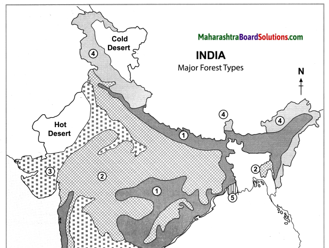
  1. Evergreen forests
  2. Deciduous forest
  3. Thorny shrubs
  4. Himalayan Forests
  5. Coastal Forests

Answer:
Maharashtra Board Class 10 Geography Solutions Chapter 5 Natural Vegetation and Wildlife 13
Maharashtra Board Class 10 Geography Solutions Chapter 5 Natural Vegetation and Wildlife 9

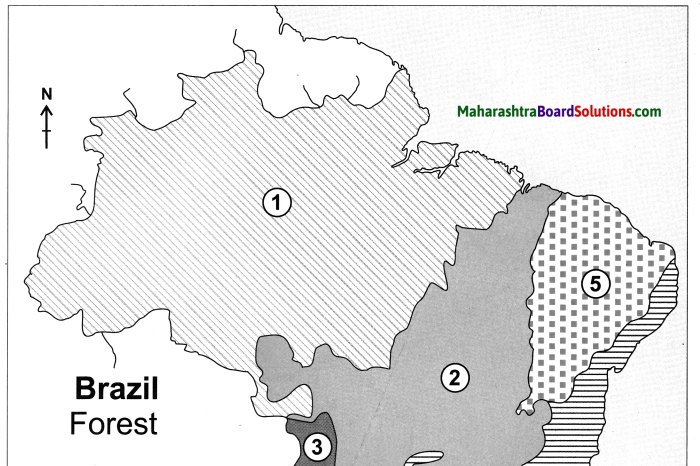
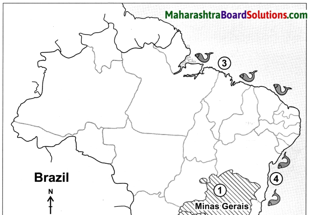
Mark the following on the map of Brazil with the given information:

  1. Equatorial forests
  2. Tropical grasslands
  3. Swampy lands
  4. Hot deciduous forest
  5. Caatinga
  6. Temperate grasslands

Answer:

Maharashtra Board Class 10 Geography Solutions Chapter 5 Natural Vegetation and Wildlife 12
Maharashtra Board Class 10 Geography Solutions Chapter 5 Natural Vegetation and Wildlife 11
Equatorial Forests Tropical Grasslands:Savanna Swampy Lands Hot Deciduous Forest Thorny Shrubs/Caatinga Temperate Grasslands:Pampas

Maharashtra Board Class 10 Geography Solutions Chapter 5 Natural Vegetation and Wildlife

Question 1.
Show the habitats of tigers in India with their names on a map.
Answer:
Maharashtra Board Class 10 Geography Solutions Chapter 5 Natural Vegetation and Wildlife 14
Maharashtra Board Class 10 Geography Solutions Chapter 5 Natural Vegetation and Wildlife 15

Question 2.
Why is their habitat found in these regions?
Answer:
Tiger’s habitats are found in these regions because here there are various types of forest areas with different types of herbivorous animals.

Answer the Questions Briefly:

Question 1.
Thorny and shrub-like vegetation is found in regions where there is less or no rainfall.
Answer:

  • The regions where there is less or no rainfall have a hot and dry climate.
  • The soils in these regions are also rocky and dry.
  • Water evaporation in leaves is more since the surface area of exposure is more than that of thorns
  • Hence, thorny and shrub-like vegetation is found in regions where there is less or no rainfall to conserve water.

Question 2.
The evergreen rainforests in Brazil are rightly called the ‘Lungs of the world’.
Answer:

  • The northern Part of Brazil has dense evergreen forests. .
  • These forests release a large amount of oxygen in the environment.
  • This helps to reduce carbon dioxide levels.
  • Therefore, these rainforests are rightly called the Tungs of the world’.

Question 3.
The largest variety of flora is found in Brazil.
Answer:

  • The flora of any region depends upon the amount of rainfall and its physiography.
  • Brazil has equatorial forests in high rainfall areas, tropical grasslands and deciduous forests in moderate rainfall areas.
  • Western part of Brazil has swampy lands, whereas low rainfall regions have thorny shrubs.
  • Temperate grasslands are found in temperate regions.
  • Thus, the largest variety of flora is found in Brazil.

Question 4.
Suggest measures for the conservation of wildlife and forest in India?
Answer:
Measures for the conservation of wildlife and forest in India are as follows:

  • Restricting wildlife trading and hunting.
  • Declaring more national parks and sanctuaries.
  • Giving more importance to the protection of endangered animals.
  • Controlling felling of trees.
  • Implementing afforestation and social forestry programmes.

Maharashtra Board Class 10 Geography Solutions Chapter 5 Natural Vegetation and Wildlife

Write short notes on:

Question 1.
Brazilian Vegetation:
Answer:
(i) In Brazil, rainfall varies due to physiography. In most parts of the Equatorial region, it rains throughout the year.
(ii) As one moves away from the equator, the number of rainy days as well as amount of rainfall reduces.
(iii) This affects the life cycle of the vegetation too.
(iv) Evergreen forests are found in the areas where it rains throughout the year.
(v) In regions which receive rainfall only during certain seasons, the density of the vegetation reduces.
(vi) Instead of forests, various types of grass, short shrubs,,thorny vegetation, etc. are found.
(vii) Brazil has the largest number of vegetation species in the world.
(viii) This includes evergreen vegetation, semi-evergreen, arid, etc.
(ix) One finds trees like Pau Brasil, rubber, mahogany, rosewood and a variety of orchids.

Question 2.
wildlife of Brazil:
Answer:
(i) A greater diversity in wildlife is found in Brazil compared to any other country in the world.
(ii) In the swampy areas of the Pantanal, huge anacondas are found.
Animals, such as guinea pigs, crocodiles,
alligators, monkeys, pumas, leopards, etc. are found.
(iv) Among the fish varieties, mainly swordfish are found in the seas, while pink dolphins and piranhas are found in the rivers .
(v) Condors which are huge in size and fly high in the sky, various types of parrots, macaws, and flamingoes are the major birds found here.
(vi) Millions of insect varieties are also found here.

Question 3.
The wildlife of India:
Answer:
(i) India is also a mega-diverse country in terms of wildlife. There are many species of wildlife in Irdia.
(ii) Elephants are found in hot and humid forests. One-horned rhinoceroses are found in swampy and marshy lands of Assam.
(iii) Wild ass and camels are found in arid lands. Snow leopards and yaks are found in the snow-capped regions of the Himalayas.
(iv) Indian Bisons, deer, antelopes, and monkeys are found in the Peninsular region.
(v) India is the only country in the world where both tigers and lions are found.
(vi) Rivers, estuaries and coastal areas are homes to many turtles, crocodiles, and gavials (gharials).
(vii) The forests and wetlands are the shelters of variety of birds like peacocks, Indian bustard, kingfishers, pheasants, ducks, parakeets, cranes, and pigeons.

10th Std Geography Questions And Answers:

Human Settlements Question Answer Class 10 Geography Chapter 7 Maharashtra Board

Balbharti Maharashtra State Board Class 10 Geography Solutions Chapter 7 Human Settlements Notes, Textbook Exercise Important Questions and Answers.

Std 10 Geography Chapter 7 Question Answer Human Settlements Maharashtra Board

Class 10 Geography Chapter 7 Human Settlements Question Answer Maharashtra Board

Geography Class 10 Chapter 7 Question Answer Maharashtra Board

1. Tick (✓) the correct options:

Question a.
The concentration of settlements is related to following major factors
(a) Proximity to the Sea
(b) Plain region
(c) Availability of water
(d) Climate
Answer:
(c) Availability of water

Question b.
In North-eastern part of Brazil, which types of settlements are found
(a) Nucleated
(b) Linear
(c) Dispersed
(d) Star-shaped
Answer:
(c) Dispersed

Maharashtra Board Class 10 Geography Solutions Chapter 7 Human Settlements

Question c.
Where do you find dispersed settlements in India?
(i) Near the rivers
(ii) Near the transport routes
(iii) Hilly areas
(iv) Industrial regions
Answer:
(iii) Hilly areas

Question d.
Concentrated settlements are found in Narmada Valley
(i) Forested land
(ii) Cultivable land
(iii) Undulating topography
(iv) Industries
Answer:
(ii) Cultivable land

Question e.
Which state has the least urbanisation in Brazil?
(i) Para
(ii) Amapa
(iii) Espirito Santo
(iv) Parana
Answer:
(i) Para

Maharashtra Board Class 10 Geography Solutions Chapter 7 Human Settlements

2. Give geographical reasons:

Question a.
Availability of water is a major factor affecting settlements.
Answer:
(i) Water is a major factor affecting settlements because water is required for survival of living beings, for purposes like drinking, cooking, agriculture, industries, etc.
(ii) Due to availability of water, agriculture and industries flourish, generating employment opportunities and leading to development of settlements.
(iii) Shortage of water will hamper the growth of agriculture and industries which lead to less development of settlements.

Question b.
In Brazil, majority of population is found in the eastern coastal areas.
Answer:
(i) Although the coastal climate is hot and humid, and flat land is limited due to rugged topography, the eastern coast of Brazil has a good water supply and a large range of natural resources.
(ii) The region has rich fertile soil which is most suitable for coffee cultivation..
(iii) The region is rich in minerals like iron ore and has a steady power supply.
(iv) An excellent transportation facility is also available here.
(v) Due to these factors, agriculture, industries and trade flourish and settlements increase.
So, majority of Brazil’s population is found in the eastern coastal areas.

Question c.
Urbanisation is increasing rapidly in India.
Answer:
(i) In India, there has been growing industrialisation, leading to availability of jobs in urban areas.
(ii) Urban areas have better facilities and amenities like water supply, electricity, health, education, etc.
(iii) There is increasing migration of people from rural areas to urban areas.
(iv) The urban population is increasing due to the expansion of urban centres and emergence of new towns.
So, urbanisation is increasing rapidly in India.

Question d.
Settlements are sparse in north-eastern Brazil.
Answer:
(i) The north east of Brazil is a Highland.
(ii) As this region lies in a rain shadow region it suffers from droughts.
(iii) Due to scanty rainfall and unavailability of resources, agriculture and industries are not well developed.
(iv) Transport facilities are also very poor here. Therefore, settlements are sparse in north – eastern Brazil.

Maharashtra Board Class 10 Geography Solutions Chapter 7 Human Settlements

Question e.
Except Delhi and Chandigarh, urbanisation is low in other parts of India.
Answer:
(i) Delhi and Chandigarh are union territories lying in the flat Northern Plains of India.
(ii) Delhi is the capital of India and has an ancient history of urbanisation while Chandigarh is one of the most well-planned cities.
(iii) Both Delhi and Chandigarh have good water supply due to river Yamuna and the Bhakra Canal.
(iv) As compared to the other cities in North India, both the cities have well-developed infrastructure, good transport links and other amenities.
(v) Fast developing industries and commercial centres in these places, offer high employment opportunities leading to urbanisation.
Hence, except Delhi and Chandigarh, urbanisation is low in other parts of India.

3. Answer in short:

Question a.
Write a comparative note on urbanisation in Brazil and India.
Answer:
(i) Rate of urbanisation in higher in Brazil than in India.
(ii) Growth of urbanisation in India has been slow.
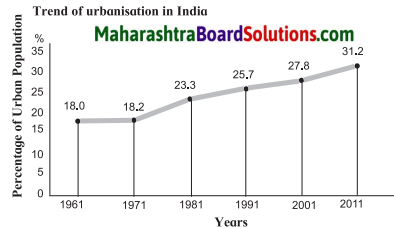
E.g. From 18% in 1961 to 31.2% in 2011.
(iii) Growth of urbanisation in Brazil has been rapid.
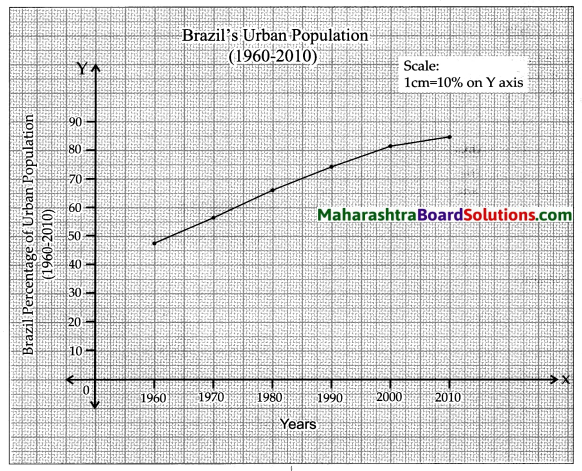
E.g. From 47.1% in 1960 to 84.6% in 2010.
(iv) Urbanisation has been more in the southern part than in the Northern part of India.
(v) Urbanisation in Brazil has been more in the coastal states of south and southeast than the states in the interior of the west and north.
(vi) India’s rate of urbanisation has increased continously in a fluctuating rate.
(vii) Brazil’s is rate of urbanisation has increased but in a diminishing rate.

Question b.
Differentiate between the human settlements in the Ganga river basin and the Amazon river basin.
Answer:

S.No Human settlements in the Ganga river basin Human settlements in the Amazon river basin
(i) Nucleated settlements are found in Ganga river basin. (i) Dispersed settlements are found in Amazon river basin.
(ii) Flat land, availibality of water, fertile soil,favourable climate is suitable for human settlement. (ii) Unfavourable        climate,      heavy      rainfall, inaccessibility makes the Amazon river basin unsuitable for human settlement.
(iii) The above conditions along with a good transport network has helped to flourish agriculture and other industries. (iii) Due to dense evergreen forests and poor transport facility there are restrictions on the use of natural resources, which have affected economic development.

Question c.
Why do human settlements grow in specific locations only?
Answer:
Human settlements depend on various factors like climate, availability of water, slope of the land, level of development.
In India, nucleated human settlements are found in the Ganga River Basin because of flat fertile plains, abundance of water, favourable climate and growth of agriculture and industries. Dispersed settlements are found in Himalayan slopes, eastern and southern Rajasthan because of uneven topography, unfavourable climate and lack of development.

In Brazil, nucleated settlements are found in Sao Paulo and southern coast of Brazil, due to nearness to the ocean, fertile soil, availability of natural minerals like iron ore, steady power supply and good transportation system. Dispersed settlements are found in Northern Brazil due to the inaccessible forests in Amazon river basin, unhealthy climate, limitations on use of natural resources drought region and poor transport connectivity.

Class 10 Geography Chapter 7 Human Settlements Intext Questions and Answers

Geographical Explanation

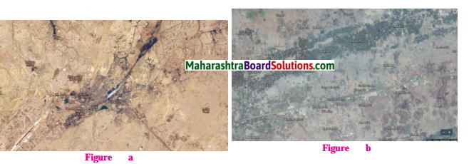
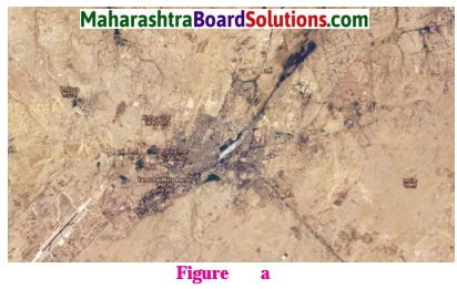
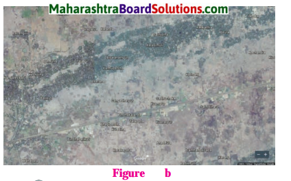
Study the two types of settlement patterns in India given in figure (a) and (b) Answer the following questions :

Maharashtra Board Class 10 Geography Solutions Chapter 7 Human Settlements 1

Maharashtra Board Class 10 Geography Solutions Chapter 7 Human Settlements 2

Question 1.
Identify the type of settlements?
Answer:
Fig a. Settlement Type is: Nucleated and in Fig. b. Settlement Type is: Linear and Dispersed settlement.

Question 2.
Which one is a nucleated settlement? Why?
Answer:
Fig. a. Shows the image of a Nucleated settlement, because it is a cultivated land and has a centrally located water body.

Question 3.
Which one is a dispersed settlement? What could be the reason behind it?
Answer:
In Fig. b. dispersed settlement is observed due to unsuitable topography.

Question 4.
Can you guess in which regions are these settlements located in India?
Answer:
Settlement in Fig. a. is located in the north Indian plain, it might be the river Ganga Basin and settlement in the Fig. b. is located in hilly terrain covered with forest and also a road passing through leads to a dispersed settlement.

Think About It

Question 1.
Tell whether settlements shown in images (a) and (b) are urban or rural.
Maharashtra Board Class 10 Geography Solutions Chapter 7 Human Settlements 11
Maharashtra Board Class 10 Geography Solutions Chapter 7 Human Settlements 12
Answer:
The image shown in (a) is urban and The image shown in (b) is rural

Maharashtra Board Class 10 Geography Solutions Chapter 7 Human Settlements

Lets Recall

Question 1.
Some amenities and facilities are given here. Tick (✓) in the relevant column and complete the table on the basis of their presence in urban and rural areas or both.
Answer:

S.No Amentity Available in Villages Available in Cities
(1) Petrol Pump
(2) Theatre
(3) Weekly Market
(4) Primary Health Centre
(5) Police Outpost
(6) Art Gallery
(7) Gram Panchayat
(8) Agricultural Produce Market Committee (APMC)
(9) Primary School
(10) Senior School
(11) College
(12) Shop
(13) Multi-speciality Hospital
(14) Metro station
(15) Bus station
(16) University

Try This.

Question 1.
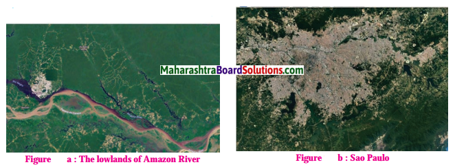
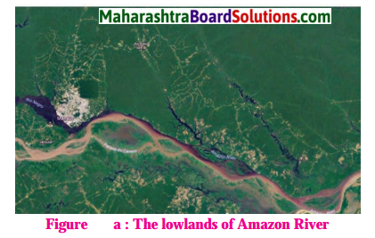
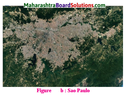
In the figure (a) and (b), you can see images of two settlements in Brazil. One is from the Amazon river basin in Brazil while the other belongs to the coastal area. Observe the settlement patterns carefully and name the types of settlement patterns. Write a comment on their density and types.
Maharashtra Board Class 10 Geography Solutions Chapter 7 Human Settlements 9
Maharashtra Board Class 10 Geography Solutions Chapter 7 Human Settlements 10
Answer:
(1) Fig. (a)
Type settlement pattern: Dispersed settlements as they are lying in the dense forested areas of the Amazon Basin.
Density of Population: Sparse.
(2) Fig. (b)
Type settlement pattern: Nucleated settlements as they are lying in the dense forested areas of the Amazon Basin.
Density of Population: Dense.

Can You Tell

Read the graph below and answer the following questions:
Maharashtra Board Class 10 Geography Solutions Chapter 7 Human Settlements 3
Question 1.
What was the percentage of urbanisation in 1961?
Answer:
The percentage of urbanisation in 1961 was 18%.

Question 2.
In which decade was urbanisation the highest?
Answer:
Highest urbanisation took place in the decade 1971 -1981.

Question 3.
In which decade was the growth of urbanisation lowest?
Answer:
The growth of urbanisation was lowest in the decade 1961-1971.

Question 4.
What was the growth in the percentage of urbanisation between 1961 and 1971?
Answer:
The growth in the percentage of urbanisation between 1961 and 1971 was of 0.20%

Maharashtra Board Class 10 Geography Solutions Chapter 7 Human Settlements

Question 5.
What was the growth in the percentage of urbanisation between 1991 and 2011?
Answer:
The growth in the percentage of urbanisation between 1991 and 2011 was of 5.5%.

Question 6.
What inference can you draw regarding India’s urbanisation after reading the graph?
Answer:
After reading the graph, we can say that urbanisation in India is slowly but continuously rising.

Try This

Look at the table. It shows the growth and share of urban population in total population of Brazil. Draw a line graph from this table. Examine the graph carefully and answer the following questions:
Brazil Percentage of urban population (1960 to 2010)
Maharashtra Board Class 10 Geography Solutions Chapter 7 Human Settlements 4
Answer:
Maharashtra Board Class 10 Geography Solutions Chapter 7 Human Settlements 5

Question 1.
What is the interval of the data?
Answer:
The interval of the data is 10 years.

Question 2.
In which period did urbanisation occur rapidly?
Answer:
Urbanisation occured rapidly in the period 1960 – 1970.

Maharashtra Board Class 10 Geography Solutions Chapter 7 Human Settlements

Question 3.
Write five sentences analysing the graph.
Answer:
(i) The graph shows the percentage of urbanisation in Brazil from 1960 to 2010.
(ii) The interval of the data is 10 years.
(iii) Clearly there has been a rapid urbanisation in Brazil.
(iv) The highest urbanisation is seen between 1960 to 1970, when urbanisation grew from 47.1% to 56.8%, a growth of 9.7%.
(v) Urbanisation occurred slowly during the decade from 2000 to 2010, at a growth of 3.1%.

Give It a Try

Question 1.
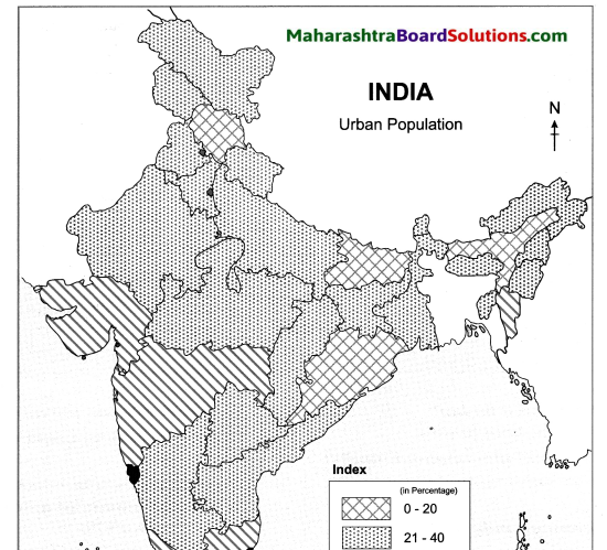
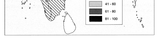
Prepare a choropleth map showing urban population using the data given in the table below.

S.No. Urban population percentage category States /UTs falling in the category
(1) 0-20 Himachal Pradesh, Bihar, Assam and Odisha
(2) 21-40 Meghalaya, Uttar Pradesh, Arunachal Pradesh, Chhattisgarh, Jharkhand, Rajasthan, Sikkim, Tripura, Jammu and Kashmir, Nagaland, Manipur, Uttarakhand, West Bengal, Andhra Pradesh, Haryana, A and N Islands, Punjab, Karnataka and M. P.
(3) 41-60 Gujarat, Maharashtra, Dadra and Nagar Haveli, Kerala, Tamil Nadu, Mizoram
(4) 61-80 Goa, Puducherry, Daman and Diu, Lakshadweep
(5) 81 -100 Chandigarh, NCT of Delhi

Answer:
Maharashtra Board Class 10 Geography Solutions Chapter 7 Human Settlements 6
Maharashtra Board Class 10 Geography Solutions Chapter 7 Human Settlements 7

Colours Of Both

Question 1.
Compare the line graph shown in figure and the one drawn by you for Brazil. Write five lines on the changes that have occurred in urbanisation in both the countries, with time.
Maharashtra Board Class 10 Geography Solutions Chapter 7 Human Settlements 3
Answer:
(i) After comparing the graphs of India and Brazil, it is clear that urbanisation in Brazil has been much more rapid as compared to India.

(ii) Urbanisation in Brazil grew from 47.1% in 1960¬70 to 84.6% in 2000-2010. Whereas urbanisation in India grew from 18% in 1961-70 to 31.2% in 2001-2011.

(iii) But Brazil’s rate of urbanisation is showing signs of decline, whereas India’s rate of urbanisation is showing a slow and consistent growth.

(iv) For e.g. the rate of urbanisation in Brazil has decreased from 9.7% in 1960-1970 to 3.1% in 2000¬2010. Whereas the rate of urbanisation in India has increased from 0.2% in 1961-1971 to 3.4% in 2001-2011.

(v) Both Brazil and India are developing countries, but Brazil shows very high urbanisation as compared to India.

Question 2.
Make a short note on the comparison between the settlement patterns in India and Brazil on the basis of the following points:
(i) Location
(ii) Pattern
(iii) Types
(iv) Density
Answer:
India settlement pattern
Maharashtra Board Class 10 Geography Solutions Chapter 7 Human Settlements 11

  • Location : Nucleated settlements are found throughout the plateau region of Narmada Valley, paddy lands in Bihar, U.P, Vindhyan Plateau and several other cultivated parts of India.
  • Pattern : Nucleated settlements
  • Types: Urban
  •  Density : High population density

Maharashtra Board Class 10 Geography Solutions Chapter 7 Human Settlements 12

  • Location : Dispersed settlements are found in tribal parts covering central part of India, eastern and southern Rajasthan, Himalayan slopes and land with dissected and uneven topography.
  • Pattern : Dispersed settlements
  • Types: Rural
  • Density : Low population density.

Brazilian settlement pattern
Maharashtra Board Class 10 Geography Solutions Chapter 7 Human Settlements 9

  • Location: The Southern and South Eastern parts of Brazil – Areas where there is good water supply, a large range of natural resources, rich soil, large supply of natural minerals, steady energy supply, a good transport system, etc.
  • Pattern : Nucleated settlement
  • Types: Urban
  • Density : High population density.

Maharashtra Board Class 10 Geography Solutions Chapter 7 Human Settlements 10

  • Location : Brazilian Highlands, Central part, Amazon Basin region : regions with dense forests, unfavourable climate, poor transport limits, limitations on the use and exploitation of natural resources, etc.
  • Pattern : Dispersed settlements
  • Type : Rural
  • Density: Low population density

Maharashtra Board Class 10 Geography Solutions Chapter 7 Human Settlements

Give It a Try

Question 1.
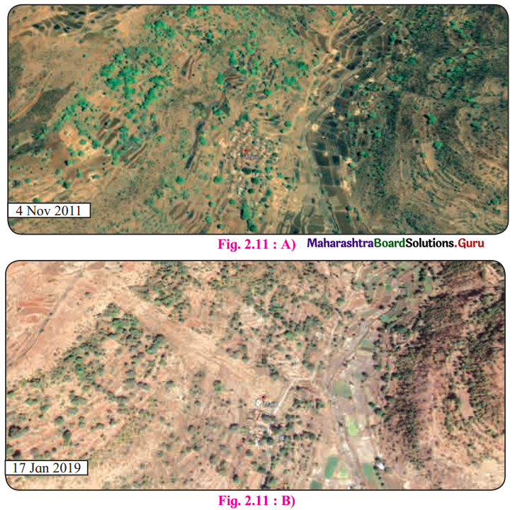
“Observe the two satellite images given below. Describe the settlements with respect to physiography, Considering the physiography, where could these settllements be located? Find out their settlement pattern and limitations with respect to their future growth.
Answer:
(i) Location : Both satellite images show human settlements in a mountainous region. One settlement is along mountain slope, while the other is on top of a mountain.
(ii) Pattern : Dispersed settlements.
(iii) Future growth : Further growth for human settlements seems difficult. This is mainly because of the hilly terrain and forested land along the mountain slope.

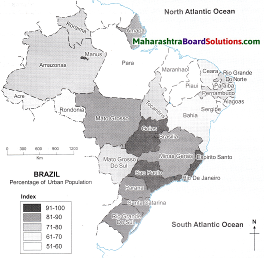
Study the choropleth map of Brazil showing the Statewise urban population of Brazil and answer the following questions :
Maharashtra Board Class 10 Geography Solutions Chapter 7 Human Settlements 8
Question 1.
Which state (region) in Brazil is the most urbanised?
Answer:
The states of Sao Paulo, Rio de Janeiro, Goias, Espirito Santo in the southeastern part of Brazil and the port Manaus in the north are the most urbanised.

Maharashtra Board Class 10 Geography Solutions Chapter 7 Human Settlements

Question 2.
Which state (region) in the least urbanised?
Answer:
The states of Para, Maranhao and Piaui in northern part of Brazil are the least urbanised states.

Use Your Brain Power

Question 1.
Which factors have affected urbanisation in Brazil?
Answer:
(i) In Brazil, rapid urbanisation has taken place in South and South East Coastal regions.
(ii) Being in proximity to the Atlantic Ocean have benefitted these regions immensely in the form of mild climatic conditions.
(iii) Availability of water, fertile soil, natural minerals such as iron ore, good transport system and steady electric supply have positively impacted urbanisation in these parts.
(iv) To the north of the Brazilian Highlands is the rain shadow region of ‘Drought Quadrilateral’ with sparse settlements.

Colours Of Both

Question 1.
Write a paragraph on the settlement pattern, urban and rural settlement and urbanisation in India and Brazil.
Answer:

India settlement pattern
Maharashtra Board Class 10 Geography Solutions Chapter 7 Human Settlements 11

  • Location : Nucleated settlements are found throughout the plateau region of Narmada Valley, paddy lands in Bihar, U.P, Vindhyan Plateau and several other cultivated parts of India.
  • Pattern : Nucleated settlements
  • Types: Urban
  •  Density : High population density

Maharashtra Board Class 10 Geography Solutions Chapter 7 Human Settlements 12

  • Location : Dispersed settlements are found in tribal parts covering central part of India, eastern and southern Rajasthan, Himalayan slopes and land with dissected and uneven topography.
  • Pattern : Dispersed settlements
  • Types: Rural
  • Density : Low population density.

Brazilian settlement pattern
Maharashtra Board Class 10 Geography Solutions Chapter 7 Human Settlements 9

  • Location: The Southern and South Eastern parts of Brazil – Areas where there is good water supply, a large range of natural resources, rich soil, large supply of natural minerals, steady energy supply, a good transport system, etc.
  • Pattern : Nucleated settlement
  • Types: Urban
  • Density : High population density.

Maharashtra Board Class 10 Geography Solutions Chapter 7 Human Settlements 10

  • Location : Brazilian Highlands, Central part, Amazon Basin region : regions with dense forests, unfavourable climate, poor transport limits, limitations on the use and exploitation of natural resources, etc.
  • Pattern : Dispersed settlements
  • Type : Rural
  • Density: Low population density

Maharashtra Board Class 10 Geography Solutions Chapter 7 Human Settlements

Class 10 Geography Chapter 7 Human Settlements Additional Important Questions and Answers

Choose the correct option and rewrite the statements.

Question 1.
_______ settlements are found in tribal parts covering central part of India.
(a) Nucleated
(b) Linear
(c) Dispersed
(d) Circular
Answer:
(c) Dispersed

Question 2.
The earlier settlements in Brazil were formed by settlers from _______ mainly in coastal areas.
(a) Africa
(b) Asia
(c) Europe
(d) Australia
Answer:
(c) Europe

Question 3.
Sao paulo has _________ settlements.
(a) isolated
(b) nucleated
(c) scattered
(d) dispersed
Answer:
(b) nucleated

Question 4.
Rural areas of Brazil such as the north east highlands suffer from _____ which make it difficult for practising agriculture.
(a) high rainfall
(b) extreme cold
(c) extreme droughts
(d) extreme heat
Answer:
(c) extreme droughts

Question 5.
Settlements become _____ as we go to the central part of Brazil.
(a) sparse
(b) dense
(c) nucleated
(d) triangular
Answer:
(a) sparse

Question 6.
The growth of urbanisation in India has been ________.
(a) quick
(b) moderate
(c) slow
(d) rapid
Answer:
(c) slow

Question 7.
In India, urbanisation has been more in the _______ part.
(a) Western
(b) Eastern
(c) Northern
(d) Southern
Answer:
(d) Southern

Maharashtra Board Class 10 Geography Solutions Chapter 7 Human Settlements

Question 8.
Goa is the most urbanised state in India with _______ urban population.
(a) 92%
(b) 52%
(c) 62%
(d) 82%
Answer:
(c) 62%

Question 9.
_____ is more than 80% urban.
(a) Goa
(b) Gujarat
(c) Delhi
(d) Puducherry
Answer:
(c) Delhi

Question 10.
Today, about ______ of Brazil’s population lives in urban area.
(a) 96%
(b) 66%
(c) 86%
(d) 76%
Answer:
(c) 86%

Question 11.
Looking at the growth in a few parts of the country, the government is promoting “Go _______ ” policy which reduces pressure on other densely populated areas.
(a) East
(b) North
(c) South
(d) West
Answer:
(d) West

Question 12.
Urbanisation has occurred more in the _______ states, in Brazil.
(a) inland
(b) coastal
(c) central
(d) north-western
(b) coastal

Question 13.
_________ is a port on the confluence of the Negro and the Amazon rivers, where urbanisation has occurred.
(a) Alagoas
(b) Parana
(c) Manaus
(d) Ceara
(c) Manaus

Find out the correct group :

Question 1.
States of Brazil in having 91% to 100% urban population.
(a) Sao Paulo, Goias, Espirito Santo and Tocantins.
(b) Espirito Santo, Rio De Janeiro, Para and Goias.
(c) Espirito Santo, Goias, Sao Paulo, Rio De Janeiro.
(d) Sao Paulo, Amapa, Santa Catarina, and Rondonia.
Answer:
(c) Espirito Santo, Goias, Sao Paulo and Rio De Janeiro.

Question 2.
States of India having less than 20% of Urbanization.
(a) Meghalaya, Uttar Pradesh, Arunachal Pradesh and Rajasthan. .
(b) Lakshadweep, Daman and Diu, Puducherry and Nagaland.
(c) Tamil Nadu, Mizoram, Gujarat and Maharashtra.
(d) Odisha, Assam, Bihar and Himachal Pradesh.
Answer:
(d) Odisha, Assam, Bihar, Himachal Pradesh.

Maharashtra Board Class 10 Geography Solutions Chapter 7 Human Settlements

Question 3.
Nucleated settlements in India.
(a) Vindhyan plateau, Plateau region of Narmada valley, Paddy lands in Bihar and Uttar Pradesh.
(b) Rajasthan, Sikkim, Arunachal Pradesh, and Punjab.
(c) Himalayan slopes, East Rajasthan, Tribal part of Madhya Pradesh and Nagaland.
(d) Vindhyan plateau, Paddy lands in Uttar Pradesh, Land with dissected topography and Bihar.
Answer:
(a) Vindhyan plateau, Plateau region of Narmada valley, Paddy lands in Bihar and Uttar Pradesh.

Question 4.
Dispersed settlements in India.
(a) West coast, West Rajasthan, Paddy lands of Punjab and Mizoram.
(b) Land with dissected topography, South Rajasthan, Vindhya plateau and Uttar Pradesh.
(c) Tribal part of Madhya Pradesh, Himalayan slopes, West and South Rajasthan and Land with the uneven topography.
(d) Himalayan slopes, Narmada Valley, West Rajasthan and South India.
Answer:
(c) Tribal part of Madhya Pradesh, Himalayan slopes, West and South Rajasthan and Land with the uneven topography.

Question 5.
States of India having urbanization between 41% to 60%.
(a) Chandigarh, Daman and Diu, Gujarat and Uttar Pradesh.
(b) Maharashtra, Kerala, Gujarat and Mizoram.
(c) Jharkhand, Karnataka, Maharashtra and Goa.
(d) Andhra Pradesh, West Bengal and Uttarakhand, Assam.
Answer:
(b) Maharashtra, Kerala, Gujarat, Mizoram.

Question 1.
Match the columns:

Column ‘A’ Column ‘B’
(1) Most urbanised state in India (a) Sao Paulo
(2) Most urbanised state in Brazil (b) Goa
(3) Least urbanised state in India (c) Mato Grosso
(4) Least urbanised (d) Himachal Pradesh
state in Brazil (e) Delhi
(f) Para

Answer:
1 – b
2 – a
3 – d
4 – f

Are the sentences right or wrong?

Question 1.
India does not have a great tradition of urbanisation.
Answer:
Wrong.

Maharashtra Board Class 10 Geography Solutions Chapter 7 Human Settlements

Question 2.
The earlier settlements in Brazil were formed by the settlers from America.
Answer:
Wrong.

Question 3.
North-East Highlands of Brazil suffer from extreme drought.
Answer:
Right.

Question 4.
The growth of urbanisation in India has been very fast, reaching 86% in 2011.
Answer:
Wrong.

Question 5.
In underdeveloped countries, the rate of urbanisation is low.
Answer:
Right.

Give geographical reasons:

Question 1.
Sao Paulo area has nucleated settlements.
Answer:
(i) Sao Paulo is situated in South East coast of Brazil.
(ii) The region has a good water supply.
(iii) It an extensive area under rich fertile soil which is ideal for growing coffee.
(iv) It has a large supply of natural minerals, such as iron ore.
(v) It also has a steady energy supply.
(vi) This region has a good transport system too.
So, Sao Paulo area has nucleated settlements.

Question 2.
The Brazilian government is promoting ‘Go West’ policy.
Answer:
(i) Brazil is one of the few developing countries which is highly urbanised.
(ii) But urbanisation in Brazil is confined to South and South East.
(iii) For e.g. States like Sao Paulo, Goias, Minas Gerais, Rio De Janeiro have very high urban population.
(iv) Western Brazil continues to remain least urbanised, which is creating regional imbalance.
(v) In order to reduce regional imbalance, the Brazil Government is promoting ‘Go-West Policy’.

10th Std Geography Questions And Answers:

Tourism, Transport and Communication Question Answer Class 10 Geography Chapter 9 Maharashtra Board

Balbharti Maharashtra State Board Class 10 Geography Solutions Chapter 9 Tourism, Transport and Communication Notes, Textbook Exercise Important Questions and Answers.

Std 10 Geography Chapter 9 Question Answer Tourism, Transport and Communication Maharashtra Board

Class 10 Geography Chapter 9 Tourism, Transport and Communication Question Answer Maharashtra Board

Geography Class 10 Chapter 9 Question Answer Maharashtra Board

1. State whether right or wrong with reasons.

Question a.
The future of tourism is bright in India due to its natural diversity.
Answer:
Right.

Question b.
Tourism is an invisible trade.
Answer:
Right.

Maharashtra Board Class 10 Geography Solutions Chapter 9 Tourism, Transport and Communication

Question c.
The indicator of development in a country is the development of transport in that country.
Answer:
Right

Question d.
Brazil’s time is ahead of India’s time.
Answer:
Wrong

Question 5.
The development of tourism in India has begun recently.
Answer:
Right.

2. Answer in short:

Question a.
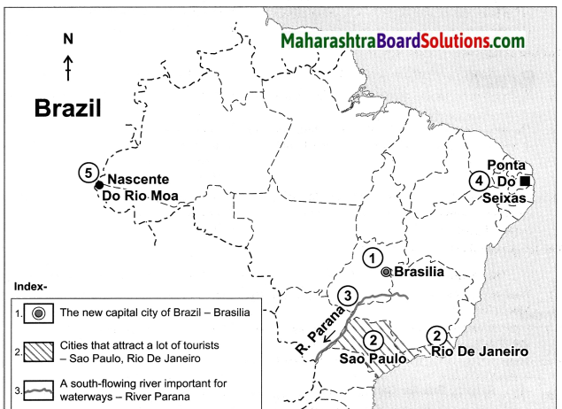
Which factors attract more tourists in Brazil?
Answer:
The factors which attract more tourists in Brazil are:

  • Clean, white sand beaches
  • Attractive seacoasts
  • Beautiful islands
  • Beautiful orchards
  • Deep dense forests of Amazon
  • Various birds and animals
  • Cities like the new capital city of Brasilia, Rio-de- Janeiro and Sao Paulo.
  • Eco-tourism

Question b.
What are the difficulties in the development of the railway system in Brazil’s internal areas?
Answer:

  • The densely forested lands of Amazon River Basin and the swampy lands have limited the development of railways in Brazil.
  • Large pockets of Brazil are unpopulated. Roadways are the most common mode of transportation in the Eastern part of Brazil and waterways have developed on a commercial basis in the Amazon River.
  • The trains are used for long distance transportation of passengers only in a few cities and by tourists. These are the difficulties in the development of the railway system in Brazil’s internal areas.

Maharashtra Board Class 10 Geography Solutions Chapter 9 Tourism, Transport and Communication

Question 3.
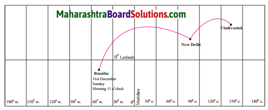
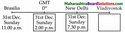
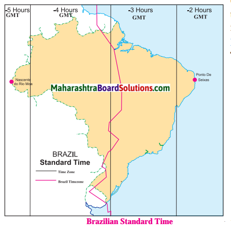
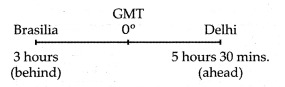
A plane leaves Brasilia at 11 a.m. on 31st December. The plane crosses 0° Meridian and reaches Vladivostok via New Delhi. Tell the local time, date and day at New Delhi and Vladivostok when the plane leaves Brasilia.
Maharashtra Board Class 10 Geography Solutions Chapter 9 Tourism, Transport and Communication 1
Answer:
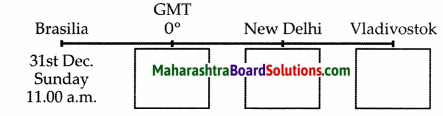
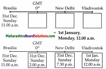
Maharashtra Board Class 10 Geography Solutions Chapter 9 Tourism, Transport and Communication 2
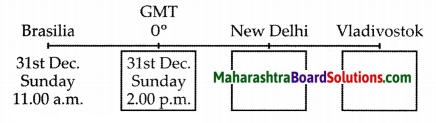
Time difference between Brasilia and GMT = 3 hours
Time at GMT = 11 a.m.+3 hours
= 2.00p.m.

Maharashtra Board Class 10 Geography Solutions Chapter 9 Tourism, Transport and Communication 3
Time difference between GMT and New Delhi = 5 hours 30 min.
Time at New Delhi = 2 a.m. + 5 hours 30 min.
= 7 hours 30 min.
= 31st December,
Sunday, 7.30 p.m.

Maharashtra Board Class 10 Geography Solutions Chapter 9 Tourism, Transport and Communication 4
Time difference between
New Delhi and Vladivostok = 4 hours 30 min.
Time at Vladivostok = 7.30 p.m. + 4 hours 30 min.
= 12.00 am

Maharashtra Board Class 10 Geography Solutions Chapter 9 Tourism, Transport and Communication 5
The local time, date and day at Delhi are 7 : 30p.m. , 31st December, Sunday
local time, date and day at Vladivostok are 12 am. , 1st January, Monday.

4. Match the following:

Column A’ Column ’B’
(1)  Trans-Amazonian
(2) Road Transport
(3)  Rio de Janeiro
(4) Manmad
(a)       Tourist  Place Highway
(b)      Railway Station in India
(c)       Golden Quadrilateral
(d)      Major Highway
(e)       40° W Meridian

Answer:
1 – d
2 – c
3 – a
4 – b

5. Give geographical reasons:

Question a.
Eco-tourism is being developed more in Brazil.
Answer:

  • Eco-tourism means responsible travel to natural areas without causing damage to the environment.
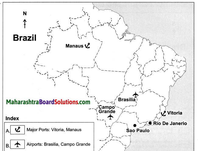
  • Brazil has the largest number of vegetation species in the world including Amazon, the largest rainforest of the world and a great diversity of wild life.
  • It has clean white sand beaches, attractive seacoasts, beautiful islands and orchards. Looking at the sensitivity of the natural resources in Brazil, ecotourism is being developed here.

Maharashtra Board Class 10 Geography Solutions Chapter 9 Tourism, Transport and Communication

Question b.
The internal waterways are not developed in Brazil.
Answer:

  • Most of the rivers in Brazil flow with high speed.
  • The amount of discharge of many rivers is very huge.
  • In Brazil, rigid topography is found at many places near river basins. Many of the areas near rivers are inaccessible.
  • Therefore, internal waterways are not developed in Brazil.

Question c.
A dense network of railways has developed in the North Indian Plains.
Answer:

  • The North Indian Plains are flat plain lands with a dense population.
  • Due to agricultural development, many agro- based industries have developed here.
  • Thus there is a high demand for transportation especially railways for movement of freight and passenger transport.

Question d.
Development of transport is important for the country’s progress.
Answer:

  • Transport modes help is the movement of humans, animals and goods from one location to another.
  • Transport enables social, economic and cultural development of the country.
  • Road transport facilitates door-to-door service.
  • Rail transport is suitable for long distance and bulky goods.
  • Water transport plays an important role in international trade and suitable for bulky goods.
  • Air transport provides the fastest means of transportation.

Question e.
We rely on the sea routes for international trade.
Answer:

  • Waterways is the cheapest modes of transportation for bulky and perishable goods over long distances.
  • International trade includes import and export of goods.
  • India is surrounded by Bay of Bengal, Arabian Sea and India Ocean, therefore we have a long coastline.
  • So we rely on the sea routes for international trade.

Maharashtra Board Class 10 Geography Solutions Chapter 9 Tourism, Transport and Communication

6. Differentiate between:

Question a.
Water transport in the Amazon and the Ganga river.
Answer:

Water transport in the Amazon River Water Transport in the Ganga River
(i) River Amazon is navigable throughout its course due to its gentle slope.
(ii) Boats ply from Equitos in Peru to its mouth i.e., approximately 3700 km.
(iii) River Amazon is used for navigation between Brazil and neighbouring countries.
(i) River Ganga is navigable only in its middle and lower course which is gentler as compared to its upper course.
(ii) Boats ply from Allahabad to Haldia. i.e. approximately 1620 km.
(iii) River Ganga is used for inland transportation.

Question b.
Communication in Brazil and India
Answer:

Communication in Brazil Communication in India
(i) Telecommunication services in Brazil are well developed and efficient.
(ii) Brazil is developing technology to send domestically-made satellites into space with its own rockets.
(i) With the explosion of electronic media, telecommunication industry has become one of the fast growing sectors.
(ii) With development of our own satellites, India has come a long way in this field.

Question c.
IST and BRT
Answer:

IST BRT
(i) 1ST is the Indian Standard Time. (i) BRT is the Brasilia Time/Brazil Time. (Standard Time)
(ii) India has only one standard time zone. (ii) Brazil has four time zones.
(iii) The official 1ST is based on 82.5° E longitude (iii) The official BRT is GMT – 03 which passes
which passes through Allahabad, Uttar Pradesh. through Brasilia.
(iv) 1ST is 5hrs 30mins ahead of Greenwich Meridian (iv) BRT is 2,3,4, or 5 hrs behind Greenwich Meridian
(v) Time as India is in the eastern hemisphere. (v) Time as Brazil is in the western hemisphere.

7. Write short notes on:

Question a.
Modem means of communication:
Answer:
(i) Modern means of communication includes landlines as well as mobile services, television broadcasting and computer/internet access.
(ii) In this era of information and communication technology, digitally enhanced communication devices like mobile phones, smart phones, internet and satellites are being used.

Question b.
Air transport in India:
Answer:
(i) Air transport is more developed in India as compared to Brazil.
(ii) The use of international and internal airways is increasing.
(iii) Important airports from where domestic and foreign travel take place are Mumbai, Delhi, Kolkata, Chennai, Bengaluru, etc.

Question c.
Correlation between physiography and internal waterways:
Answer:
(i) Internal (Inland) waterways comprises of rivers, canals, backwaters, creeks, etc. which are the cheap means of transportation.
(ii) Deep waters, gentle slopes, absence of rapids and waterfalls and the long course of rivers are favourable factors for development of internal waterways.
(iii) The longest waterways in the world is developed in the Amazon river in Brazil which is navigable for around 3700 kms.
(iv) Perennial river like Ganga in India is navigable in its lower course but the peninsular rivers are not used due to shallow waters, shorter course, seasonal nature, etc.

Question d.
Importance of Standard Time:
Answer:
(i) Standard Time is the official time and is commonly accepted all over the country or region.
(ii) The importance of Standard Time is the most, if the country has a vast longitudinal extent, since there will be a great difference between the time of its places located in the eastern and the western parts.
(iii) It helps in making proper schedules of travel, business meeting, co-ordinating the functioning of various organisations, etc.
(iv) Thus Standard Time helps in avoiding confusion regarding day, date and time.

Class 10 Geography Chapter 9 Tourism, Transport and Communication Intext Questions and Answers

Answer the following questions on the basis of the map given.

Observe the map carefully and answer the following questions:
Maharashtra Board Class 10 Geography Solutions Chapter 9 Tourism, Transport and Communication 9
Maharashtra Board Class 10 Geography Solutions Chapter 9 Tourism, Transport and Communication 10
Question 1.
Name the terminal points of the North-South Corridor of Golden quadrilateral Highway.
Answer:
North – Srinagar, South – Kanyakumari.

Question 2.
Name the terminal points of East-West corridor Golden Quadrilateral highway.
Answer:
East – Silchar ; West – Porbandar.

Maharashtra Board Class 10 Geography Solutions Chapter 9 Tourism, Transport and Communication

Question 3.
Name the three major ports on the western coast.
Answer:
Porbandar, Mumbai and Cochin are the three major ports on the western coast.

Question 4.
Name the three major ports on the eastern coast.
Answer:

  1. Chennai
  2. Vishakhapatnam and
  3. Haldia

Question 5.
(Kolkata) are the three major ports on the eastern coast. Which parts of India have a spare network of road transport route? Give reason.
Answer:
The northernmost part of India in the state of Jammu and Kashmir does not have any national highway or other roadways, because it is a mountainous region.

Observe the given map carefully and answer the following questions:

Maharashtra Board Class 10 Geography Solutions Chapter 9 Tourism, Transport and Communication 11

Question 1.
What does the map indicate ?
Answer:
The map indicates the important railway routes and airports of India.

Question 2.
Which part of India has many airports compared to the others?
Answer:
The Southern part of India (i.e.) Peninsular India has many airports compared to the other parts of India.

Question 3.
Which part of India has a dense network of rail routes?
Answer:
North Indian plains region has a dense network of rail routes.

Question 4.
Name the northernmost important railway station.
Answer:
Baramulla is the northernmost important railway station.

Question 5.
Name the easternmost important railway station.
Answer:
Tinsukia is the easternmost important railway station.

Question 6.
Name the two westernmost important railway stations.
Answer:
Okha and Naliya are the two westernmost important railway stations.

Maharashtra Board Class 10 Geography Solutions Chapter 9 Tourism, Transport and Communication

Try this

Look at the graph and answer the following questions:
Maharashtra Board Class 10 Geography Solutions Chapter 9 Tourism, Transport and Communication 6

Question 1.
Which country attracted more international tourists in the year 1995?
Answer:
India attracted more international tourists in the year 1995.

Question 2.
In which country did more international tourists arrive in the year 2000?
Answer:
More international tourists arrived in Brazil in the year 2000.

Question 3.
In which year can an increase be seen in the number of international tourists in India?
Answer:
An increase in the number of international tourists in India can be seen from the year 2010.

Question 4.
What was the number of international tourists in the year 2015 in both the countries? What was the difference between them?
Answer:
The number of international tourists in India in 2015 was approximately 130 lakhs. The number of international tourists in Brazil in 2015 was 60 lakhs. The difference between India and Brazil in the numbers of international tourists in 2015 was 70 lakh people. (130 lakhs – 60 lakhs).

Question 5.
What could be the reason of increase in tourists in India after the year 2010?
Answer:
There is an increase in tourists coming to India after 2010 because :

  • Different types of tourism like eco-tourism, health tourism, business tourism, etc. have been promoted by the Indian Government.
  • The quality of travel and stay in India has also improved.

Question 6.
Name the kind of graph shown above.
Answer:
Polyline graph.

Can you tell ?

Look at the graph and answer the following questions:
Maharashtra Board Class 10 Geography Solutions Chapter 9 Tourism, Transport and Communication 7

Question 1.
What type of graph is shown here?
Answer:
The type of graph shown here is a Joint Bar Graph.

Question 2.
What does the graph show?
Answer:
The graph shows:

  • The percentage of population engaged in tourism in Brazil and India in 2016.
  • The contribution of tourism in GDP by both the countries in 2016.

Maharashtra Board Class 10 Geography Solutions Chapter 9 Tourism, Transport and Communication

Question 3.
Which country’s tourism has a larger share in the contribution towards GDP?
Answer:
Brazil’s tourism has a larger share in the contribution towards GDP.

Question 4.
Which country has a larger population engaged in tourism sector but contributes lesser in GDP?
Answer:
India has a larger population engaged in tourism sector but contributes lesser in GDP terms.

Question 5.
How much percentage of India’s population is engaged in tourism?
Answer:
Nearly 9.5 percentage of Indian population is engaged in tourism.

Question 6.
How much is the contribution of tourism in India’s GDP in 2016? .
Answer:
The contribution of tourism in India’s GDP in 2016 is nearly 8.5 per cent.

Make friends with maps

Study the transport map of Brazil and answer the following.
Maharashtra Board Class 10 Geography Solutions Chapter 9 Tourism, Transport and Communication 8

Question 1.
Which means of transport are seen on the map?
Answer:
All the means of transport like roadways, railways, airways, and waterways are seen on the map.

Question 2.
Which means of transport has a denser network?
Answer:
The roadways have a denser network.

Question 3.
Which highway can be seen prominently? Which places does it join?
Answer:
The Trans Amazonian Highway can be seen prominently. It connects Cruzeiro do sul, Porto Velho, Manaus and Brasilia.

Question 4.
What could be the reason for the development of railways in the South-East?
Answer:
(i) South-east Brazil is the richest and the most populated region of the country.
(ii) Agriculture, mining, and tourism are well developed in this part of Brazil.

Question 5.
In which part of Brazil do you see a lesser development of transport network? What could be the reason?
Answer:
(i) Amazon in the north and Pantanal in the west have lesser development of transport network.
(ii) Amazon in the north due to dense forest cover whereas Pantanal is a swampy land.

Think about it.

Question 1.
Considering the development of transport in a place, which factors do you think are responsible for the development of transport in Brazil? Also, think which means of transport could be used in Brazil given its topography and drainage?
Answer:
Considering the development of transport in a place, the factors that are responsible for the development of transport in Brazil are:

  • The physiography, accessibility, population, climatic conditions, availability of power/fuel, funds, etc.
  • Roads and ports need to be upgraded.
  • Railways are few and competitive. They can be increased in the central part.
  • With its topography and drainage Brazil should develop more waterways.

Activity

Look at the transport maps of India and the make friends with maps.
Maharashtra Board Class 10 Geography Solutions Chapter 9 Tourism, Transport and Communication 9
Maharashtra Board Class 10 Geography Solutions Chapter 9 Tourism, Transport and Communication 10

Maharashtra Board Class 10 Geography Solutions Chapter 9 Tourism, Transport and Communication 11

Question 1.
Which means of transport are visible on the map?
Answer:
The means of transport used are roadways and waterways.
The means of transport used are railways and airways.

Question 2.
In which part of India is the density of railways more?
Answer:
The density of railways is more in the Northern Plains region.

Maharashtra Board Class 10 Geography Solutions Chapter 9 Tourism, Transport and Communication

Question 3.
Name five important ports and airports of India.
Answer:
Ports: Mumbai ,Vishakhapatanam, Haldia, Chennai and Kandla.
Airports: Delhi, Mumbai, Bengaluru, Chennai, and Kolkata.

Question 4.
Which parts of India have a sparse network of transport? What could be the reason?
Answer:
(i) The north and the north-east parts of India have a sparse network of transport.
(ii) Due to mountainous and snow covered areas in the north and the dense inaccesible forest areas of the north-east, the transportation network is sparse here.
(iii) Also these regions have low population and lack of economic opportunities.

Give it a try.

Question 1.
Arun called his mother from Digboi at 7 am. At what local time will his mother pick up his call at Jaisalmer?
Answer:
Arun’s mother will pick his call at 5.00 am. local time at Jaisalmer.

Question 2.
Calculate the difference in time between the two points in minutes.

Maharashtra Board Class 10 Geography Solutions Chapter 9 Tourism, Transport and Communication 12
Westernmost point: Nascente do Rio Moa (07° 32’33″S, 70° 59’W) Easternmost point: Ponta do Seixas, Paraiba (07° 09′ 28″S, 34° 47’W),
Answer:
The difference in time between the Easternmost and the Westernmost part of Brazil is 168 minutes.

Activity

Read the map and answer the following questions:
Maharashtra Board Class 10 Geography Solutions Chapter 9 Tourism, Transport and Communication 11

Question 1.
How many divisions can you see in the map?
Answer:
We can see 4 divisions in the map.

Question 2.
What do these divisions signify?
Answer:
These divisions signify the time zones in Brazil.

Question 3.
What does the term ’behind the GMT’ mean?
Answer:
The Greenwich Meridian Time is a time set with reference to 0° longitude that passes through Greenwich. The countries lying to the west of 0° longitude are ’behind the GMT’.

Question 4.
Which part of Brazil is ahead of other?
Answer:
The easternmost part of Brazil is ahead of the other parts.

Maharashtra Board Class 10 Geography Solutions Chapter 9 Tourism, Transport and Communication

Question 5.
By how many minutes is this part ahead of others?
Answer:
60 to 180 minutes.

Question 6.
What does the red line in the map show?
Answer:
The red line in the map is the official BRT which is in the GMT-03 time zone. It is 3 hours behind GMT.

Make friends with maps

Study the map given in figure and answer the following questions:
Maharashtra Board Class 10 Geography Solutions Chapter 9 Tourism, Transport and Communication 13

Question 1.
Calculate the difference between the two longitudinal extremes of mainland India. Is it more than Brazil?
Answer:
The difference between the two longitudinal extremes of east and west mainland India is about 29°.

Question 2.
Which longitude in India is called the Indian Standard Time (IST)?
Answer:
The 82° 30′ E longitude is called Indian Standard Time (IST)

Question 3.
What is the difference between IST and the GMT?
Answer:
The IST time is 5 hours and 30 minutes ahead of the GMT.

Question 4.
How many local times are there in India?
Answer:
There are 29 local times.

Question 5.
How much is the time difference between the western most and the eastern most points of India?
Answer:
Two hours, 120 minutes.

Think about it.

Question 1.
It is 12 noon at Delhi. What would be the local time in Brasilia?
Answer:
If it is 12 noon at Delhi, the local time in Brasilia would be 3.30 a.m. This is because Brasilia is 3 hours behind GMT and Delhi is 5 hours 30 minutes ahead of GMT. Therefore
Maharashtra Board Class 10 Geography Solutions Chapter 9 Tourism, Transport and Communication 14
Time difference between Brasilia and Delhi is of 8 hours 30 mins (3 hours + 5 hours 30 mins) Time at Delhi = 12 noon
Time at Brasilia = 12 noon – 8 hours 30 mins
= 3.30 a.m.

Use your brain power

Question 1.
Saurabh and Ashwini work for a MNC. Two of their regional head offices are located in Brazil in Rio De Janeiro and Manaus, respectively. Both of them have to contact either of the head offices constantly.
As they have to adjust timings according to their head offices, find out their corresponding timings in India, if they work according to office timings in Brazil, i.e 10 a.m. to 5 p.m.
Answer:
(i) Let us assume Saurabh is coordinating with Rio De Janeiro’s head office and Ashwini is coordinating with the head office of Manaus.
(ii) Brazil has four time zones. It is behind the GMT by 2, 3, 4 or 5 hours.
(iii) Rio De Janeiro is in the 2nd time zone which is 3 hours behind GMT (GMT-03) and Manaus is the 3rd time zone which is 4 hours behind GMT (GMT-04).
(iv) Now, the time difference between GMT and 1ST is of 5 hours 30 mins.
They have to make following adjustments :

Saurabh
Rio De Janeiro GMT IST
10 a.m. 1 p.m. 6.30 p.m.
5 p.m. 8 p.m. 1.30 a.m.
Ashwini
Manaus GMT IST
10 a.m. 2 p.m. 7.30 p.m.
5 p.m. 9 p.m. 2.30 a.m.

Rio De Janeiro is in the 2nd time zone which is 3 hours behind GMT (GMT-03) and Manaus is the 3rd time zone which is 4 hours behind GMT (G
Corresponding timings in India Saurabh: 6.30 p.m. to 1.30 a.m. Ashwini: 7.30 p.m. to 2.30 a.m.

Give it a try

Question 1.
On what basis will you decide how many standard times should be there in a country?
Answer:
The longitudinal extent of a country will help one decide how many standard times should be there in a country.

Class 10 Geography Chapter 9 Tourism, Transport and Communication Additional Important Questions and Answers

Maharashtra Board Class 10 Geography Solutions Chapter 9 Tourism, Transport and Communication

Choose the correct option and rewrite the statements:

Question 1.
The new capital city of Brazil is ______.
(a) Rio de Janeiro
(b) Sao Paulo
(c) Manaus
(d) Brasilia
Answer:
(d) Brasilia

Question 2.
A city that attracts a lot of tourists is _______.
(a) Rio de Janeiro
(b) Brasilia
(c) Manaus
(d) Ponta de Seixas
Answer:
(a) Rio de Janeiro

Question 3.
The proportion of the Indian population engaged in tourism is proportionately _____ Brazil.
(a) lower than
(b) higher than
(c) equal to
(d) extremely lesser than
Answer:
(b) higher than

Question 4.
The football stadium at ______ is quite well known
(a) Rio de Janeiro
(b) Manaus
(c) Sao Paulo
(d) Boa Vista
Answer:
(b) Manaus

Question 5.
The most common method of transportation in Brazil is ____.
(a) railways
(b) waterways
(c) roadways
(d) airways
Answer:
(c) roadways

Question 6.
The density of road network in Brazil is concentrated in the ____ part of the country.
(a) southern
(b) northern
(c) western
(d) eastern
Answer:
(d) eastern

Question 7.
The forested lands of the Amazon River basin and the ______ lands have limited the development of roadways in this part of Brazil.
(a) drought-prone
(b) fertile
(c) swampy
(d) semi-arid
Answer:
(c) swampy

Question 8.
Waterways have been developed on a commercial basis in the _____ river.
(a) Amazon
(b) Uruguay
(c) Purus
(d) Aragua
Answer:
(a) Amazon

Question 9.
Boats ply from _____ in Peru to the mouth of the river Amazon.
(a) Lima
(b) Cusco
(c) Equitos
(d) Nazca
Answer:
(c) Equitos

Question 10.
Apart from R. Amazon, another important river for waterways is the ____ Parana river.
(a) south-flowing
(b) north-flowing
(c) east-flowing
(d) west-flowing
Answer:
(a) south-flowing

Question 11.
The contribution of ______ is less in the transportation system of Brazil.
(a) railways
(b) roadways
(c) waterways
(d) airways
Answer:
(d) airways

Question 12.
Railway network is dense in the ______ of India.
(a) hilly states
(b) north-eastern states
(c) central parts of India
(d) north indian plains
Answer:
(b) north-eastern states

Question 13.
Approximately, 95% of foreign trade moves through ______ routes, in India.
(a) road
(b) rail
(c) air
(d) ocean
Answer:
(d) ocean

Question 14.
The westernmost extreme point on mainland Brazil is ______.
(a) Rio Grande
(b) Rio de Janeiro
(c) Nascente do Rio Moa
(d) Ponta do Seixas
Answer:
(c) Nascente do Rio Moa

Maharashtra Board Class 10 Geography Solutions Chapter 9 Tourism, Transport and Communication

Question 15.
The easternmost extreme point on mainland Brazil is ______
(a) Rio Grande
(b) Sao Paulo
(c) Ponta do Seixas
(d) Nascente do Rio Moa
Answer:
(c) Ponta do Seixas

Question 16.
Brazil has ______ time zones.
(a) 3
(b) 4
(c) 5
(d) 6
Answer:
(b) 4

Question 17.
(BRT) Brazil time is _____ hours behind GMT.
(a) three
(b) four
(c) five
(d) six
Answer:
(a) three

Question 18.
Today, more than 45% of the Brazilian population has access to the ______.
(a) mobile services
(b) television broadcasting
(c) radio broadcasting
(d) internet
Answer:
(d) internet

Question 19.
The telecommunication infrastructure is fairly modern, particularly in ____ Brazil.
(a) north
(b) north-west
(c) north-east
(d) central-south
Answer:
(d) central-south

Question 20.
______ services in Brazil are well-developed and efficient.
(a) Air
(b) Railway
(c) Helicopter
(d) Telecommunication
Answer:
(d) Telecommunication

Question 21.
With regard to telecommunication infrastructure, the north and ______ are drastically less developed.
(a) south
(b) south-west
(c) north-west
(d) central-south
Answer:
(c) north-west

Question 22.
Over recent years, _______ have led to the rapid expansion of telecommunication services in Brazil.
(a) landline phones
(b) radio broadcasting
(c) television broadcasting
(d) mobile telephones
Answer:
(d) mobile telephones

Question 23.
India has ______ standard time zone/s.
(a) one
(b) two
(c) three
(d) four
Answer:
(a) one

Question 24.
The difference between the two extreme most points in India is about _____.
(a) 120 minutes
(b) 210 minutes
(c) 168 minutes
(d) 186 minutes
Answer:
(a) 120 minutes

Question 25.
The difference between the two extreme most points of Brazil is _______.
(a) 186 minutes
(b) 168 minutes
(c) 120 minutes
(d) 200 minutes
Answer:
(b) 168 minutes

Question 26.
The 82°30’E longitude is the Indian Standard Time longitude which passes though ________.
(a) Allahabad
(b) Ahmedabad
(c) Hyderabad
(d) Muzzaffarabad
Answer:
(a) Allahabad

Question 27.
India is one of the largest users of _______ and internet.
(a) landlines phones
(b) television
(c) radio
(d) smartphones
Answer:
(d) smartphones

Question 28.
About 85% of passenger and 70% of freight traffic are carried by every year in India.
(a) roadways
(b) railways
(c) waterways
(d) airways
Answer:
(a) roadways

Maharashtra Board Class 10 Geography Solutions Chapter 9 Tourism, Transport and Communication

Question 29.
______is the official time of Brazil.
(a) GMT-01
(b) GMT-04
(c) GMT-03
(d) GMT-02
Answer:
(c) GMT-03

Question 30.
The prominent highway of Brazil is ________.
(a) Trans Belem Highway
(b) Trans Rio Grande Highway
(c) Trans Amazonian Highway
(d) Trans Brasilia Highway
Answer:
(c) Trans Amazonian Highway

Match the following:

Question 1.

Column ’A’ Column ‘B’
(1) The new capital city (a) Rio de Janeiro
(2) The city attracting a lot of tourist (b) Manaus
(3) Football stadium (c) Peru
(4) Beach (d) Brasilia
(5) Equitos (e) Sao Paulo
(f) Boa Vista

Answer:
1 – d
2 – e
3 – b
4 – a
5 – c

Answer the following questions in one sentence:

Question 1.
State the factors that attract foreign tourists towards India.
Answer:
Foreign tourists visit India to see and understand its rich heritage and culture, for adventure, to avail the health services and for business purposes.

Question 2.
What is the kind of service provided by roadways in India?
Answer:
About 85% of passenger traffic and 70% of freight traffic are carried by roadways every year in India.

Question 3.
How important are the inland waterways in India’s transportation?
Answer:
Inland waterways comprising rivers, canals, backwaters, creeks, etc., which contribute about only 1% to India’s transportation.

Question 4.
In what way are the ocean routes useful for India?
Answer:
Approximately 95% of India’s foreign trade moves through ocean routes.

Question 5.
What kind of advanced space technology is Brazil developing?
Answer:
Brazil is developing technology to send domestically-made satellites into space with its own rockets.

Question 6.
Write a short note about the telecommunication infrastructure in different parts of Brazil.
Answer:
The telecommunication infrastructure is fairly modern, particularly in central-south Brazil, but the north and north-west are drastically less developed.

Question 7.
Why have roadways not developed in the north and north-western part?
Answer:
The forested lands of the Amazon River basin and the swampy lands have limited the development of roadways in the north and north-western region.

Question 8.
Which time zone is considered to be the official Brazilian time?
Answer:
GMT-03 Time Zone is considered to be the official Brazilian time.

Distinguish between:

Question 1.
The use of railways in Brazil and India.
Answer:

The use of railway in Brazil The use of railway in India
(i) Railways have not developed very well in Brazil. (i) Compared to Brazil, India has a denser network of railways.
(ii) The use of trains for long distance transportation is restricted to a few urban tourist routes though it is cheaper. (ii) Freight and passenger transport have been facilitated due to the development of the railways, which are considered very important for the growth of Indian economy.
(iii) Dense network of railways have developed in south and south-east Brazil as compared to other parts of Brazil. (iii) Dense network of railways have developed in the North-Indian Plains as compared to other parts of India.

Maharashtra Board Class 10 Geography Solutions Chapter 9 Tourism, Transport and Communication

Question 2.
The longitudinal extent of India and Brazil
Answer:

The longitudinal extent of Brazil The longitudinal extent of India
(i) Extreme westernmost point: Nascente do Rio Moa. (70°59’W) (i) Extreme westernmost point : Ghuar Mota. (70°E)
(ii) Extreme easternmost point: Ponta do Seixas.(34047′ w) (ii) Extreme easternmost point: Kibithu. (97°E)
(iii) Time difference is 168 minutes approximately 2 hrs 48 minutes. (iii) Time difference is 120 minutes on mainland i.e., approximately 2 hrs.
(iv) There is a vast time difference between the extreme most points of Brazil due to vast longitudinal extent. (iv) There is comparatively less time difference between the extreme points of India.

Question 3.
The density of roadways in Brazil and India.
Answer:

The density of roadways in Brazil The density of roadways in India
(i) Roadways account for more than half of the transportation system in the country. (i)    As compared to Brazil, India has a denser network of transport. About 85% of passenger and 70% of freight traffic are carried by road every year.
(ii) Density of road network is high in the eastern (ii) Density of road network is high in the North
part of the country. Indian Plains in the northern part of India.

Question 1.
Mark the following on an outline map of Brazil. Name the following:

  1. The new capital city of Brazil.
  2. Two cities that attract a lot of tourist.
  3. A south-flowing river important for waterways.
  4. The easternmost extreme point of mainland Brazil.
  5. The westernmost extreme point part of mainland Brazil.

Answer:
Maharashtra Board Class 10 Geography Solutions Chapter 9 Tourism, Transport and Communication 15
Maharashtra Board Class 10 Geography Solutions Chapter 9 Tourism, Transport and Communication 16

Question 2.
Show the following on a given outline map of Brazil.
Given index:

(A) Ports:

  • Vitoria
  • Manaus

(B) Airports:

  • Brasilia
  • Campo Grande

(C) Railway Junctions:

  • Sao Paulo
  • Rio de Janeiro

Maharashtra Board Class 10 Geography Solutions Chapter 9 Tourism, Transport and Communication

Answer:

Maharashtra Board Class 10 Geography Solutions Chapter 9 Tourism, Transport and Communication 17
Maharashtra Board Class 10 Geography Solutions Chapter 9 Tourism, Transport and Communication 18

Question 3.
Show the following on a given outline map of India. Give index:
Given index:
(A) Ports:

  • Chennai
  • Porbandar
  • Kochin
  • Kandla
  • Kolkata

(B) Airports :

  • Bengaluru
  • Delhi
  • Pune
  • Thiruvananthapuram

(C) Railway Junctions :

  • Mumbai
  • Itarsi
  • Kota
  • Nagpur

Answer:
Maharashtra Board Class 10 Geography Solutions Chapter 9 Tourism, Transport and Communication 19
Maharashtra Board Class 10 Geography Solutions Chapter 9 Tourism, Transport and Communication 20

Give geographical reasons:

Question 1.
India’s contribution of tourism to its GDP appears lesser than Brazil and population engaged seems higher.
Answer:
(i) The number of international tourists visiting India in 2015 was more than that of Brazil.
(ii) Even though this is true, the share of tourism sector in the GDP is less than that of Brazil.
(iii) Apart from this, the proportion of Indian population engaged in tourism is higher than that of Brazil.
(iv) This is primarily dependent on the size of the population of those countries and the size of the GDP.
(v) According to the data available, the population of India is more than Brazil and so is its GDP.
(vi) As the GDP of India is higher than Brazil’s GDP to GDP appears lesser than Brazil’s and population engaged seems higher.

Maharashtra Board Class 10 Geography Solutions Chapter 9 Tourism, Transport and Communication

Question 2.
Railways are important for the growth of the Indian economy.
Answer:
(i) Railways are very important for a vast country like India where the distance between places is long.
(ii) Freight and passenger transport have been facilitated due to the development of the railways.
(iii) The more the facilities available for passenger transport and freight transport, the more growth in the economy.
Thus, the railways are very important for the Indian economy’s growth.

Question 3.
Brazil’s time is not ahead of India’s time.
Answer:
(i) The GMT i.e, Greenwich Mean Time, divides the globe into eastern and western hemisphere.
(ii) India lies to the east of GMT and Brazil lies to the West of GMT.
(iii) Places lying to the east of GMT, are ahead of time and places lying to the west of GMT (like Brazil) are behind time.

Question 4.
The future of tourism is bright in India.
Answer:
(i) India is rich in natural beauty that includes mountains, forests, plateaus, plains, islands, coastal areas, beaches, etc.
(ii) India also has a rich heritage and a huge variety of cultural and historical attractions.
(iii) In recent years new forms of tourism have been developed in India like Eco tourism, Agro tourism, Medical tourism, Film tourism, etc.
(iv) Also infrastructural facilities, branding and marketing initiatives have helped to promote Indian tourism.
So the future of tourism is bright in India.

Question 5.
Tourism is an invisible trade.
Answer:
(i) Tourism belongs to the service sector as various services are provided to the tourists.
(ii) For e.g., hotels, lodges, transport, food, entertainment, etc.
(iii) Tourism increase the GDP of economy without exchange of goods.
Thus, tourism is an invisible trade.

Question 6.
he indicator of development in a country is the development of transport in that country.
Answer:
(i) Transportation facilitates trade and creates employment opportunities.
(ii) With the development of transport there is socio-economic and cultural development of the country.
Hence it is an indicator of development in a country.

10th Std Geography Questions And Answers:

Location and Extent Question Answer Class 10 Geography Chapter 2 Maharashtra Board

Balbharti Maharashtra State Board Class 10 Geography Solutions Chapter 2 Location and Extent Notes, Textbook Exercise Important Questions and Answers.

Std 10 Geography Chapter 2 Question Answer Location and Extent Maharashtra Board

Class 10 Geography Chapter 2 Location and Extent Question Answer Maharashtra Board

Geography Class 10 Chapter 2 Question Answer Maharashtra Board

1. Are the sentences right or wrong. ? Rewrite the wrong ones

Question a.
Brazil is mainly located in the Southern Hemisphere.
Answer:
Right

Maharashtra Board Class 10 Geography Solutions Chapter 2 Location and Extent

Question b.
Tropic of Capricorn passes through the middle of India.
Answer:
Wrong. Tropic of Cancer passes through the middle of India.

Question c.
The longitudinal extent of Brazil is less than India.
Answer:
Wrong. The longitudinal extent of Brazil is more than India.

Question d.
Equator passes through the northern part of Brazil.
Answer:
Right

Question e.
Brazil has a coastline along the Pacific Ocean.
Answer:
Wrong. Brazil has a coastline along the Atlantic. Ocean.

Question f.
Pakistan is a neighbouring country to the south east of India.
Answer:
Wrong. Pakistan is neighbouring a country to the north west of India.

Question g.
The southern part of India is called Peninsula.
Answer:
Right.

2. Answer in brief:

Question a.
What problems did Brazil and India face after independence?
Answer:
(i) India was under the British rule for almost one- and-a-half centuries and it got its independence in the year 1947.
(ii) It faced several problems like three wars, famine situations in various parts and similar issues after independence.
(iii) Brazil gained its independence in 1822 after more than three centuries of Portuguese rule.
(iv) From 1930 to 1985, for more than a half century, it was under a populist military government and it faced global financial difficulties in the late 20th century.
Thus, both India and Brazil faced many problems post-independence.

Maharashtra Board Class 10 Geography Solutions Chapter 2 Location and Extent

Question b.
How are Brazil and India different from each other in terms of location?
Answer:
(i) India is located in the northern hemisphere of the earth whereas some part of Brazil lies in the northern hemisphere and most of it lies in the southern hemisphere.
(ii) India entirely lies in the eastern hemisphere whereas, Brazil lies in the western hemisphere.
(iii) India lies in the continent of Asia whereas Brazil lies in the continent of South America.
(iv) India lies in the southern part of the continent of Asia whereas Brazil lies in the northern part of South American continent.

Question c.
Describe the latitudinal and longitudinal extent of India and Brazil.
Answer:
(i) The extent of the mainland India is 8°4’N to 37°6’N latitudes and between 68°7’E to 97°25’E longitudes.
(ii) Indira Point is the southernmost tip of India.
(iii) It is located on 6°45’N parallel.
(iv) The extent of the mainland Brazil is 5°15’N to 33°45′ S latitudes and between to 34°47’W to 73°48’W longitude.

Select the correct option

Question a.
India’s southernmost point is known as __________.
(a) Lakshadweep
(b) Kanyakumari
(c) Indira Point
(d) Port Blair
Answer:
(c) Indira Point

Question b.
These two countries in South America do not share their border with Brazil?
(a) Chile – Ecuador
(b) Argentina – Bolivia
(c) Columbia – French Guiana
(d) Surinam – Uruguay
Answer:
(a) Chile – Ecuador

Question c.
Both the countries have _________ type of government.
Military
(b) Republic
Communist
(d) Presidential
Answer:
(b) Republic

Question d.
Which of the following shapes show the coastal part of Brazil correctly?
Maharashtra Board Class 10 Geography Solutions Chapter 2 Location and Extent 1
Answer:
Maharashtra Board Class 10 Geography Solutions Chapter 2 Location and Extent 2

Question e.
Which of the following shapes show the coastal part of India Correctly?
Maharashtra Board Class 10 Geography Solutions Chapter 2 Location and Extent 3
Answer:
Maharashtra Board Class 10 Geography Solutions Chapter 2 Location and Extent 4

Question f.
Considering hemisphere, which shape correctly represents the hemisphere in which India lies?
Maharashtra Board Class 10 Geography Solutions Chapter 2 Location and Extent 5
Answer:
Maharashtra Board Class 10 Geography Solutions Chapter 2 Location and Extent 6

Question g.
Considering the hemisphere, which correctly represents the hemisphere in which Brazil mainly lies?
Maharashtra Board Class 10 Geography Solutions Chapter 2 Location and Extent 7
Answer:
Maharashtra Board Class 10 Geography Solutions Chapter 2 Location and Extent 8

Class 10 Geography Chapter 2 Location and Extent Intext Questions and Answers

Colours of both
Answer the following questions with respect to the countries that you have studied.

Question 1.
Out of the countries that you have coloured, which country is larger in size?
Answer:
Brazil is larger in size.

Question 2.
Which country has a larger latitudinal extent?
Answer:
Brazil has a larger latitudinal extent.

Question 3.
How do the locations of Brazil and India differ in terms of their positions in their respective continents?
Answer:
Brazil lies in the northern part of the continent of South America, whereas India lies in the southern part of the continent of Asia.

Question 4.
How many states does each of the two countries have?
Answer:
Brazil has 26 states and one federal district. India has 28 states and 8 union territories.

Maharashtra Board Class 10 Geography Solutions Chapter 2 Location and Extent

Question 5.
Obtain information regarding the emblems of both the countries, i.e. India and Brazil.
Answer:
India:
The national emblem of India is an adaptation of the Lion capital of Ashoka at Sarnath. The emblem has three lions visible, the fourth being hidden from the view. The four lions symbolise power, courage, confidence and pride. At the bottom is a horse and a bull, and its centre is a wheel (Dharma Chakra). Forming an integral part of the emblem is the motto inscribed in Devanagari Script: Satyameva Jayate (Truth Alone Triumphs)

Brazil:
The national emblem of Brazil is coat of arms shows the Southern cross in a blue circle. The ring of 27 stars around it represents Brazil’s 26 states and the Federal District. The whole is placed on a star and surrounded by coffee (at the left) and tobacco (at the right), which are the important crops in Brazil. The blue ribbon contains the official name of Brazil (Republica Federativa Do Brazil – Federative Republic of Brazil) in the first line. In the second, the date of the federative republic’s establishment (November 15, 1889) is written.

Give it a try.

Question 1.
The imperial power which ruled Brazil also ruled a part of India. Find out when that part of India achieved independence?
Answer:
Answer: In India, Goa, Diu and Daman, Dadra and Nagar Haveli were under Portuguese rule. These regions got independence on 19th December 1961.

Match the column:

Question 1.

Column ‘A’ Column ‘B’
(1)      Dance form of Brazil

(2)      Capital of India

(3)      Capital of Brazil

(4)      Coffee pot of world

(a)     Brazil

(b)     Samba

(c)     New Delhi

(d)     Brasilia

(e)     Bangladesh

(f)     Myanmar

Answer:
1 – b
2 – c
3 – d
4 – a

Question 2.

Column ‘A’ Column ‘B’
(1) Country to the south of Brazil (a) China
(2) Sea to the west of India (b) Uruguay
(3) Second largest populated country (c) Arabian sea
(4) Coffee pot of the world Imperial power ruled Brazil (d) India
(e) Portuguese
(f) Japan

Answer:
1 – b
2 – c
3 – d
4 – e

Answer the following questions in one sentence:

Question 1.
Which is the second largest populated country in the world?
Answer:
India is the second-largest populated country in the world.

Question 2.
Which country is called the ‘coffee pot’ of the world’?
Answer:
Brazil is called the coffee pot of the world.

Question 3.
Which dance form is famous in Brazil?
Answer:
Samba is the famous dance form of Brazil.

Question 4.
Name the capital of India?
Answer:
The capital of India is New Delhi.

Question 5.
When did India gain Independence?
Answer:
India got independence on 15th August 1947.

Question 6.
When did Brazil gain independence?
Answer:
Brazil gained its independence on 7th September 1822.

Question 7.
Which countries are located to the north of Brazil?
Answer:
Venezuela, Guyana, Suriname and French Guiana are situated to the north of Brazil

Question 8.
Which countries are located to the west of Brazil?
Answer:
Colombia, Peru, Bolivia, Paraguay and Argentina are situated to the west of Brazil.

Question 9.
Which country is situated to the south of Brazil?
Answer:
Uruguay is situated to the south of Brazil.

Maharashtra Board Class 10 Geography Solutions Chapter 2 Location and Extent

Question 10.
Which ocean lies to the east of Brazil?
Answer:
The North and South Atlantic Ocean lies to the east of Brazil.

Question 11.
Which countries are situated to the east of India?
Answer:
Myanmar and Bangladesh are situated to the east of India.

Question 12.
Which countries are situated to the north of India?
Answer:
China, Bhutan and Nepal are situated to the north of India.

Question 13.
Which sea lies to the west of India?
Answer:
Arabian sea lies to the west of India.

Question 14.
Which countries lie to the south of India?
Answer:
Srilanka, Maldives and Indonesia lie to the south of India.

Question 15.
What is the location of the southernmost tip of India?
Answer:
The location of the southernmost tip of India (Indira Point) is 6°45′ N parallel.

Question 16.
According to the equator, in which hemisphere is Brazil located?
Answer:
Some part of Brazil lies in the northern hemisphere, while most of it lies in the southern hemisphere.

Question 17.
In which hemispheres is India located?
Answer:
India is located in the northern and eastern hemispheres.

Question 18.
What type of government does Brazil have today?
Answer:
Today, Brazil has Federal Presidential Republic type of government.

Question 19.
What type of government does India have today?
Answer:
Today, India has Federal Parliamentary Republic type of government.

Question 20.
Where does the name Brazil come from?
Answer:
The name Brazil comes from ‘Pau Brasil’, a local wooded tree.

Question 21.
Who established the early settlement in Brazil?
Answer:
The Portuguese settlers established the early settlement in Brazil.

Question 22.
Distinguish between: Location of India and Brazil
Answer:

India Brazil
(i) India is located at 8°4’N to 37°6’N latitude and between 68°7’E to 97°25’E longitudes. (i) Brazil is located at 5°15’N to 33°45’S latitudes and between 34°47’W to 73°48’W.
(ii) It is located in the northern and eastern hemispheres. (ii) Some part of Brazil lies in the northern hemisphere, while most of it lies in the southern hemisphere. Brazil also lies in the western hemisphere.
(iii) India is located in the southern part of the Asian continent. (iii) Brazil is located in the northern part of South American continent.

Question 23.
Find the difference between the post-independence characteristics of India and Brazil.
Answer:

Brazil India
(i) Brazil gained its independence in 1822. From 1930 to 1985, for more than half a century, it was under a populist military government. Presently, Brazil has Federal Presidential Republic type of government (i) India got its independence in the year 1947. It has Federal Parliamentary Republic type of government.
(ii) The proportion of older people that is non – working population is high.


(ii) The proportion of youth, i.e. working population is high.


(iii )It has overcome global financial difficulties in the late 20th century (iii) It has faced several problems like three wars, famine situations in various parts and similar issues after independence.


(iv) Sex ratio and literacy rate is high in Brazil.


(iv) Sex ratio and literacy rate is low in India.


Maharashtra Board Class 10 Geography Solutions Chapter 2 Location and Extent

Observe the map and answer the following questions.

Question 1.
Identify the countries and water bodies around India and complete the following table.
Maharashtra Board Class 10 Geography Solutions Chapter 2 Location and Extent 9
Maharashtra Board Class 10 Geography Solutions Chapter 2 Location and Extent 10
To the North
To the East
To the South
To the West
Answer:

No. Directions Neighbouring Countries/ Oceans
(1) North China, Bhutan, Nepal
(2) South Indian Ocean, Sri Lanka, Maldives, Indonesia
(3) East Myanmar, Bangladesh, Bay of Bengal
(4) West Arabian Sea, Pakistan, Afghanistan

Question 2.
Identify Brazil’s neighbouring countries and oceans. Complete the following table.
Maharashtra Board Class 10 Geography Solutions Chapter 2 Location and Extent 11
Maharashtra Board Class 10 Geography Solutions Chapter 2 Location and Extent 12
(a) To the North
(b) To the South
(c) To the East
(d) To the West
Answer:

No. Directions Neighbouring Countries Oceans
(1) North Venezuela, Guyana, Suriname, French Guiana North Atlantic Ocean
(2) South Uruguay South Atlantic Ocean
(3) East South Atlantic Ocean
(4) West Peru, Bolivia, Paraguay, Colombia, Argentina

Question 3.
Show the following on an outline of the world map.
(a) Name all the continents and oceans of the world.
(b) Colour Brazil and India using different colours and name them.
(c) Draw equator on the map and write its value in degrees.
(d) Show the symbol for direction.
Answer:
Maharashtra Board Class 10 Geography Solutions Chapter 2 Location and Extent 13

Give geographical reasons:

Question 1.
Brazil is called the ‘coffee pot of the world’.
Answer:
(i) Brazil ranks first in the world in the terms of production of coffee.
(ii) It produces nearly 40% of the total coffee production in the world.
(iii) It is the largest exporter of coffee.
Therefore, Brazil is called the ‘coffee pot of the world’.

Maharashtra Board Class 10 Geography Solutions Chapter 2 Location and Extent

Question 2.
Brazil is known as the country having third longest land border.
Answer:
(i) Brazil has the world’s third longest land border, after China and Russia.
(ii) It shares its boundaries with all South American countries, except Chile and Ecuador, totalling 16,885 Kilometers.
(iii) Brazil has borders with 10 different countries, which are Argentina, Bolivia, Colombia, French Guiana, Guyana, Paraguay, Peru, Suriname, Uruguay and Venezuela.
(iv) Hence, Brazil is called the country having third longest land borders.

Question 3.
India is looked upon as a young country.
Answer:
(i) The proportion of youth in India’s population is high.
(ii) This forms a major part of the working population.
(iii) According to 2011 census the percentage of working population is more than 50 %.
(iv) Hence, India is looked upon as a young country.

Question 4.
India’s economic development has paced up. OR India is considered as a major global market.
Answer:
(i) Despite facing several problems after independence, today India is a major developing country of the world.
(ii) It is because of various reforms from time to time, that India’s economic development has paced up.
(iii) So, it is considered to be a global market.

Answer in brief:

Question 1.
What problems did Brazil and India face after independence?
Answer:
(i) India was under the British rule for almost one-and-a-half centuries and it got its independence in the year 1947.
(ii) It faced several problems like three wars, famine situations in various parts and similar issues after independence.
(iii) Brazil gained its independence in 1822 after more than three centuries of Portuguese rule.
(iv) From 1930 to 1985, for more than a half century, it was under a populist military government and it faced global financial difficulties in the late 20th century.
Thus, both India and Brazil faced many problems post-independence.

Question 2.
How are Brazil and India different from each other in terms of location?
Answer:
(i) India is located in the northern hemisphere of the earth whereas some part of Brazil lies in the northern hemisphere and most of it lies in the southern hemisphere.
(ii) India entirely lies in the eastern hemisphere whereas, Brazil lies in the western hemisphere.
(iii) India lies in the continent of Asia whereas Brazil lies in the continent of South America.
(iv) India lies in the southern part of the continent of Asia whereas Brazil lies in the northern part of South American continent.

Question 3.
Describe the latitudinal and longitudinal extent of India and Brazil.
Answer:
(i) The extent of the mainland India is 8°4’N to 37°6’N latitudes and between 68°7’E to 97°25’E longitudes.
(ii) Indira Point is the southernmost tip of India.
(iii) It is located on 6°45’N parallel.
(iv) The extent of the mainland Brazil is 5°15’N to 33°45′ S latitudes and between to 34°47’W to 73°48’W longitude.

Class 10 Geography Chapter 2 Location and Extent Additional Important Questions and Answers

Name the following:
Question 1.
The second-largest populated country in the world.
Answer:
India

Question 2.
The country is famous for its spices in the world.
Answer:
India

Question 3.
The country is known as the ‘coffee pot’ of the world.
Answer:
Brazil

Question 4.
The famous dance form of Brazil.
Answer:
Samba

Question 5.
Hemispheres in which India is located.
Answer:
Northern and eastern hemispheres.

Question 6.
A continent in which India is located.
Answer:
Asia

Question 7.
The latitudinal extent of India.
Answer:
8°4’N to 37°6’N

Question 8.
The longitudinal extent of India.
Answer:
68°7’E to 97°25’E

Question 8.
Foreign power which ruled Brazil for more than three centuries.
Answer:
Portuguese.

Question 9.
Independence day of Brazil.
Answer:
7th September 1822.

Question 10.
Type of Government in Brazil from 1930 to 1985.
Answer:
Populist Military Government.

Maharashtra Board Class 10 Geography Solutions Chapter 2 Location and Extent

Question 11.
The latitudinal extent of Brazil.
Answer:
5°15’N to 33°45’S.

Question 12.
The longitudinal extent of Brazil.
Answer:
34°47’W to 73°48’W

Choose the correct option and rewrite the statements:

Question 1.
The second largest populated country in the world is _________.
(a) China
(b) Brazil
(c) India
(d) Russia
Answer:
(c) India

Question 2.
Brazil is famous for ________ type of dance form.
(a) Salsa
(b) Samba
(c) Ballet
(d) Tango
Answer:
(b) Samba

Question 3.
The country known as the ‘coffee pot’ of the world is _______.
(a) Brazil
(b) India
(c) China
(d) Pakistan
Answer:
(a) Brazil

Question 4.
India is located in the ________ part of the Asian continent.
(a) southern
(b) northern
(c) northeastern
(d) western
Answer:
(a) southern

Question 5.
Brazil gained independence in _______.
(a) 1890
(b) 1980
(c) 1822
(d) 1820
Answer:
(c) 1822

Question 6.
Capital of Brazil is _______.
(a) Kabul
(b) Kaula Lumpur
(c) Brasilia
(d) Monaco
Answer:
(c) Brasilia

Question 7.
Capital of India is _____.
(a) Patna
(b) New Delhi
(c) Dispur
(d) Chandigarh
Answer:
(b) New Delhi

Question 8.
India was under ___ rule for almost one and a half-century.
(a) Portuguese
(b) African
(c) Russian
(d) British
Answer:
(d) British

Question 9.
For more than a half-century, Brazil was under a _____ government.
(a) Populist military
(b) Monarchy
(c) Constitutional government
(d) Dictatorial
(a) Populist military

Question 10.
Most part of the of mainland Brazil lies in the ______ hemisphere.
(a) northern
(b) southern
(c) eastern
(d) northwestern
Answer:
(b) southern

Question 11.
Brazil was ruled by ______ imperial power which also ruled a part of India.
(a) Portuguese
(b) British
(c) Indonesia
(d) Pakistan
Answer:
(a) Portuguese

10th Std Geography Questions And Answers:

Physiography and Drainage Question Answer Class 10 Geography Chapter 3 Maharashtra Board

Balbharti Maharashtra State Board Class 10 Geography Solutions Chapter 3 Physiography and Drainage Notes, Textbook Exercise Important Questions and Answers.

Std 10 Geography Chapter 3 Question Answer Physiography and Drainage Maharashtra Board

Class 10 Geography Chapter 3 Physiography and Drainage Question Answer Maharashtra Board

Geography Class 10 Chapter 3 Question Answer Maharashtra Board

1. Complete the sentences by choosing the right option :

Question a.
Brazil is covered mainly by _________.
(a) highlands
(b) mountainous region
(c) plains
(d) dissected hills
Answer:
(a) highlands

Maharashtra Board Class 10 Geography Solutions Chapter 3 Physiography and Drainage

Question b.
Like Brazil, India too has __________.
(a) high mountains
(b) west flowing rivers
(c) ancient plateau
(d) snow-capped mountains
Answer:
(c) ancient plateau

Question c.
The Amazon Basin is mainly ________.
(a) characterized by droughts
(b) filled by swamps
(c) covered by dense forests
(d) fertile
Answer:
(c) covered by dense forests

Question d.
Amazon is a large river in the world. Near its mouth ___________.
(a) deltaic regions are found
(b) no deltas are found
(c) deposition of sediment occurs
(d) fishing is done
Answer:
(b) no deltas are found

Question e.
The Lakshadweep Islands of the Arabian Sea are _________.
(a) made from the part separated by mainland
(b) coral islands
(c) volcanic islands
(d) continental islands
Answer:
(b) coral islands

Question f.
To the foothills of the Aravalis _________.
(a) lies the Budelkhand Plateau
(b) lies the Malwa Plateau
(c) lies the Mewad Plateau
(d) lies the Deccan Plateau
Answer:
(c) lies the Mewad Plateau

Maharashtra Board Class 10 Geography Solutions Chapter 3 Physiography and Drainage

2. Answer the following Questions:

Question a.
Differentiate between the physiography of Brazil and India
Answer:

The Physiography of India The Physiography of Brazil
The physiographic divisions of India are the Himalayas, the North Indian Plains and the Peninsula, Coastal Plains, and the Islands. The physiographic divisions of Brazil are: The Highlands, The Great Escarpment, The Coastal region, The Plains and The Islands.
There are long and high mountain ranges in northern and north eastern part of India in the form of Himalayan ranges. The Western Ghats and the Eastern Ghats lie to the west and east of the Peninsular region. The average altitude of the Greater Himalayas is around 6000m. In Brazil there are no high and continuous mountain ranges. The eastern side of the Highlands is demarcated because of the Escarpment. The Great Escarpment located in south-eastern part of the Highlands has an altitude of 790m in this region with the height gradually decreasing.
In India the Plains occupy a wide area in the north. The Plains lie between the Himalayas in the North and the Peninsula in the South. It extends from Rajasthan in the West to Assam in the East. The Coastal Plains lie to the west and east of the Peninsula. In Brazil the Amazon Basin in the North and the Parana-Paraguay Basin to the South West constitutes the Plains. Also a narrow coastal plain is confined to the North and the East.
The Peninsular Plateau region of India lies to the South of the North Indian Plains and is divided into 2 groups, the The Central Highlands and the Deccan Plateau. In Brazil the Highlands occupy an extensive area in the South and is described as the Brazilian Highlands or the Brazilian Shield. Also to the North lies the Guyana Highland.
The islands in India are either volcanic or coral in origin. The islands in Brazil are mainly depositional and some of them are coral in nature.

Question b.
What measures are being taken to control pollution in the rivers of India?
Answer:
Rivers in India are getting polluted due to the sewage and effluents being added to it and thus affecting its quality. Following measures are being taken to control pollution in the rivers in India.

(i) Treating of the sewage before draining it into the rivers.
(ii) Reducing the use of pesticides and insecticides as they drain into the water sources and pollute it.
(iii) Discharge of industrial effluents into rivers without proper treatment is now controlled.
(iv) Reusing the water for different purposes which reduces the overuse and pollution of water.
(v) Carrying out the cleaning and purification of the river water under the National River Conservation Plan (NRCP).
(vi) Creating awareness in the people about the importance of rivers and harmful effects of pollution.
(vii) Setting up of Pollution Control Boards (PCB) at the state and national level to curb pollution.

Question c.
Explain the characteristics of the North Indian Plains.
Answer:
(i) This division lies between Himalayan Mountains in the north and the Peninsula in the south.

(ii) Similarly, it extends from Rajasthan and Punjab in the west to Assam in the east.

(iii) It is mostly a flat low lying area.

(iv) The North Indian Plains are divided into two parts. The part lying to the east of the Aravalis is the basin of the river Ganga and is therefore known as the Ganga Plains. It slopes eastward.

(v) Most of the Indian state of West Bengal and Bangladesh together constitute the delta of Ganga-Brahmaputra system. It is known as the Sunderbans. It is considered to be the world’s largest delta.

(vi) The western part of the North Indian Plains is occupied by desert known as the Thar Desert or Marusthali. Most of Rajasthan is occupied by this desert.

(vii) To the north of the desert lie the plains of Punjab.

(viii) This region is spread to the west of Aravalis and Delhi ranges. These plains have formed as a result of the depositonal work by river Satluj and its tributaries. The slope of the plains is towards the west.
Because the soil here is very fertile, agriculture is largely practised in this region.

Question d.
What could be the reasons behind the formation of swamps in the extensive continental location of Pantanal?
Answer:
Pantanal is one of the largest wetlands in the world, lying in the south west part of the highland areas.
It is a region of swamps and marshes in northwestern part of Mato Grosso do Sul in Brazil and it extends into Argentina too.
This region is drained by the river Paraguay and its tributaries.
They collect the water from the highland areas and deposit the sediments in the low lying Pantanal region.
Pantanal is a gently sloped basin which is submerged throughout the year due to the filling of the sediments and water in the depression area of the Pantanal.

Question e.
Which are the major water divides of India give examples.
Answer:
A mountain or an upland which separates two drainage basins is known as a Water Divide. The major Water Divides of India are :

Western Ghats: The Western Ghats acts as a water divide and separates the west flowing rivers like Zuari, Mandvi, Vaitama draining into the Arabian Sea, from the east flowing rivers like the Godavari, Krishna and Kaveri draining into the Bay of Bengal.

Vindhya ranges: It divides the drainage basin of the River Ganga and the River Narmada.

Aravali ranges : The Aravali ranges separate the west flowing river Luni from the east flowing river Banas.

Satpuda ranges: The Satpudas separate the Narmada drainage basin and the Tapi drainage basin.

Question 3.
Write notes on :
Answer:
a. Amazon River Basin:
(i) Amazon collects its headwaters from the eastern slopes of Andes Mountains in Peru.

(ii) Amazon River receives huge discharge. This is about 2 lakh m³/s.

(iii) As a result, Amazon washes off the load supplied to it from the catchment

(iv) Consequently, sediments are not deposited even at the mouth.

(v) A dense network of distributaries, which is a characteristic feature of river mouth areas, is by and large absent in the mouth region of Amazon.

(vi) Instead, we find a series of islands developed along the mouth of Amazon, beyond the coastline into the Atlantic Ocean.

(vii) At the mouth, the width of Amazon channel is 150 km.

(viii) Most of the course of the Amazon river is suitable for navigation.

b. Himalayas:
(i) The Himalayas is one of the young fold mountains in the world.

(ii) The Himalayas extend from Pamir Knot in Tajikistan to the east. It is a major mountain system of the Asian continent.

(iii) In India, it extends from Jammu and Kashmir to Arunachal Pradesh.

(iv) The Himalayas is not a single mountain range. There are many parallel ranges in the system.

(v) The southernmost range of Himalayas is known as the Siwaliks. It is also the youngest range.

(vi) Beyond the Siwaliks are Lesser Himalayas (Himachal), Greater Himalayas (Himadri) and Trans Himalayan ranges from south to north.

(vii) These ranges are young to old respectively.

(viii) These mountain ranges can also be divided into Western Himalayas (or Kashmir Himalayas), Central Himalayas (or Kumaun Himalayas) and Eastern Himalayas (or Assam Himalayas).

Maharashtra Board Class 10 Geography Solutions Chapter 3 Physiography and Drainage

c. The coasts of Brazil:

(i) Brazil has a coastline of about 7400 km. They are divided into two parts namely northern coast and the eastern coast.

(ii) The northern coast extends from Amapa province in the north to Rio Grande Do Norte in the east. This coast can be called as North Atlantic Coast. From here, the eastern coast extends towards the south.

(iii) The northern coast is characterized by mouths of many rivers including the Amazon. Therefore, this region is a low-lying region.
(iv) On this coast lie the Marajo island, Marajo and Sao Marcos Bays.

(v) Marajo, a large coastal island located between River Amazon and River Tocantins, lies on the northern coast.

(vi) The eastern coast receives a large number of smaller rivers. The only major river which meets the Atlantic Ocean here is Sao Francisco.
(vii) The Brazilian Coast is characterized by a large number of beaches and sand dune complexes.

(viii) The Brazilian Coast is protected in some areas by coral reefs and atoll islands.

d. The Indian Peninsula:

(i) The area lying to the south of North Indian Plains and tapering towards the Indian Ocean is called Indian Peninsula.
(ii) It consists of many plateaus and hill ranges.
(iii) The Aravalis in the north west are the oldest fold mountains here.
(iv) It includes a series of plateaus bordering the Plains, Vindhyas and Satpuda ranges in the central part and the hilly regions of Western and Eastern Ghats.

e. The Great Escarpment:

(i) An Escarpment is a long, steep slope especially one at the edge of a plateau.

(ii) Though the Great Escarpment occupies a I very small area, the nature of its slope and the effect it has on the climate makes is a separate
physiographic region.

(iii) The eastern side of the Brazilian Highland is demarcated because of the escarpment.

(iv) In this region, the altitude of the escarpment is 790 m.

(v) In some regions, the height decreases gradually.

(vi) The escarpment is very steep particularly from Sao Paulo to Porto Alegre.

(vii) The escarpment acts as a barrier to the Southeast Trade Winds giving rise to the rainshadow area in the northeast part of the highlands. The region to the north of this area is called ‘Drought Quadrilateral’.

Maharashtra Board Class 10 Geography Solutions Chapter 3 Physiography and Drainage

4. Write geographical reasons:

Question a.
There are no west flowing rivers in Brazil.
Answer:
(i) Many rivers originating from the terminal portion of the Brazilian highlands flow northwards to meet the Amazon river and finally terminate in the Atlantic Ocean.

(ii) Sao Francisco River flows 1000 kms towards the north and then turns east to join the Atlantic Ocean.

(iii) The rivers Parana, Paraguay and Uruguay originating from the southern part of Brazilian highlands flow southwest and enter Argentina.

(iv) The Amazon river, originating from the Andes mountain in the west flows eastwards to meet the Atlantic Ocean.

(v) Thus, there are no west flowing rivers in Brazil.

Question b.
There are dissimilarities between the eastern and the western coast of India.
Answer:
(i) The western coast borders the Arabian Sea and the eastern coast borders the Bay of Bengal.

(ii) The western coast is by and large a rocky coast. At places, spurs starting from the Western Ghats have extended right up to the coast. The eastern coast has been formed as a result of depositional work of rivers.

(iii) The width of the western coast is narrow, whereas that of the eastern coast is wide.

(iv) Short and swift rivers originating from Western Ghats form estuaries on the western coast, whereas, because of the gentle slope the east flowing rivers flowing at low speed deposit sediments and form deltas on the eastern coast.

(v) Thus there are dissimilarities between the eastern and the western coasts of India.

Question c.
There are fewer natural ports on the eastern coast of India.
Answer:
(i) The eastern coast borders the Bay of Bengal. It has been formed as a result of depositional work of rivers.
(ii) Many east flowing rivers have formed deltas at their mouth due to the gentle slope.
(iii) Sediments deposited by the river makes the coast shallow.
(iv) Therefore there are fewer natural ports on the eastern coast of India.

Question d.
As compared to Amazon, the pollution in river Ganga affects human life greatly.
Answer:
(i) The Amazon Basin is a sparsely populated region of Brazil.. Unfavourable climate, heavy rainfall, inaccessibility and dense forest are the barriers for development of human settlements and industrialisation here.

(ii) On the other hand, the Ganga Plain region is one of the most densely populated regions of India.

(iii) Due to flat fertile plains, availability of water, suitable climate, dense human settlements have been established in this region.

(iv) Mining activities in the Amazon Basin causes pollution in the Amazon River, whereas industrial and domestic sewage adds to the pollution of

River Ganga. Thus as compared to Amazon, the pollution in River Ganga affects human life greatly, as the Ganga Plain is more densely populated as compared to the Amazon Plains.

5. Identify the correct group:

Question a.
The order of the physiographic units in Brazil while going from North West to South East
(i) Parana River basin – Guyana Highlands – Brazilian Highlands
(ii) Guyana Highlands – Amazon river basin – Brazilian Highlands
(iii) Coastal plains – Amazon River basin – Brazilian Highlands
Answer:
Guyana Highlands – Amazon River basin – Brazilian Highlands

Question b.
These Rivers of Brazil are north-flowing
(i) Juruaka – Xingu – Aragua
(ii) Negro – Branco – Paru
(iii) Japura – Jurua – Purus
Answer:
Juruaka – Xingu – Aragua

Question c.
The order of plateaus of India from south to north.
(i) Karnataka – Maharashtra – Bundelkhand
(ii) Chhota Nagpur – Malwa – Marwad
(iii) Telangana – Maharashtra – Marwad
Answer:
Karnataka – Maharashtra – Bundelkhand

Maharashtra Board Class 10 Geography Solutions Chapter 3 Physiography and Drainage

Class 10 Geography Chapter 3 Physiography and Drainage Intext Questions and Answers

Observe the map and answer the following questions.
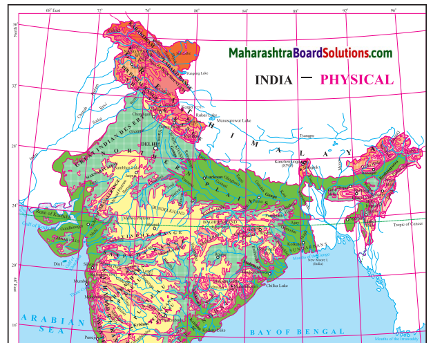
Maharashtra Board Class 10 Geography Solutions Chapter 3 Physiography and Drainage 1
Maharashtra Board Class 10 Geography Solutions Chapter 3 Physiography and Drainage 2

Physiography And Drainage Map Questions And Answers Question 1.
In which direction does the region with an altitude of more than 6000m lie in India ?
Answer:
The region with an altitude of more than 6000m lies part of India towards the north and north eastern.

Physiography And Drainage Questions And Answers  Question 2.
Look for the south-flowing river in the peninsular region. In which river basin does it lie?
Answer:
River Wardha and Vainganga are the south flowing river in the peninsular region. These lie in the Godavari river basin.

Physiography And Drainage Question 3.
In which direction is the slope of the region in the north shown in dark green.
Answer:
The region in the north shown in dark green is the North Indian Plain. It slopes towards the east.

Geography Class 10 Chapter 3 Physiography And Drainage Question 4.
Make a list of plateaus located in between Aravalli ranges and Chhota Nagpur Plateau.
Answer:
Plateaus located in between Aravalli ranges and Chhota Nagpur Plateau are Mewad Plateau, Bundelkhand, Baghelkhand and Malwa Plateau.

Physiography And Drainage Of India And Brazil Notes  Question 5.
Name the peak shown in the Eastern Ghats.
Answer:
Mahendragiri (1600m) and Malayagiri (1187m) are the peak shown in the Eastern Ghats.

Physiography And Drainage 10th Question 6.
Which mountains demarcate the deep plains of Brahmaputra?
Answer:
Dafla Hills, Naga Hills, Garo, Khasi and Jaintia Hills demarcate the deep plains of Brahmaputra.

Physiography And Drainage Class 10  Question 7.
Give the relative location of the Nilgiri Hills.
Answer:
Nilgiri Hills lie at the convergence of Western Ghats and Eastern Ghats in the southern part of the Deccan Pleateau.

10th Physiography Chapter 3 In Marathi Question Answer  Question 8.
In which direction does the height of Sahyadri hills increase?
Answer:
The height of Sahayadri hills increase towards the south.

Question 9.
The Vindhyas act as a water divide between which two river basins?
Answer:
The Vindhyas acts as a water divide between Ganga river system and Narmada river system.

Maharashtra Board Class 10 Geography Solutions Chapter 3 Physiography and Drainage

Observe the map and answer the following questions.
Maharashtra Board Class 10 Geography Solutions Chapter 3 Physiography and Drainage 3
Maharashtra Board Class 10 Geography Solutions Chapter 3 Physiography and Drainage 4

Question 1.
What is the range of altitude of the Amazon river basin?
Answer:
The range of altitude of the Amazon river basin is from 0 metres to 200 metres.

Question 2.
Between which two highlands is the Amazon river basin located?
Answer:
The Amazon river basin is located between the Guyana Highlands and the Brazilian Highlands.

Question 3.
Observe the region with the altitude of 500 to 1000 metres. Describe the locational extent of this region in yellow with reference to the direction.
Answer:
The region in yellow represents the Brazilian Highlands. They cover most of the eastern and southern parts of Brazil.

Question 4.
What do the isolated regions shown in yellow indicate?
Answer:
The isolated region shown in yellow indicate the Brazilian Highlands or the Brazilian Plateau or the Brazilian Shield.

Question 5.
Besides the Amazon river basin, where else do you find regions with an altitude of less than 200m?
Answer:
Besides the Amazon basin the other regions with an altitude of less than 200m are the Pampas, Parana and Paraguay basin, as well as the Eastern and Northen coastal region.

Question 6.
Describe the plateau region with height of 200 to 500m through which tributaries of Amazon flow in your own words.
Answer:
The highlands here gradually slope towards north and slopes are not very steep. The tributaries of Amazon, eg. Xingu river flowing through this region make rapids and waterfalls.

Question 10.
Enumerate the characteristics of the Western Ghats.
Answer:
(i) The Western Ghats are a continuous chain of mountains extending from north to south for about 1600 km. They run parallel to the west cost of India.
(ii) In the north, i.e., in Maharashtra and Karnataka these mountain ranges are referred as Sahyadris and in the south they are referred as Annamalai hills.
(iii) The height of the Western Ghats increases towards the south.
(iv) These hill ranges comprise of many peaks such as Kalsubai Peak (1646 m) located to the north and Anaimudi Peak (2695 m) located to the south of Western Ghats.
(v) The highest peak of Western Ghats is Anaimudi Peak (2695 m) located in Annamalai hills.
(vi) The western slope of the Western Ghats is steep while the eastern slope is gentle
(vii) The Western Ghats acts as a water divide for the rivers flowing towards Arabian Sea and Bay of Bengal.

Question 11.
Compare the Eastern Ghats and Western Ghats
Answer:

S.no Eastern Ghats Western Ghats
(i) The Eastern Ghats run along the eastern coast of India in the north east to south west direction. (i) The Western Ghats also known as Sahyadris run in the north-south direction along the western coast of India.
(ii) It forms the eastern boundary of the Deccan Plateau.                                          . (ii) It forms the western boundary of Deccan Plateau.
(hi) It is not continuous, but is broken at many places by rivers like Godavari and Krishna. (iii) The Western Ghats is like a continuous wall like structure, but is broken at same places by passes.
(iv) Comparatively less number of rivers originate from the Eastern Ghats. (iv) It is a source of many westward and eastward flowing rivers.
(v) The average altitude of the Eastern Ghats is low (600 mts) but they are wider than Western Ghats. (v) The average altitude of the Western Ghats is high (900-1600 mts) but it is narrower in width than Eastern Ghats.
(vi) Highest peak of Eastern Ghats is Jindhagada (1690 m) (vi) Highest peak of Western Ghats is Anaimudi Peak (2695 m)

Question 12.
Why are the Western Ghats called a water divide ?
Answer:
The Western Ghats divide the basins of the west flowing rivers like Vaitama, Mandovi, etc. flowing towards the Arabian sea from those of the east flowing rivers like Godavari, Krishna, etc. flowing towards the Bay of Bengal.

Maharashtra Board Class 10 Geography Solutions Chapter 3 Physiography and Drainage

Answer the following Questions:

Question 1.
Differentiate between the Physiography of Brazil and India.
Answer:

The Physiography of India The Physiography of Brazil
(i) The physiographic divisions of India are the Himalayas, the North Indian Plains and the Peninsula, Coastal Plains, and the Islands. (i) The physiographic divisions of Brazil are: The Highlands, The Great Escarpment, The Coastal region, The Plains and The Islands.
(ii) There are long and high mountain ranges in northern and north eastern part of India in the form of Himalayan ranges. The Western Ghats and the Eastern Ghats lie to the west and east of the Peninsular region. The average altitude of the Greater Himalayas is around 6000m. (ii) In Brazil there are no high and continuous mountain ranges. The eastern side of the Highlands is demarcated because of the Escarpment. The Great Escarpment located in south-eastern part of the Highlands has an altitude of 790m in this region with the height gradually decreasing.
(iii) In India the Plains occupy a wide area in the north. The Plains lie between the Himalayas in the North and the Peninsula in the South. It extends from Rajasthan in the West to Assam in the East. The Coastal Plains lie to the west and east of the Peninsula. (iii) In Brazil the Amazon Basin in the North and the Parana-Paraguay Basin to the South West constitutes the Plains. Also a narrow coastal plain is confined to the North and the East.
(iv) The Peninsular Plateau region of India lies to the South of the North Indian Plains and is divided into 2 groups, the The Central Highlands and the Deccan Plateau. (iv) In Brazil the Highlands occupy an extensive area in the South and is described as the Brazilian Highlands or the Brazilian Shield. Also to the North lies the Guyana Highland.
(v) The islands in India are either volcanic or coral in origin. (v) The islands in Brazil are mainly depositional and some of them are coral in nature.

Question 2.
What measures are being taken to control pollution in the rivers of India?
Answer:
Rivers in India are getting polluted due to the sewage and effluents being added to it and thus affecting its quality. Following measures are being taken to control pollution in the rivers in India.

  • Treating of the sewage before draining it into the rivers.
  • Reducing the use of pesticides and insecticides as they drain into the water sources and pollute it.
  • Discharge of industrial effluents into rivers without proper treatment is now controlled.
  • Reusing the water for different purposes which reduces the overuse and pollution of water.
  • Carrying out the cleaning and purification of the river water under the National River Conservation Plan (NRCP).
  • Creating awareness in the people about the importance of rivers and harmful effects of pollution.
  • Setting up of Pollution Control Boards (PCB) at the state and national level to curb pollution.

Question 3.
Explain the characteristics of the North Indian Plains.
Answer:
(i) This division lies between Himalayan Mountains in the north and the Peninsula in the south.

(ii) Similarly, it extends from Rajasthan and Punjab in the west to Assam in the east.

(iii) It is mostly a flat low lying area.

(iv) The North Indian Plains are divided into two parts. The part lying to the east of the Aravalis is the basin of the river Ganga and is therefore known as the Ganga Plains. It slopes eastward.

(v) Most of the Indian state of West Bengal and Bangladesh together constitute the delta of Ganga-Brahmaputra system. It is known as the Sunderbans. It is considered to be the world’s largest delta.

(vi) The western part of the North Indian Plains is occupied by desert known as the Thar Desert or Marusthali. Most of Rajasthan is occupied by this desert.

(vii) To the north of the desert lie the plains of Punjab.

(viii) This region is spread to the west of Aravalis and Delhi ranges. These plains have formed as a result of the depositonal work by river Satluj and its tributaries. The slope of the plains is towards the west.

(ix) Because the soil here is very fertile, agriculture is largely practised in this region.

Question 4.

What could be the reasons behind the formation of swamps in the extensive continental location of Pantanal?
Answer:
Pantanal is one of the largest wetlands in the world, lying in the south west part of the highland areas.

It is a region of swamps and marshes in northwestern part of Mato Grosso do Sul in Brazil and it extends into Argentina too.
This region is drained by the river Paraguay and its tributaries.

They collect the water from the highland areas and deposit the sediments in the low lying Pantanal region.

Pantanal is a gently sloped basin which is submerged throughout the year due to the filling of the sediments and water in the depression area of the Pantanal.

Question 5.

Which are the major water divides of India give examples.
Answer:
A mountain or an upland which separates two drainage basins is known as a Water Divide. The major Water Divides of India are :

Western Ghats: The Western Ghats acts as a water divide and separates the west flowing rivers like Zuari, Mandvi, Vaitama draining into the Arabian Sea, from the east flowing rivers like the Godavari, Krishna and Kaveri draining into the Bay of Bengal.

Vindhya ranges: It divides the drainage basin of the River Ganga and the River Narmada.

Aravali ranges: The Aravali ranges separate the west flowing river Luni from the east flowing river Banas.

Satpuda ranges: The Satpudas separate the Narmada drainage basin and the Tapi drainage basin.

Maharashtra Board Class 10 Geography Solutions Chapter 3 Physiography and Drainage

( Colours of Both )
Use the physical maps of India, Brazil and the indices to answer the following:

Question 1.
In which parts do the areas with highest altitude lie in both the countries, respectively?
Answer:
In India, the Himalayas occupying the northern and the north eastern part name highest altitude. In Brazil, the Escarpment occupying the southern part has highest altitude and the highest peak Pico de Neblina lies to the north in the Guyana Highlands.

Question 2.
In which country is the range of altitude higher?
Answer:
India has higher range of altitude as compared to Brazil.

Question 3.
Compare the highest range of altitudes given in both the countries. What difference do you see?
Answer:
The highest range of altitude in Brazil is more than 1000m, whereas in India, the highest range of altitude is more than 8000 m.

Question 4.
In which direction is the slope of the Amazon river basin region?
Answer:
The slope of Amazon Basin is towards the east.

Question 5.
In which direction is the slope of the Deccan Plateau of India ?
Answer: The slope of Deccan Plateau is towards the east.

Question 6.
Tell the regions of rain shadow in both the countries.
Answer:
The rain shadow regions of India are eastern side of Western Ghats on the Deccan Plateau and western side of Eastern Ghats. The rain shadow region of Brazil lies in the north eastern part of the Great Escarpment.

Question 7.
Write a comparative note on the basins of Ganga and Amazon river. You may consider following points for the comparison.
Answer:

Points for comparison Ganga River Basin Amazon River Basin
(1) Size of catchment area Spreading across the northern and eastern parts of India the Ganga River basin has a total catchment area of 10,16,124 sq. km. Spreading across the northern parts of Brazil the Amazon River basin has a total catchment area of 70,50,000 sq. km.
(2) Their relative location within respective countries The Ganga river basin lies to the south of the Himalayas in the North Indian plains and also occupies the northern part of the peninsula, i.e. the Central Highlands. The Amazon river basin occupies the entire region in the north of Brazil right from the Guyana Highlands to the northern part of the Brazilian Highlands.
(3) Headwater regions of rivers. Ganga river originates from the Gangotri Glacier in Uttarakhand. The Amazon river originates from the eastern slopes of Andes Mountains in Peru.
(4) Orientation of the rivers The Ganga flows eastwards passing through the states of Uttar Pradesh, Bihar and West Bengal and terminates into the Bay of Bengal. One of its branch enters into Bangladesh. The Amazon river flows from the west to the east entirely through the states of Amazonas and Para in northern Brazil and terminates into the North Atlantic Ocean.
(5) Major tributaries and their orientation (i)    Yamuna is the major right bank tributary of the river Ganga originating from the Yamunotri Glacier and meeting river Ganga at Allahabad. Other right bank tributaries originating from the Peninsula like river Chambal, Ken, Shon, Damodar, etc. flow northwards and join river Ganga.

(ii)  The left bank tributaries like river Gomati, Ghagra, Gandak, and Kosi flow south and meet river Ganga.

(i)    Rivers like Negro, Branka, Paru flow south from the Guyana Highlands and meet the Amazon river as left bank tributaries.

(ii)  River Madeira, Juruaka, Xingu and Tocantins flow northwards and join the Amazon river at its right bank.

(6) Any other point(s) (i)    The Ganga river basin is densely populated due to the deposition of fertile alluvial soil and plenty of water available for agriculture.

(ii)  Fertile plains and deltas are formed.

(iii)River Ganga is 2525 km long.

(iv)Water discharge is 16,648 cu.m, per sec.

(i)    Amazon river basin is sparsely populated due to dense equatorial rain forests, unfavourable climate and lack of transport links.

(ii)  No deltas are formed but islands have developed along the mouth of the Amazon River.

(iii) River Amazon is 6400 km long.

(iv)   Water discharge is 2,09,000 cu.m, per sec.

Question 8.
Distinguish between:
Eastern Ghats and Western Ghats.
Answer:

S.no Eastern Ghats Western Ghats
(i) The Eastern Ghats run along the eastern coast of India in the north east to south west direction. (i) The Western Ghats also known as Sahyadris run in the north-south direction along the western coast of India.
(ii) It forms the eastern boundary of the Deccan Plateau.                                          . (ii) It forms the western boundary of Deccan Plateau.
(hi) It is not continuous, but is broken at many places by rivers like Godavari and Krishna. (iii) The Western Ghats is like a continuous wall like structure, but is broken at same places by passes.
(iv) Comparatively less number of rivers originate from the Eastern Ghats. (iv) It is a source of many westward and eastward flowing rivers.
(v) The average altitude of the Eastern Ghats is low (600 mts) but they are wider than Western Ghats. (v) The average altitude of the Western Ghats is high (900-1600 mts) but it is narrower in width than Eastern Ghats.
(vi) Highest peak of Eastern Ghats is Jindhagada (1690 m) (vi) Highest peak of Western Ghats is Anaimudi Peak (2695 m)

Maharashtra Board Class 10 Geography Solutions Chapter 3 Physiography and Drainage

Class 10 Geography Chapter 3 Physiography and Drainage Additional Important Questions and Answers

Choose the correct option and rewrite the statements:

Question 1.
The part of North Indian Plains lying to the east of the Aravalis is called ____.
(a) Ganga Plains
(b) Brahmaputra Plains
(c) Kaveri Plains
(d) Krishna Plains
Answer:
(a) Ganga Plains

Question 2.
The delta of Ganga-Brahmaputra system is called ________.
(a) Sunderbans
(b) Parnaiba
(c) Amazon
(d) Marajo
Answer:
(a) Sunderbans

Question 3.
The western part of the North Indian Plains occupied by deserts known as ________.
(a) Thar Desert or Marusthali
(b) Gobi Desert
(c) The Deccan Thorn scrub Desert
(d) Spiti Valley Cold Desert
Answer:
(a) Thar Desert or Marusthali

Question 4.
The area lying to the south of North Indian Plains and tapering towards Indian Ocean is called _____.
(a) Himalayas
(b) Peninsula
(c) Western Ghats
(d) Indira Point
Answer:
(b) Peninsula

Question 4.
The in the north west of Peninsular India are the oldest fold mountains.
(a) Aravalis
(b) Satpudas
(c) Karakoram range
(d) Vindhya range
Answer:
(a) Aravalis

Question 6.
The ______ rivers in India are seasonal in nature.
(a) Northern
(b) Peninsular
(c) Himalayan
(d) Mountainous
Answer:
(b) Peninsular

Question 6.
River _______ is the second largest river system in India in terms of catchment area.
(a) Krishna
(b) Godavari
(c) Brahmaputra
(d) Ganga
Answer:
(b) Godavari

Question 7
The major river of Peninsula flows through the states of Karnataka and Tamil Nadu,
(a) Kaveri
(b) Indus
(c) Ganga
(d) Brahmaputra
Answer:
(a) Kaveri

Question 8.
India is blessed with a long coastline extending for approximately
(a) 8000 km
(b) 5000 km
(c) 7500 km
(d) 7900 km
Answer:
(c) 7500 km

Question 9.
The islands in the Arabian sea are called _______ islands.
(a) Andaman and Nicobar
(b) Barren
(c) Marajo
(d) Lakshadweep
Answer:
(d) Lakshadweep

Question 10
_____ is the southernmost range of the Himalayas.
(a) Himadri
(b) Lesser Himalayas
(c) Siwaliks
(d) Kumaon Himalayas
Answer:
(c) Siwaliks

Question 12.
The Islands in the Bay of Bengal are called _______ islands.
(a) Andaman and Nicobar
(b) Maldives
(c) Corsela
(d) Lakshadweep
Answer:
(a) Andaman and Nicobar

Maharashtra Board Class 10 Geography Solutions Chapter 3 Physiography and Drainage

Question 13.
The highest peak of Brazil is called _______.
(a) Pico de Neblina
(b) Mount Everest
(c) Kanchenjunga
(d) Mount Roraima
Answer:
(a) Pico de Neblina

Question 14.
The acts as a barrier to the south-east trade winds giving rise to the rain shadow area in the north – eastern part of the highlands in Brazil.
(a) Coastal Plains
(b) Escarpment
(c) Plateaus
(d) Pantanal wetlands
Answer:
(b) Escarpment

Question 15.
Amazon collects its headwaters from the eastern
slopes of Andes mountains in
(a) Uruguay
(b) Peru
(c) Ecuador
(d) Columbia
Answer:
(b) Peru

Question 16.
The Island is the only active volcano of India.
(a) Majuli
(b) St. Mary’s
(c) Barren
(d) Lakshadweep
Answer:
(c) Barren

Question 17.
______ is a large coastal island located between the mouths of river Amazon and river Tocantins,
(a) Pantanal
(b) Plata
(c) Paraniba
(d) Marajo
Answer:
(d) Marajo

Question 18.
_______ is one of the largest wetlands in the world.
(a) Plata
(b) Marajo
(c) Pantanal
(d) Paraniba
Answer:
(c) Pantanal

Question 19.
The Paraguay and the Parana rivers form the catchment of River in Argentina.
(a) Paraniba
(b) Plata
(c) Pantanal
(d) Marajo
Answer:
(b) Plata

Question 20.
____ River enters the Atlantic Ocean near Salvador town.
(a) Marajo
(b) Puraguaco
(c) Plata
(d) Parana
Answer:
(b) Puraguaco

Question 21.
The river ______ flows through Pakistan and then meets the Arabian Sea.
(a) Ganga
(b) Chambal
(c) Indus
(d) Brahmaputra
Answer:
(c) Indus

Question 22.
Ganga receives as its tributary in its lower reaches in Bangladesh.
(a) Satluj
(b) Indus
(c) Brahmaputra
(d) Ravi
Answer:
(c) Brahmaputra

Identify the correct group:

Question 1.
Parallel ranges of Himalayas from south to north
(i) Siwaliks – Lesser Himalayas – Greater Himalayas
(ii) Trans Himalayas – Kumaun – Shiwaliks
(iii) Kashmir Himalayas – Kumaun Himalayas – Assam Himalayas
Answer:
Siwaliks – Lesser Himalayas – Greater Himalayas

Question 2.
Physiographic division of India from north to south
(i) The Himalayas – The North Indian Plains – The Peninsula
(ii) The Peninsula – The Great Escarpment – The North Indian Plains
(iii) Coastal Plains – Islands – Himalayas
Answer:
The Himalayas – The North Indian Plains – The Peninsula .

Question 3.
Physiographic divisions of Brazil
(i) The Himalayas – The North Indian Plain – The Peninsula
(ii) The Highlands – The Great Escarpment – The Plains
(iii) Islands – Peninsula – Coastal Plains
Answer:
The Highlands – The Great Escarpment – The Plains

Maharashtra Board Class 10 Geography Solutions Chapter 3 Physiography and Drainage

Question 4.
Three major River Basins of Brazil
(i) Ganga Basin – Brahmaputra Basin – Narmada Basin.
(ii) Paraguay Parana Basin – Amazon Basin – Sao Francisco
(iii) Godavari Basin – Krishna Basin – Kaveri Basin.
Answer:
Paraguay Parana Basin – Amazon Basin – Sao Francisco

Question 5. The order of subdivisions of North Indian Plains from west to east.
(i) Marusthali – Ganga Plains – Sunderbans
(ii) Pamir; Knot – Punjab Plains – Marusthali
(iii) Sunderbans – Vindhyas – Western Ghats
Answer:
Marusthali – Ganga Plains – Sunderbans

Match the column:

Question 1.

Column ‘A’ Column ‘B’
(1)     Western Himalayas

(2)     Central Himalayas

(3)     Eastern Himalayas

(a)      Siwaliks

(b)     Assam Himalayas

(c)      Kashmir Himalayas

(d)     Kumaun Himalayas

Answer:
1-c
2-d
3-b

Question 2.

Column ‘A’ Column ‘B’
(1) Himalayas (a)  the western and eastern part of the Peninsula.
(2)   North Indian Plains (b) consists of many plateaus and hill ranges
(3)   The Peninsula (c) one of the young fold mountains in the world.
(4) The Coastal Plains (d) lies between Himalayan mountains in the north and the Peninsula in the south.
(5) The Island group (e) are located more than 300 km away from the mainland in the Atlantic ocean.
(f) small and large islands along the coast of the mainland.

Answer:
1 – c
2 – d
3 – b
4 – a
5 -f

Question 3.

Column ‘A’ Column ‘B’
(1) The southernmost point of India (a) Gangotri
(2) The highlands in eastern Brazil (b) Andes mountains
(3) The origin of Ganga (c) Guyana Highlands
(4) The origin of Amazon (d) Indira Point
(5) The southern most point of mainland India (e) Kanyakumari
(f) The Great Escarpment

Answer:
1 – d
2 -f
3 – a
4 – b
5 – e

Question 4.

S.no Column ‘A’ Column ‘B’
1.  Longest river of India (a) Sao Francisco
2.  Second largest river of India (b) Godavari
3  Longest river of Brazil (c)    Ganga

(d)    Brahmaputra

(e)    Amazon

Answer:
1 – c
2 – b
3 – e

Answer the following in one sentence:

Question 1.
Which mountain is considered as one of the young fold mountains in the world?
Answer:
The Himalayas are considered as one of the young fold mountains in the world.

Question 2.
What is the southernmost range of Himalayas called?
Answer:
The southernmost range of Himalayas is called the Siwaliks.

Maharashtra Board Class 10 Geography Solutions Chapter 3 Physiography and Drainage

Question 3.
Where are the North Indian Plains located?
Answer:
The North Indian Plains lies between Himalayan Mountains in the north and the Peninsula in the south.

Question 4.
Where are the Ganga Plains located?
Answer:
The Ganga Plains lie to the east of the Aravalli in the North Indian Plain.

Question 5.
What constitutes the delta of Ganga-Brahmaputra system?
Answer:
Most of the West Bengal state of India and Bangladesh together constitute the delta of Ganga Brahmaputra system.

Question 6.
What are Sunderbans?
Answer:
The delta region of Ganga-Brahmaputra system are called the Sunderbans and it extends from Indian state of West Bengal to Bangladesh.

Question 7.
What is the length of the coastline of India?
Answer:
The length of the coastline of India is approximately 7500 km.

Question 8.
Why do the rivers originating from Western Ghats form estuaries?
Answer:
Rivers originating from Western Ghats are short and swift, hence they form estuaries.

Question 9.
What are the islands located in the Arabian Sea called?
Answer:
The Islands located in the Arabian sea are called Lakshadweep Islands.

Question 10.
What are the islands located in the Bay of Bengal called?
Answer:
The islands located in the Bay of Bengal are called Andaman and Nicobar Islands.

Question 11.
Name the only active volcano in India.
Answer:
Barren Island is the only active volcano in India located in Andaman and Nicobar Islands.

Question 12.
Which is the highest peak in Brazil?
Answer:
The highest peak in Brazil is Pico de Neblina.

Question 13.
What acts as a barrier to the South East trade winds giving rise to rainshadow area in the northeastern part of the highlands in Brazil?
Answer:
The Escarpment acts a barrier to the South East Trade winds giving rise to rainshadow area in the northeastern part of the highlands in Brazil.

Question 14.
Name the coastal island located between the mouths of river Amazon and river Tocantins.
Answer:
Marajo is a large coastal island located between the mouths of River Amazon and River Tocantins.

Question 15.
What are most of the Amazon Plains covered with?
Answer:
Most of the Amazon Plains are covered with tropical rainforests.

Question 16.
Where is Pantanal located?
Answer:
Pantanal is located in the northwestern part of Mato Grosso Do Sul in Brazil and it extends into Argentina.

Question 17.
What is a ‘Drought Quadrilateral’?
Answer:
The rain shadow region of Trade Winds lying in the northern part of Brazil is called ’Drought Quadrilateral’.

Question 18.
What is the Brazilian coast characterized by?
Answer:
The Brazilian coast is characterised by a large number of beaches and sand dune complexes.

Question 19.
What protects the Brazilian coast?
Answer:
The Brazilian coast is protected in some areas by coral reefs and atoll islands.

Question 20.
What is Pantanal?
Answer:
Pantanal, which is a region of swamps and marshes is one of the largest wetlands in the world. Located in the northwestern part of Mato Grosso Do Sul in Brazil.

Question 21.
From where does Amazon collect its head waters?
Answer:
Amazon collects its headwaters from the eastern slopes of the Andes Mountains in Peru.

Question 22.
Where does the river Sao Francisco flow?
Answer:
The river flows towards the north for a distance of about 1000 km. over the Brazilian plateau and takes a sharp eastward turn to enter the coastal : strip along the Atlantic Ocean.

Question 23.
Which rivers meet the North Atlantic Ocean?
Answer:
River Paraniba and River Itapecuru meet the North Atlantic Ocean.

Question 24.
Which two river systems are covered under the Himalayan Drainage System?
Answer:
The Himalayan Drainage System cover two major river systems such as the Indus river system and the Ganga river system.

Question 25.
What are ’Kayals’?
Answer:
The coastal rivers in Kerala have long extending backwaters near their mouths, which are locally known as ’Kayals.’

Question 26.
Name the three major river basins of Brazil.
Answer:
The three major river basins of Brazil are Amazon Basin, Paraguay-Parana system in the southwest and Sao Francisco in the eastern part of the highland.

Question 27.
What is the approximate discharge of Amazon river?
Answer:
The approximate discharge of Amazon river is about 2 lakh m3/s.

Question 28.
Where are the rivers Paraguay-Parana located?
Answer:
The rivers Paraguay and Parana are located in the south-western part of Brazil.

Question 29.
Which is the third important river of Brazil?
Answer:
Sao Francisco is the third important river of Brazil.

Maharashtra Board Class 10 Geography Solutions Chapter 3 Physiography and Drainage

Question 30.
How are Indian rivers classified?
Answer:
The rivers in India are classified into Himalayan and Peninsular rivers.

Question 31.
Name the major tributary of river Ganga.
Answer:
Yamuna, originating at Yamunotri is a major tributary of Ganga.

Question 32.
From where do Himalayas extend?
Answer:
The Himalayas extend from Pamir Knot in Tajikistan to the east.

Question 33.
Which physical division lies between the Himalayas and the Peninsula?
Answer:
The North Indian Plains lie between the Himalayas in the north and the Peninsula in the south.

Question 34.
Which physical division forms the core of the South American continent?
Answer:
The Brazilian and Guyana Highlands forms the core of the South American continent.

Question 35.
The Guyana highlands cover, which states of Brazil?
Answer: The Guyana highlands cover the states of Roraima, Para and Amapa in Brazil.

Question 36.
Because of which physical division is the eastern side of Brazilian highlands are demarcated?
Answer:
The eastern side of Brazilian highlands are demarcated because of the Great Escarpment.

Question 37.
Which is the largest plain land of Brazil?
Answer:
The Amazon plains lying in the northern part is the largest plain land of Brazil.

Question 38.
On which coast of India are deltas found?
Answer:
Deltas are found on the eastern coast of India.

Name the following:

Question 1.
Five major physiographic divisions of India.
Answer:
The Himalayas, The North Indian Plains, The Peninsula, Coastal Plains and Island groups.

Question 2.
West-East division of Himalayas.
Answer:
Western Himalayas (Kashmir Himalayas),
Central Himalayas (Kumaun Himalayas) and Eastern Himalayas (Assam Himalayas).

Question 3.
Region constituting delta of Ganga-Brahmaputra system or world’s largest delta. .
Answer:
Sunderbans.

Question 4.
Coast bordering Arabian sea.
Answer:
Western Coast.

Question 5.
Coast bordering Bay of Bengal.
Answer:
Eastern Coast.

Question 6.
Islands in the Arabian Sea.
Answer:
Lakshadweep Islands.

Question 7.
Islands in the Bay of Bengal.
Answer:
Andaman and Nicobar Islands.

Maharashtra Board Class 10 Geography Solutions Chapter 3 Physiography and Drainage

Question 8.
Other name of Thar Desert.
Answer:
Marusthali.

Question 9.
Ranges in the central part of India.
Answer:
Vindhyas and Satpuda.

Question 10.
Physiographic divisions of Brazil.
Answer:
The Highlands, The Great Escarpment, The Coasts, The Plains, The Island group.

Question 11.
Length of coastline of Brazil.
Answer:
Approximately 7400 km

Question 12.
Major river basins of Brazil.
Answer:
Amazon Basin, Paraguya-Parana system, Sao Francisco.

Question 13.
Two main Himalayan river basins of India.
Answer:
Ganga river basin and Indus river basin.

Question 14.
Origin of Ganga in Himalayas
Answer:
Gangotri Glacier

Question 15.
Major tributary of Ganga
Answer:
Yamuna river.

Question 16.
Tributaries of River Indus.
Answer:
Rivers Jhelum, Chenab, Ravi, Beas, and Satluj.

Question 17.
Origin of River Satluj.
Answer:
Mansarovar.

Question 18.
Rivers flowing into the Gulf of Khambhat.
Answer:
Rivers Tapi, Narmada, Mahi, and Sabarmati.

Question 19.
River basin located to the south of River Godavari.
Answer:
Basin of River Krishna.

Question 20.
Plains formed due to depositional work of river Satluj.
Answer:
Punjab Plains.

Question 21.
Tributaries of Peninsula joining the Ganga basin.
Answer:
Rivers Chambal, Ken, Betawa, Shon, and Damodar.

Question 22.
States having short and swift river systems.
Answer:
Kerala, Karnataka, Goa and Maharashtra.

Question 23.
River originating from the eastern slopes of Western Ghats.
Answer:
Rivers Godavari, Krishna and Kaveri.

Question 24.
Largest wetlands in the world.
Answer:
Pantanal.

Question 25.
Highest peak of Brazil
Answer:
Pico de Neblina.

Question 26.
Western border of Indian Peninsula.
Answer:
Western Ghats.

Question 27.
Eastern border of Indian Peninsula.
Answer:
Eastern Ghats.

Question 28.
Oldest fold mountains of India.
Answer:
Aravallis.

Question 29.
Major mountain system of Asia.
Answer:
Himalayas.

Maharashtra Board Class 10 Geography Solutions Chapter 3 Physiography and Drainage

Identify the type on the basis of the statement

Question 1.
A landform formed due to deposition of sediment carried by a river as the flow leaves its mouth and enters slower-moving or standing water.
Answer:
Delta.

Question 2.
The area where land meets the sea or ocean, or a line that forms the boundary between the land and the ocean or a lake.
Answer:
Coast.

Question 3.
Portion of land drained by a river and its tributaries.
Answer:
River Basin.

Question 4.
majority of its border, (Usually three sides) while being connected to a mainland from which it extends.
Answer:
The Peninsula.

Question 5.
A steep slope or long cliff that forms as an effect of faulting or erosion and separates two relatively leveled areas having differing elevations.
Answer:
Escarpment.

Question 6.
Any piece of land that is surrounded by water all the sides.
Answer:
Island.

 Mark the following on the map with the given information:

Question 1.
On the outline map of India.
(a) Aravali hills
(b) Himalayas/Greater Himalayas
(c) Vindhya Range and Satpuda Range
(d) Gulf of Mannar
(e) Western Ghats
(f) Eastern Ghats
(g) Gulf of Kutch
(h) Gulf of Khambhat
(i) K2
(j) Sunderbans
(k) Thar Desert/Marusthali
Answer:
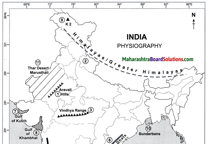
Maharashtra Board Class 10 Geography Solutions Chapter 3 Physiography and Drainage 5
Maharashtra Board Class 10 Geography Solutions Chapter 3 Physiography and Drainage 6

Question 2.
On the outline map of India mark the following.
(a) Northern Mountainous Region
(b) North Indian Plains
(c) The Peninsular Plateau
(d) Western Coastal Plain
(e) Eastern Coastal Plain
(f) Lakshadweep Island
(g) Andman-Nicobar Islands
(h) Western and Eastern Ghats
Answer:
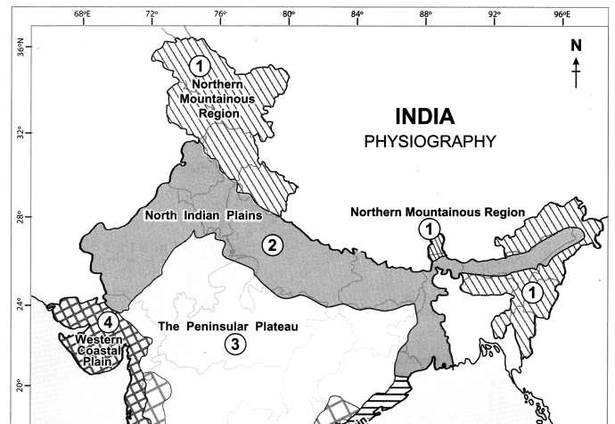
Maharashtra Board Class 10 Geography Solutions Chapter 3 Physiography and Drainage 15
Maharashtra Board Class 10 Geography Solutions Chapter 3 Physiography and Drainage 8

Maharashtra Board Class 10 Geography Solutions Chapter 3 Physiography and Drainage

Question 3.
Show the following on the outline map of India.
(a) R. Ganga
(b) R. Indus
(c) R. Brahmaputra
(d) R. Narmada
(e) R. Tapi
(f) R. Godavari
(g) R. Mahanadi
(h) R. Krishna
(i) R. Kaveri
(j) R. Luni
(k) R. Sabarmati
(l) R. Mahi
(m) R. Yamuna
(n) R. Damodar
Answer:
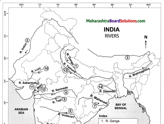
Maharashtra Board Class 10 Geography Solutions Chapter 3 Physiography and Drainage 16
Maharashtra Board Class 10 Geography Solutions Chapter 3 Physiography and Drainage 10

Question 4.
On the outline map of Brazil, mark the following:
(a) Guyana Highlands
(b) Brazilian Highlands
(c) Great Escarpment
(d) Marajo Island
(e) Marajo Bay
(f) Sao Marcos Bay
(g) Atlantic Ocean
(h) Pantanal Wetlands
(i) Pico De Neblina Peak
(j) Cassino Beach
Answer:
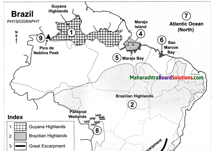
Maharashtra Board Class 10 Geography Solutions Chapter 3 Physiography and Drainage 17
Maharashtra Board Class 10 Geography Solutions Chapter 3 Physiography and Drainage 12

Question 5.
On an outline map of Brazil, show all major rivers of Brazil.
(a) River Amazon
(b) River Sao Francisco
(c) River Parana
(d) River Paraguay
(e) River Itapecuru
(f) River Paraniba
(g) River Puraguaco
(h) River Uruguay
Answer:
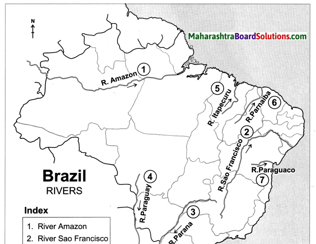
Maharashtra Board Class 10 Geography Solutions Chapter 3 Physiography and Drainage 181
Maharashtra Board Class 10 Geography Solutions Chapter 3 Physiography and Drainage 14

Answer the following questions:

Question 1.
There are no deltas on the western coast of India.
Answer:
(i) Deltas are formed in the coastal areas where there is gentle slope, because the rivers slow down forming distributaries and channels.

(ii) The western coast bordering the Western Ghats are by and large rocky coasts having a narrow width.

(iii) Many short and swift seasonal rivers originate from the steep western slopes of the Western Ghats.

(iv) As the rivers flow through steep slopes, their velocity increases. So there is very little deposition
made by them.

(v) Hence, there are no deltas on the western coast of India.

Maharashtra Board Class 10 Geography Solutions Chapter 3 Physiography and Drainage

Question 2.
Many deltas are found along the Eastern coast of India.
Answer:
(i) The eastern coast borders the Bay of Bengal. It has been formed as a result of depositional work of rivers.

(ii) Many east flowing rivers rising from the Western and Eastern Ghats after travelling a long distance join the Bay of Bengal at this coast.

(iii) Because of the gentle slope of the land, rivers flow at lower velocities and deposit the sediments brought with them at the coast.
Therefore, this coast is comparatively wider than the west.

(iv) As a result, deltas are found along the eastern coast of India.

Question 3.
The region to the north of the Escarpment is called Drought Quadrilateral.
Answer:
(i) The eastern side of the Highlands is demarcated because of the Escarpment having an altitude of 790 m.

(ii) The Escarpment acts as a barrier to the Southeast trade winds and cause orographic type of rainfall in the coastal region.

(iii) Beyond the highlands the effect of these winds gets reduced leading to minimal rainfall.

(iv) A rain shadow region is formed to the north east of the Escarpment. Thus, the region to the north of this area is called “Drought Quadrilateral”.

Question 4.
The Amazon Plains are covered by inaccessible tropical rainforest.
Answer:
(i) The northern part of Brazil lying between the Equator and the Tropic of Capricorn, i.e. in the Tropical zone is covered largely by the Amazon Plains.

(ii) Amazon plains lying between the Guyana highlands and the Brazilian highlands form the largest plain land of Brazil.

(iii) The Amazon valley receives very heavy rainfall of around 2000 mm and the average temperature here is 25 to 28°C.

(iv) These conditions favor the dense growth of tropical rain forests. Due to frequent flooding and dense undergrowth, these forests are largely inaccessible.

Question 5.
Pantanal is called the largest wetlands in the world.
Answer:
(i) Pantanal lies towards the south western part of the highland area in Brazil.

(ii) Roughly 80% of the Pantanal flood plains are submerged during the rainy season.

(iii) This region is filled with swamps and marshes from the northwestern part of Mato Grosso Do Sul in Brazil till Argentina.

(iv) Hence Pantanal is called the largest wetland in the world.

Question 6.
Agriculture is widely practised in the plains of Punjab region.
Answer:
(i) Plains of Punjab lie to the north of Rajasthan. This region is spreads to the west of Aravalis and Delhi ranges.

Question 1. These plains have formed as a result of the depositional work by river Sutluj and its tributaries.

(iii) Since the soil here is very fertile, agriculture is largely practised in this region.

(iv) Thus, due to.the availability of fertile soil and ample water suppy agriculture is practised here.

Question 7.
Write notes on :
Answer:

The Western Ghats:

(i) Western Ghats also known as Sahyadri (Benevolent Mountains) is a mountain range that runs parallel to the western coast of the Indian peninsula.

(ii) The range runs north to south along the western : edge of the Deccan Plateau, and separates the plateau from a narrow coastal plain, called West coastal plan, along the Arabian Sea.

(iii) The range starts near the border of Gujarat and Maharashtra, south of the Tapi river, and runs approximately 1,600 km through the states of Maharashtra, Goa, Karnataka, Kerala and Tamil Nadu ending near Kanyakumari, at the southern tip of India.

(iv) The altitude of the western Ghats increases towards the south.

Island group of India:

(i) India has many small and large islands along the coast of the mainland. These are included in the coastal island group.

(ii) Besides, India has two large group of islands, one each in the Arabian Sea and in the Bay of Bengal.

(iii) The islands in the Arabian Sea are known as Lakshadweep whereas the islands in the Bay of Bengal are called the Andaman and Nicobar Islands.

(iv) Most of the islands in Lakshadweep are atoll islands.

(v) They are small in extent and not very high.

(vi) Islands in the Andaman group are mainly volcanic islands.

(vii) They are large with hills in their interior parts, which includes an island called Barren Island which has the only active volcano in India. There are atolls in the Nicobar group too.

 Brazilian Highlands:

(i) Southern Brazil is occupied by an extensive plateau. It is known as the Brazilian Highlands or the Brazilian Shield or the Brazilian Plateau.

(ii) Brazilian and Guyana Highlands together form the core of South American continent.

(iii) The main part of the Guyana Highlands is in Venezuela and it extends up to French Guiana. In Brazil, it covers the states of Roraima, Para and Amapa in the north.

(iv) The lower part of these highlands is found in Brazil. But the highest peak of Brazil, Pico de Neblina, 3014 m lies on the border between Brazil and Venezuela.

(v) The regions to the east and south of the Brazilian highlands have an altitude of more than 1000m. But in other parts, the altitude is between 500 to 1000m.

(vi) The highlands gradually slope towards north and the slopes are not very steep.

(vii) The tributaries of Amazon flowing through this region make rapids and waterfalls. Towards the north the slopes are steep but not abrupt. A number of rivers originate from the terminal portion of the highlands and flow northwards to meet Atlantic Ocean.

(viii) Some major rivers like Uruguay, Paraguay and Parana originate from the southern slopes of the highlands and enter Argentina. Its slope towards the east is steep and it appears in the form of an escarpment.

Maharashtra Board Class 10 Geography Solutions Chapter 3 Physiography and Drainage

Coastal Plains of India:

(i) India is blessed with a long coastline extending for approximately 7500 km.

(ii) It lies to the western and eastern part of the Peninsula. Its western and eastern coastlines show remarkable dissimilarities.

(iii) The western coast borders the Arabian Sea. It is by and large a rocky coast.

(iv) At places, spurs starting from the Western Ghats have extended right up to the western coast. Its width is also less.

(v) Rivers originating from Western Ghats are short and swift and hence they form estuaries and not deltas.

(vi) The eastern coast borders the Bay of Bengal. It has formed as a result of depositional work of rivers.

(vii) Many east flowing rivers rising from the Western and Eastern Ghats meet the eastern coast.

(viii) Because of the gentle slope of the land, rivers flow at lower velocities and deposit the sediments brought with them at the eastern coast. As a result, deltas are found along this coast.

The Plains of Brazil:

(i) The plains in Brazil are confined to two areas namely the Amazon basin in the north and Paraguay-Parana source region in the southwest.

(ii) Amazon plains lying between the two highlands form the largest plain land of Brazil.

(iii) Amazon plains lying in the northern parts of Brazil generally slope eastwards.

(iv) The Amazon basin is quite wide in the west (about 1300 km) and it narrows eastward. Its width is minimum where the Guyana Highlands and Brazilian Highland come closer. (240 km.)

(v) As the river approaches the Atlantic Ocean, the width of the plains increases.

(vi) These are mostly forested areas and largely inaccessible due to frequent flooding and dense undergrowth. Most of the Amazon plains are covered by tropical rainforests.

(vii) The other plains in Brazil are located to the southwestern part of the highlands. They form the source region of Paraguay and Parana rivers.

(viii) The source region of Paraguay slopes towards the south while the source region of Parana slopes towards the southwest.

(ix) Pantanal is one of the largest wetlands in the world. It lies towards the southwest part of the highland areas. It is a region of swamps and marshes in northwestern part of Mato Grosso Do Sul in Brazil and it extends into Argentina.

Coastal Rivers of Brazil:

(i) Brazil has a number of short coastal rivers.
Question 1. The coastal area being densely populated these rivers attain significance.
(iii) River Pamaiba and River Itapecuru flowing northwards meet the North Atlantic Ocean.
(iv) The rivers that enter South Atlantic Ocean collect their headwaters along the escarpment.
(v) River Puraguaco enters the Atlantic Ocean near Salvador town.

Paraguay – Parana system:

(i) These two rivers are located in the southwestern part of Brazil.
(ii) Both the rivers form the catchment of River Plata in Argentina.
(iii) These two rivers and river Uruguay in extreme south of the highlands collect their headwaters from the southern portion of the highlands.

Indus River System:

(i) Indus and its tributaries (Jhelum, Beas, Chenab, Ravi and Satluj) drain the Western Himalayas i.e., they flow through the state of Jammu and Kashmir.

(ii) They flow almost parallel to each other.

(iii) A major tributary of river Indus, the Satluj, originates near Mansarovar and flows westwards.

(iv) Punjab Plains have formed from the depositional work of this river and its tributaries.

(v) Indus flows through Pakistan and then meets the Arabian Sea.

Ganga River System:

(i) The river Ganga originates from the Gangotri glacier and crosses the Himalayas to become an east-flowing river.

(ii) Many tributaries of the Ganga also flow in a similar manner.

(iii) River Yamuna, originating at Yamunotri, is a major tributary of Ganga.

(iv) Another major tributary of the Ganga flows through the northern part of the Greater Himalayas, crosses the Himalayas to enter India.

(v) When it flows through the Himalayas it is called Tsang Po.

(vi) When it crosses the Himalayas, it is called Dihang and its eastward flow thereafter is called as Brahmaputra.

(vii) From time to time, Ganga meets its tributaries, hence its discharge increases.

(viii) Ganga receives Brahmaputra as its tributary in its lower reaches in Bangladesh. The huge volume of water and huge deposition has led to the formation of a large delta.

(ix) Besides these Himalayan rivers, Ganga receives a number of tributaries from Peninsula like Shon, Damodar, etc.

Rivers Meeting the Arabian Sea:

(i) The west flowing rivers occupying the area between the Western Ghats and the Arabian Sea are short in length but swift.

10th Std Geography Questions And Answers:

Field Visit Question Answer Class 10 Geography Chapter 1 Maharashtra Board

Balbharti Maharashtra State Board Class 10 Geography Solutions Chapter 1 Field Visit Notes, Textbook Exercise Important Questions and Answers.

Std 10 Geography Chapter 1 Question Answer Field Visit Maharashtra Board

Class 10 Geography Chapter 1 Field Visit Question Answer Maharashtra Board

Geography Class 10 Chapter 1 Question Answer Maharashtra Board

Answer in short :

Field Visit Geography Class 10 Questions And Answers Question 1.
Make a report on your field visit.
OR
On the basis of which points will you write the tour report?
Answer:
The following points should be used for preparing a report.

  • Introduction
  • Location and route map
  • Physiographic features
  • Climate
  • Plant and animal life
  • Human settlements
  • Occupations
  • Land use and type of crops
  • Important historical places
  • Environmental problems and measures
  • Conclusion
  • Use of diagrams, graphs, pictures can be taken to support the information collected during the field visit.

Maharashtra Board Class 10 Geography Solutions Chapter 1 Field Visit

Field Visit Geography Class 10 Question 2.
Prepare a questionnaire for a field visit to a factory.
Answer:
A questionnaire for a field visit to a factory will be as follows:

  • What is the name of the factory?
  • What is the location of the factory?
  • Which product is manufactured in the factory?
  • What are the raw materials used to make the final goods?
  • Where do the raw materials come from?
  • In which market is the final product sold?
  • How many people are employed in the factory?
  • Do you have shifts for your employees? What are their timings?
  • What safety measures do you adopt for your staff?
  • What precautions have been taken to prevent a fire hazard?
  • What precautions have been taken to prevent or reduce environmental pollution?
  • What mode of transport is used for the movement of raw materials and finished goods?

Question 3.
What items will you take with you for the field visit?
Answer:
We will take the following items with us for the field visit:

  • Notebook, pen, pencil, camera, binoculars, etc to collect information.
  • Magnetic compass, GPS enabled mobile phone and also maps to know directions and locate various places.
  • I-card, water bottle, cap, and a first aid box are a must.
  • Ziplock bag for collecting samples.
  • Carry a questionnaire and information booklet about the place to be visited.
  • Carry some bags to discard any trash.

Question 4.
Outline the importance of a field visit.
OR
Explain with examples of how field visits increase geographical knowledge.
Answer:
(i) Geography is a science to be learnt through observation.
(ii) Field study gives us an opportunity to get firsthand information of the new place having a different location, climate and landforms.
(iii) Students learn the relationship between physical and cultural factors and how man adapts himself accordingly.
(iv) They get an opportunity to interact with the local people, know about their culture, food, clothing and understand their problems.
(v) Students develop the feeling of belonging to these regions and their skill of observation and reasoning also improves.

Class 10 Geography Chapter 1 Field Visit InText Questions and Answers

Short Answers:

Question 1.
Correlate pulse cropping with low rainfall.
Answer:
(i) Extreme weather events during growing and harvesting seasons can cause serious damage to crops.
(ii) Pulses are very sensitive to torrential rain, especially in the early vegetative stage and flowering stage.
(iii) A high quantity of rainfall can cause disease infestation in crops.
Hence, pulses are grown in places where there is less to moderate rainfall.

Maharashtra Board Class 10 Geography Solutions Chapter 1 Field Visit

Question 2.
Do you agree that regions and necessities influence the difference in the means of livelihood?
Answer:
(i) A person’s livelihood refers to their “means of securing the basic necessities of – food, water, shelter and clothing – of life.”
(ii) To acquire above necessities, people work either individually or as a group by using skills (both human and material) for meeting the requirements of the self. The activities are usually carried out repeatedly.
(iii) For instance, a fisherman’s livelihood depends on the availability and accessibility of fish and depending on this, primary, secondary and tertiary occupations will develop, like making of boats, nets, fish canning, transportation, etc.
(iv) So, definitely the regions and necessities influence the difference in the means of livelihood.

Question 3.
Give geographical reasons:
It is important to manage the waste during field visit.
Answer:
(i) It is our social responsibility to ensure that the cleanliness and sanctity, of the place of visit is maintained during the visit.
(ii) Managing environment also shows how responsible we are.
(iii) Managing environment assists in the prevention of the environmental pollution.

Question 4.
If you were a part of a field visit, what preparations would you make?
OR
Suppose teachers ask you to plan the visit. How will you plan the details of the trip?
If you were a part of a field visit, what preparations would you make?
OR
Suppose teachers ask you to plan the visit. How will ,you plan the details of the trip?
Answer:
Following preparations / plans will be made for the field visit:
(i) Deciding the place : Deciding an appropriate place for the field visit, selecting the means of transportation, and duration of the field visit should be planned well ahead.
e.g. selecting a place like fort/ factory/ hill station, etc.

(ii) Deciding the purpose : Deciding the objectives of the field visit and the elements which will be observed in the field visit should be decided, e.g. visiting a village to understand the problems faced by rural people in their daily life and finding solutions.

(iii) Collecting important documents : Collecting important documents like the location map, permission letters, etc.
e.g. For a visit to a factory, permission letter of the factory owner is required.

(iv) Preparing for emergencies : Preparing for emergencies is very important.
e.g. carrying first – aid kit, GPS enabled mobile phone, dry snacks, water bottle, etc.

(v) Preparing the budget: With the help of a teacher make a budget and plan the travel, stay and food expenses.

(vi) Planning the journey : Study the location map and the route map of the place to be visited. Distance, transport route should be planned. Also plan the time of departure and the entire schedule of the visit.

(vii) Making a list of items required : Water bottle, dry snacks, book, pen, binoculars, compass, camera, etc.

Question 5.
What precautions will you take continuously during the field visit?
Answer:
(i) Strictly obey instructions given by teachers.
(ii) Ensure safety of oneself and others, carry first – aid box, identity cards, etc. for emergency.
(iii) Note down information gathered immediately in the book and preserve the book and samples collected carefully.
(iv) Take photographs of sites / people wherever necessary during the field visit.
(v) Safeguard the natural surroundings and the historical monuments during the visit.
(vi) Do not litter and cause any inconvenience or harm to anybody.

Question 6.
Collect more information about mud and wood houses. (Dhabyachi ghare)
Answer:
(i) Dhabyachi ghare or mud and wood houses are made of earth mixed with water and organic materials such as straw or dung. The roof is made up of wood.
(ii) Straw is useful in binding the brick together and allowing the brick to dry evenly, thereby preventing cracking due to uneven shrinkage through the brick. Dung offers the same advantage.
(iii) These houses are built in the low rainfall areas of Maharashtra e.g. Vidarbha, Marathwada.

Maharashtra Board Class 10 Geography Solutions Chapter 1 Field Visit

Question 7.
Obtain information regarding Multi-purpose Projects.
Answer:
(i) Projects which serve more than one purpose are called as Multipurpose Projects.
(ii) Multi purpose Projects are planned for various purposes like irrigation and hydropower generation, water supply for drinking and industrial purpose, flood control, navigation etc.
(iii) For e.g. Bhakra Nangal Multipurpose Project on River Sutlej, Jayakwadi Multipurpose Project on River Godavari, etc.

Question 8.
‘Vegetation is an indicator of difference in precipitation’. What are the other indicators of difference in precipitation?
Answer:
(i) Crops grown in a particular region can be one of the indicators of precipitation.

(ii) The type of houses found in the region is an indicator of precipitation. For e.g. in low rainfall regions, flat roof houses are found whereas in heavy rainfall regions houses have slanting roofs.

(iii) Texture and colour of the soil, humidity in the air, etc. are indicators of precipitation.

(iv) As temperatures rises, more people will need to keep cool by using air conditioner, which uses a lot of electricity. So, consumption of energy is another indicator of precipitation.

(v) Animal life can also be affected. If the climate is not suitable – (too wet, too dry, or too cold in winter) – plants and the animals that depend upon them for food or habitat will struggle or die.

Question 9.
How will the terrain below appear to the birds from the sky?
Answer:
(i) To the birds flying in the sky, the terrain will look like a flat land.
(ii) Every object on the terrain will look very small in size.

Question 10.
Out of which process has the plateau of Maharashtra formed? What is the main type of rock seen here?
Answer:
(i) The Deccan Plateau was formed due to volcanic eruptions.
(ii) The Deccan Plateau is made up of basalt rock.

Question 11.
Guess in which season of the year is the field visit being undertaken?
Answer:
The following points tell us that the field visit is being undertaken in the rainy season.
(i) Paddy fields are visible.
(ii) Waterfalls are seen in the Sahyadris.

Question 12.
What is the concept of ‘Devrai’?
Answer:

  • Devrai means sacred groves / patch of forest.
  • In Maharashtra small patches of forest in the Ghats are protected by local people.
  • It is based on the understanding that all creations of nature have to be protected. Such beliefs have preserved several virgin forests in pristine form.
  • These patches of forests or parts of large forests have been left untouched by the local people and any interference with them is banned.

Question 13.
What precautions have to be taken while going to the sea coast?
Answer:
The following precautions must be taken while going to the sea coast:

  • Sun exposure at the sea is quite high. So, bring sunglasses and a hat to beat the sun’s rays and prevent sunburn.
  • Consult the local people before entering the sea water.
  • Avoid going beaches if there’s lightning in the forecast.
  • Don’t go in deep water, if you do not know to swim.
  • Beware of the waves, some are more powerful than you think.
  • Don’t climb edges of rocks to click photographs, as they may be slippery.
  • Be sure to bring plenty of water.
  • Do not wear expensive watches and jewellery when going to the sea coast.

Maharashtra Board Class 10 Geography Solutions Chapter 1 Field Visit

Question 14.
What is the simplest method of understanding the timings of the tides?
Answer:

  • Tides are defined as the rise and fall of sea levels, caused by the combined effects of gravitational forces of the Moon, the Sun and the rotation of Earth.
  • The simplest method of understanding the timings of the tides is by asking the local people.
  • One can also do the same through observation, This tidal range typically changes twice daily.
  • Since the lunar high tides occur every 12 hours and 25 minutes, which means that it takes 6 hours and 12.5 minutes to go from high tide to low tide or vice versa.

Question 15.
What type of photographs will you click with respect to the field visit?
Answer:

  • The type of photographs to be clicked will depend on the purpose and place to visit.
  • If the purpose of field visit is to study landforms then we will click pictures of mountains slopes, plateaus and plains.
  • If the purpose of the visit is to study a forest, then we will click pictures of vegetation, dominant trees, wild animals, etc.
  • Similarly, if we are visiting a village it would be settlements, agricultural fields, roads, irrigation, schools, etc.

Class 10 Geography Chapter 1 Field Visit Additional Important Questions and Answers

Short Answers:

Question 1.
It is necessary to take items required for field visit and the questionnaires along with us.
Answer:
(i) We need to carry various items for field visit.
(ii) For e.g. – A camera is required for clicking photographs, GPS enabled mobile phone and also maps to know directions and locate various places.
(iii) Questionnaire helps to collect the information. So, it is necessary to take items required for field visit and the questionnaires along with us.

Question 2.
Prepare a questionnaire of atleast 8 questions with an aim to visit the meteorological department.
Answer:
(i) How many departments are there in the Meteorological office?
(ii) What is the role of each department?
(iii) How and when is the maximum and minimum temperature measured?
(iv) Which instrument is used to measure rainfall?
(v) How do satellites play an important role in the weather forecast?
(vi) Are drones used by the meteorological department?
(vii) What are the total number of employees?
(viii) Are all the weather forecasts accurate?

Maharashtra Board Class 10 Geography Solutions Chapter 1 Field Visit

Question 3.
What steps will you take to manage the litter during field visit?
Answer:
(i) During a field visit, we must ensure that we do not throw litter out of the window while travelling and also we do not throw any trash or litter around us.
(ii) We must use the dustbins for throwing empty j packets of snacks, empty water bottles, left-over food items, etc.
(iii) Also one must try to keep the surroundings clean by segregating wet and dry waste.
(iv) We can also avoid usage of plastic bags and instead, can make use of jute or cloth bags. Following discipline is very important during a field visit.

10th Std Geography Questions And Answers:

Economy and Occupations Question Answer Class 10 Geography Chapter 8 Maharashtra Board

Balbharti Maharashtra State Board Class 10 Geography Solutions Chapter 8 Economy and Occupations Notes, Textbook Exercise Important Questions and Answers.

Std 10 Geography Chapter 8 Question Answer Economy and Occupations Maharashtra Board

Class 10 Geography Chapter 8 Economy and Occupations Question Answer Maharashtra Board

Geography Class 10 Chapter 8 Question Answer Maharashtra Board

1. Fill in the blank with appropriate word.

Question a.
India’s per capita income is less than Brazil due to _______.
(a) low national income
(b) massive population
(c) big family size
(d) low foodgrain production
Answer:
(b) massive population

Maharashtra Board Class 10 Geography Solutions Chapter 8 Economy and Occupations

Question b.
The economy of Brazil is mainly dependent on ______ the activities.
(a) primary
(b) secondary
(c) tertiary
(d) quaternary
Answer:
(c) tertiary

Question c.
The economics of India and Brazil are of the _____ type
(a) undeveloped
(b) developed
(c) developing
(d) highly developed
Answer:
(c) developing

2. Answer the following questions:

Question a.
Why has mining not developed in the western part of Brazil?
Answer:
(i) Most of the western part of Brazil is covered by the thick dense equatorial rainforests of the Amazon Basin.
(ii) Inaccessibility, poor transport links, unfavourable climate, heavy rainfall are the main barriers for mining in this part.
(iii) Moreover, lack of knowledge of potential reserves of resources is the other factor which has led to limitations in mining in the western part of Brazil.
(iv) Therefore, mining is not developed in the western part of Brazil.

Question b.
What are the similarities and differences in the fishing activities in Brazil and India.
Answer:
Similarities:

  • In Brazil and India fishing activity is developed near the coastal areas.
  • In both the countries, marine fishing is well- developed.

Differences:

  • In India, fresh water fishing is practised, whereas in Brazil due to unfavourable conditions, fresh water fishing is not developed.
  • The meeting of the warm Brazil current and the cold Falkland current, off the coast of South-East Brazil makes it a good fishing ground. In India such currents do not come together but due to other favourable conditions fishing has been developed.
  • Major fishes of Brazil are swordfish, shrimp, lobsters and sardines.
  • Major fishes of India are mackerel, bombay duck, prawns, horse mackerels, clupeids, silver bellies and sardines.

Maharashtra Board Class 10 Geography Solutions Chapter 8 Economy and Occupations

3. Give reasons:

Question a.
Per capita land availability is more in Brazil as compared to India.
Answer:

  • India occupies 2.4% land area of the world and supports 17.5% of the world’s total population.
  • Brazil occupies 5.6% of land area of the world and supports only 2.75% of the world’s total population.
  • Average density of population in India is about 382 persons per sq. km. while average density of population in Brazil is around 23 persons per sq. km.
  • Thus Brazil’s population is lesser than India, but it occupies a larger land area than India.
  • So, the per capita land availability is more in Brazil as compared to India.

Question b.
There is mixed economy in Brazil and India.
Answer:

  • In a mixed economy there is a co-existence of public sector and private sector.
  • In Brazil, sectors like health, banking, telecommunications, railways and airways are owned and managed by both public and private sectors.
  • In India railways is largely a public sector whereas all the other sectors are owned and managed by both private and public sectors.
  • So it is said that there is a mixed economy in Brazil and India.

4. Study the following graph and analyse in short.
Maharashtra Board Class 10 Geography Solutions Chapter 8 Economy and Occupations 1
Answer:
(i) This is a compound bar graph showing the contribution of primary, secondary and tertiary sectors to the national income of India and Brazil.
(ii) It also shows the percentage of population engaged in these sectors.
(iii) The contribution of primary, secondary and tertiary sector to India’s national income is about 17%, 26% and 57% respectively.
(iv) Whereas the contribution of primary, secondary and tertiary sector to Brazil’s national income is about 5%, 28% and 67% respectively.
(v) The population engaged in primary, secondary and tertiary sector of India is about 49% 24% and 27% respectively.
(vi) The population engaged in primary, secondary and tertiary sector of Brazil is about 10%, 19% and 71% respectively.
(vii) Thus it is understood clearly from the graph that Brazil is not an agrarian economy like India.

Class 10 Geography Chapter 8 Economy and Occupations Intext Questions and Answers

Give It a Try

Read the following graph and answer the following questions:
Gross National Incomes (GNI) from 1960 to 2016 (in million US. $)
Maharashtra Board Class 10 Geography Solutions Chapter 8 Economy and Occupations 12

Question 1.
Which country’s national income was the highest in 2016 and how much was it?
Answer:
USA’s national income was highest in 2016. It was approx. U.S. $ 18000 million.

Question 2.
Comparing India and Brazil, which country had a higher national income in 1980?
Answer:
Brazil had a higher national income in 1980, as compared to India.

Question 3.
Comparing India and Brazil, which country had a higher national income in 2016?
Answer:
Comparing India and Brazil, India had a higher national income.in 2016.

Question 4.
Tell the difference between the GNP of Brazil and India in 2016.
Answer:
The difference between the GNP of Brazil and India in 2016 is approximately US $ 300 million. (India : $ 2000 million – Brazil: $ 1700 million)

Question 5.
Name the developing and developed economies based on the graph?
Answer:
India and Brazil are developing economies and the USA is a developed economy.

Question 6.
Calculate the difference between the national incomes of developed and developing countries , in 2016.
Answer:
The difference between the national incomes of developed and developing countries in 2016 was nearly U.S. $ 16500 million.
(US: $18500 million – India, Brazil: $ 2000 million)

Try this

Question 1.
A table regarding the ownership of various sectors in both the countries is given. Like Brazil, fill the details regarding India and complete the table.
Answer:

S.No India Sector Brazil
(1) Private and Public both Banking Private and public both
(2) Largely Public Railways Private and public both
(3) Largely Private Little Public Airways Private and public both
(4) Private and Public both Electricity production Largely public
(5) Private and Public both Iron and Steel Industry Largely public
(6) Private and Public both Health Private and public both
(7) Largely Private and Public Education Largely public, little private
(8) Largely Private and little Public Telecomm­ unications Private and public both

Maharashtra Board Class 10 Geography Solutions Chapter 8 Economy and Occupations

Let’s Recall

Question 1.
Classify the following activities by ticking ( ✓ ) in the respective column
Answer:

S.No Activities Primary Secondary Tertiary
(1) Television Broadcasting
(2) Bee-keeping
(3) Coir and Rope making
(4) Jaggery – making
(5) Producing blades of the plough
(6) Construction
(7) Extracting Iron Ore
(8) Automobile Production
(9) Rice Production
(10) Teaching
(11) Driving buses
(12) Providing lodging and boarding facilities

Question 2.
Name the warm and cold ocean currents near the Brazilian coast.
Answer:
Warm ocean current: Brazil current Cold ocean current: Falkland current

Question 3.
Read the following table and answer the following questions.

Export, Import and Balance of Trade (Value in US $)
India Brazil
Year Exports Imports Exports Imports
2009-10 178751.4 288372.9 152994.7 127647.3
2010-11 251136 369770 197356.4 180458.8
2011-12 304623.53 489181.3 256038.7 226243.4
2012-13 214099.8, 361271.9 242579.8 223749.1

Question (1).
What is balance of trade?
Answer:
Balance of trade is the difference between the value of a nation’s exports and imports for a certain period.

Question (2).
Tell the types of balance of trades.
Answer:
There are three types of balance of trade they are as follows:

  • Unfavourable balance of trade: The value of imports is more than the value of exports.
  • Favourable balance of trade: The value of exports is more than the value of imports.
  •  Balanced trade: The value of exports and imports is almost the same.

Question (3).
In which country do export exceed the imports in all the years?
Answer:
In Brazil, export exceeds the import in all the years.

Question (4).
Brazil’s balance of trade belongs to which type?
Answer:
Brazil has a ‘favourable balance of trade’ or ‘surplus trade’.

Question (5).
India’s balance of trade belongs to which type?
Answer:
India has an ‘unfavourable balance of trade’ or ’trade deficit’.

Question 4.
With the help of the pie chart given in Fig. , mention what is the contribution of secondary activities in Brazil’s GDP is.
Maharashtra Board Class 10 Geography Solutions Chapter 8 Economy and Occupations 2
Answer:
The secondary activities contribute 27.5% in Brazil’s GDP.

Activity:

Question 1.
Look at the pie-charts carefully and answer the following questions:
Maharashtra Board Class 10 Geography Solutions Chapter 8 Economy and Occupations 2

Maharashtra Board Class 10 Geography Solutions Chapter 8 Economy and Occupations

Question (1).
Which country has a higher percentage of population engaged in primary activities?
Answer:
India has a higher percentage of population engaged in primary activities (48.8%).

Question (2).
In which country is the contribution of tertiary sector greater in the GDP?
Answer:
The contribution of tertiary sector is greater in Brazil’s GDP (67%).

Question (3).
In which country is the share of secondary activities more in the GDP?
Answer:
The contribution of secondary activities is more in Brazil’s GDP (27.5%).

Question (4).
Can we say that Brazil is an agrarian economy like India? Give reasons.
Answer:
(i) Brazil is not an agrarian economy like India.
(ii) This is because 71% of its population is engaged in the tertiary sector and it contributes 67% in GDP.

Question 2.
Use the following table and make a polyline graph with the help of computer

Country Name/Year 1960 1980 2000 2016
Brazil 240 2010 3060 8840
India 90 280 450 1680
USA 3250 14230 37470 56280

Answer:
Maharashtra Board Class 10 Geography Solutions Chapter 8 Economy and Occupations 3
Maharashtra Board Class 10 Geography Solutions Chapter 8 Economy and Occupations 4

Question 3.
Observe the map of Mining and answer the following questions:
Maharashtra Board Class 10 Geography Solutions Chapter 8 Economy and Occupations 29
Maharashtra Board Class 10 Geography Solutions Chapter 8 Economy and Occupations 30

Question (1)
Prepare a table of mining products and regions of production in Brazil.
Answer:

Mining products Regions of production in Brazil
Manganese North, east
Bauxite Coastal region
Iron-Ore Central, south-east
Coal South

Question (2)
In which part of Brazil has mining activity not developed? What could be the reasons?
Answer:
Mining activity has not developed in the western part of Brazil.

Question (3)
Considering the availability of resources, where has the development of industries occurred?
Answer:
Considering the availability of resources development has occurred mainly in the coastal regions of north-east and south-east of Brazil.

Maharashtra Board Class 10 Geography Solutions Chapter 8 Economy and Occupations

Question 4.
Observe the map of Fishing and answer the following questions:
Maharashtra Board Class 10 Geography Solutions Chapter 8 Economy and Occupations 29
Maharashtra Board Class 10 Geography Solutions Chapter 8 Economy and Occupations 30

Question (1)
Can you give two reasons for concentration of fishing near the south-eastern coast of Brazil?
Answer:
Fishing is done on a large scale near the south-eastern coast of Brazil as it is the region where the warm Brazil current and the cold Falkland current meet making the conditions favourable for it to develop as a good fishing ground.

Question (2)
Inland fishing is not developed in Brazil though there are large number of rivers in Brazil. Can you think of a reason?
Answer:
(i) The Amazon River Basin is very vast with a dense growth of equatorial forests, making it largely inaccessible.
(ii) The methods of inland fishing followed are quite traditional and primitive.
These are some of the reasons why inland fishing is not developed in Brazil, though there are large number of rivers.

Question 5.
Observe the logos given and answer the questions.
Maharashtra Board Class 10 Geography Solutions Chapter 8 Economy and Occupations 13

Question (1)
Identify the industries with which they are associated.
Answer:
(i) Oil and Natural Gas Corporation – Oil and natural gas exploration and production .
(ii) Rashtriya Ispat Nigam Ltd. (RINL) – Steel production.
(iii) Aarey – Dairy and dairy products.
(iv) Chittaranjan Locomotive Works (CLW) – Electric locomotive manufacturing.
(v) Maharashtra Agro Industries Development Corporation (Limited) MAIDC – Production of pesticides, fertilizers, animal feed, agro-engineering (introducing new kinds of farm implements, sale and repair of tractors, harvesters etc.) and processing food (like jams, jellies and sauces).
(vi) Khadi and Village industries Commission
(KVIC)-Establishment and development of khadi and village Industries in rural areas.
(vii) Central Silk Board (CSB) – Silk production.
(viii) Rashtriya Chemical and Fertilizers Ltd. (RCF) Chemical and fertilizer production

Maharashtra Board Class 10 Geography Solutions Chapter 8 Economy and Occupations

Question (2)
Which raw material is used for these industries. Classify them accordingly.
Answer:

Classification Industries Raw materials
Agro-based industries Maharashtra Agro-industries Development Corporation Ltd. Seeds, raw materials required for the production of pesticides, fertilisers
Khadiand Village Industries Commission Cotton, silk and wool
Animal product – based industries Aarey Milk
Central Silk . Board (CSB) Silk
Minerals and metal-based industries Oil and Natural Gas Corporation Limited (ONGC) Crude oil and natural gas
Rashtriya Ispat Nigam Ltd. (RINL) Iron ore and coal
Chittaranjan Locomotive Works (CLW) Iron and steel and aluminium
Rashtriya Chemical and Fertilizers Ltd. (RCF) Chemicals and different minerals

Question (3)
From which part of India do they get these raw materials? Discuss and write.
Answer:
(i) Iron ore, coal, limestone etc.: Chhota Nagpur plateau area of Jharkhand, Odisha, Chhattisgarh, Bengal, Madhya Pradesh, Rajasthan, Karnataka, Goa, Maharashtra etc.
(ii) Natural Gas: Krishna-Godavari Basin.
Mumbai High, in Arabian Sea.
(iii) Mineral Oil: Mumbai High in Arabian sea, Digboi in Assam, Ankleshwar in Gujarat.
(iv) Milk: Bihar, Tamil Nadu, Haryana, Maharashtra, Punjab, Gujarat etc.
(v) Cotton: Gujarat, Maharashtra, Telangana, Karnataka, Andhra Pradesh.
(vi) Silk: Karnataka, Andhra Pradesh, Tamil Nadu, West Bengal, Jammu and Kashmir.

Think about It

Question 1.
Which type of occupations gives a boost to the development of a country’s economy?
Answer:
Secondary and tertiary occupations give a boost to the development of a country’s economy.

Make Friends With Maps

Look at the map given in Fig. The major primary occupations in Brazil are shown here. Discuss the following points and write your observations.
Maharashtra Board Class 10 Geography Solutions Chapter 8 Economy and Occupations 29
Maharashtra Board Class 10 Geography Solutions Chapter 8 Economy and Occupations 30

Question 1.
In which part of Brazil is coffee mainly produced?
Answer:
Coffee is mainly produced in the South and South-east part of Brazil.

Question 2.
Which food crops are mainly produced in Brazil?
Answer:
Rice, soyabean and corn are the food crops mainly produced in Brazil.

Question 3.
Can you relate the production of these crops with the climate there?
Answer:

  • Brazil has a wide range of climatic variation.
  • Rice requires hot and humid climate with heavy rainfall. So it is grown in the coastal region.
  • Corn grows well in the central parts of Brazil, because the climate there is hot and dry.

Question 4.
Where are the rubber plantations concentrated?
Answer:
The rubber plantations are concentrated in the north western part in the Amazon River Basin area.

Maharashtra Board Class 10 Geography Solutions Chapter 8 Economy and Occupations

Question 5.
Complete the table.
Answer:

Types of crops Crops Areas of Prodution
Food crops Corn / Maize Central
Rice coastal region
Cash crops Coffee South east
Sugarcane Central, East
Cocoa East
Rubber North
Soyabean South
Fruits and Vegetables Bananas coastal region.
Oranges East, Central

Note : Areas of the production Each one has a different area. Difficult to point out one area for all the varieties of cash crops, food crops and rice.

Use Your Brain Power

Question 1.
If Rajasthan does not have a coastal area, then how does it produce salt?
Answer:
(i) Rajasthan does not have a coastline, but it still produces salt because of the Sambhar Lake, which is India’s largest inland salt lake.
(ii) Salt is produced on a large scale here due to high proportion of salt in Sambhar Lake and high rate evaporation.

Colours Of Both

Question 1.
Indo-Brazil ties: Answer the following.

Question (1)
What does BRICS stand for?
Answer:
BRICS stands for Brazil, Russia, India, China and South Africa.

Question (2)
When was it established?
Answer:
BRIC was established in June 2006. South Africa was inducted in 2010. Then it became BRICS.

Question (3)
What are the objectives of this bloc?
Answer:
The main objectives of BRICS are:

  • To achieve regional development.
  • To act as a bridge between developed and developing countries by providing financial assistance and support in various infrastructure projects.

Question (4)
The countries of which continent are not a member of this bloc?
Answer:
The countries of North America and Australia are not a member of this bloc.

Question (5)
In which continents do the member countries lie?
Answer:
The member countries lie in the continents of Europe, South America, Africa and Asia.

Question 2.
Study the graphs and answer the following questions on
Maharashtra Board Class 10 Geography Solutions Chapter 8 Economy and Occupations 22

Maharashtra Board Class 10 Geography Solutions Chapter 8 Economy and Occupations

Question (1)
In which years did the value of exports to Brazil exceed the imports from Brazil?
Answer:
In the years 2008, 2010, 2011, 2013, 2014 and 2015 the value of exports to Brazil have exceeded the imports from Brazil.

Question (2)
In which year was trade with Brazil the most favourable of all?
Answer:
Trade with Brazil was most favourable in the year 2013.

Question (3)
Comment upon the Balance of Trade in the year 2013.
Answer:
(i) The value of Balance of Trade between India and Brazil was maximum in the year 2013.
(ii) Also, the Balance of Trade was in India’s favour.

Question (4)
From which year the value of exports to Brazil have exeeded the value of import from Brazil?
Answer:
From 2010 to 2015 (except 2012).

Question (5)
Write a note on the trade between Brazil and India.
Answer:
(i) Trade between India and Brazil has not been consistent.
(ii) Most of the time the trade has been favourable for India, with exports more than imports.
(iii) In 2015, India-Brazil trade has shown a downfall with both imports and exports at an all-time low.

Question (6)
In which year was the value of exports to Brazil the maximum?
Answer:
The value of exports to Brazil was the maximum in 2014.

Give It A Try

Question 1.
The following images are related to agricultural activities. Identify and write whether they are practised in Brazil or India.
Maharashtra Board Class 10 Geography Solutions Chapter 8 Economy and Occupations 9
Maharashtra Board Class 10 Geography Solutions Chapter 8 Economy and Occupations 21
Answer:
(i) In the first image, coffee plantation is seen. It is found mainly in Brazil. In India, coffee plantation are seen in the South Indian states of Karnataka, Kerala and Tamil Nadu.

(ii) The second image is of the Tea plantation. It is mainly found in India, in Assam, West Bengal, Tamil Nadu and Kerala.

(iii) In the third image, shifting agriculture is seen. It is also called ‘Slash and Burn’ agriculture. In this method, the land under forests is cleared by cutting and burning. On this patch of land, subsistence type of agriculture is practised for the next few years.

Once this patch of land loses fertility; another patch of land is brought under shifting cultivation. It is mainly practiced in Brazil and in some parts of India.

In the fourth image, paddy cultivation is seen and it is mainly practiced in India where there is heavy sufficient and irrigation rainfall.

Try This

Question 1.
Show the distribution of crops like wheat, jowar, rice, cotton, sugarcane, tea, jute, coffee and rubber, apple in the outline map of India using symbols. Name the map.
Answer:
Maharashtra Board Class 10 Geography Solutions Chapter 8 Economy and Occupations 11

Find Out

Question 1.
Obtain information regarding pisciculture in India with the help of internet and reference books and write a note.
Answer:

  • Breeding, rearing and transplantation of fish by artificial means is called pisciculture. It is also called fish farming.
  • Fishes are raised in tanks or enclosures for commercial reasons.
  • Pisciculture in India is increasing rapidly due to the increasing demand for fish and fish products.
  • Indian climate is suitable for practising pisciculture. Wide variety of fish species are raised in the fish farms, e.g. salmon, carp, catfish.
  • Due to availability of abundant labour and water sources like lakes, ponds, rivers, etc, pisciculture has become easier.
  • Employment opportunities are created due to pisciculture.
  • Banks offer loans for those interested in this business.

Maharashtra Board Class 10 Geography Solutions Chapter 8 Economy and Occupations

Class 10 Geography Chapter 8 Economy and Occupations Additional Important Questions and Answers

Choose the correct option and rewrite the statements:

Question 1.
India has a/an ________ national income as Compared to Brazil.
(a) higher
(b) lower
(c) equal
(d) very low
Answer:
(a) higher

Question 2.
In Brazil, ______ is the main occupation of the people living in the highlands and coastal areas.
(a) agriculture
(b) mining
(c) animal rearing
(d) sericulture
Answer:
(a) agriculture

Question 3.
The main cereal crops grown in Brazil are ______ and maize.
(a) wheat
(b) barley
(c) oat
(d) rice
Answer:
(d) rice

Question 4.
Production of maize is largely concentrated in the _____ part of Brazil.
(a) western
(b) northern
(c) southern
(d) central
Answer:
(d) central

Question 5.
Brazil is the largest exporter of coffee and ______ in the world.
(a) rubber
(b) cocoa
(c) soyabean
(d) maize
Answer:
(c) soyabean

Question 6.
The major states growing coffee are _______ and Sao Paulo.
(a) Rio de Janeiro
(b) Minas Gerais
(c) Para
(d) Parana
Answer:
(b) Minas Gerais

Question 7.
Coffee farms are called _____ in Brazil
(a) para
(b) fazendas
(c) Cerrado
(d) Savannah
Answer:
(b) fazendas

Question 8.
Cattle, sheep and goats are reared in the _____ of the South of Brazil.
(a) Amazon Basin
(b) Parana River basin
(c) Savannah grasslands
(d) Coastal areas
Answer:
(c) Savannah grasslands

Question 9.
The eastern part of Brazil is rich in various types of _____.
(a) crops
(b) animals
(c) minerals
(d) forests
Answer:
(c) minerals

Question 10.
Inaccessibility, lack of knowledge of ________ potential reserves, dense forests are factors which have led to limitation in in the interior parts of Brazil.
(a) agriculture
(b) mining
(c) agro- forestry
(d) fishing
Answer:
(b) mining

Question 11.
Due to the increasing demand in the country, mining has developed well in the ______ region of Brazil.
(a) coastal
(b) highland
(c) mountainous
(d) equatorial forest
Answer:
(b) highland

Maharashtra Board Class 10 Geography Solutions Chapter 8 Economy and Occupations

Question 12.
Brazil has a sea coast of around 7,400 km and excellent fishing grounds off the ____ coast.
(a) South Atlantic
(b) North Atlantic
(c) South Pacific
(d) North Pacific
Answer:
(a) South Atlantic

Question 13.
The meeting of the warm Brazil current and the cold Falkland current off the coast of South-east Brazil make it a good ______.
(a) fishing ground
(b) offshore oil rig
(c) ocean transport route
(d) fishermen’s settlement
Answer:
(a) fishing ground

Question 14.
Traditionally, in Brazil, fishing has been carried on by small groups of individual fishermen using _____ techniques and equipment.
(a) scientific
(b) modern
(c) primitive
(d) latest
Answer:
(c) primitive

Question 15.
The fish resources of the _____ river are not exploited much and fishing only takes place on a small scale.
(a) Parana
(b) Sao Francisco
(c) Paraguay
(d) Amazon
Answer:
(d) Amazon

Question 16.
Around 60% of land in India is under ________.
(a) cultivation
(b) industries
(c) forestry
(d) mining
Answer:
(a) cultivation

Question 17.
Indian agriculture is mainly _______ type.
(a) commercial
(b) mechanized
(c) subsistence
(d) extensive
Answer:
(c) subsistence

Question 18.
In the coastal areas of India, ______ forms an important part of the diet of many people.
(a) wheat
(b) fish
(c) lobsters
(d) millets
Answer:
(b) fish

Question 19.
Horse mackerels, clupeids and silver bellies are important varieties of ________
(a) crops
(b) fish
(c) millets
(d) cereals
Answer:
(b) fish

Question 20.
Among the freshwater varieties of fish, _______ is a major one.
(a) Sardines
(b) Mackerel
(c) Bombay Duck
(d) Silver Bellies Carp (Chopda)
Answer:
(d) Silver Bellies Carp (Chopda)

Question 21.
In India, the _____ plateau is a big store house of minerals.
(a) Malwa
(b) Bundelkhand
(c) Baghelkhand
(d) Chhota Nagpur
Answer:
(d) Chhota Nagpur

Question 22.
Coal is mined in ____ in Chhattisgarh and in eastern Maharashtra.
(a) Korba
(b) Cuddapah
(c) Digboi
(d) Kalol
Answer:
(a) Korba

Question 23.
Mineral oil wells are found in _____ in Assam.
(a) Korba
(b) Koyali
(c) Digboi
(d) Kalol
Answer:
(c) Digboi

Question 24.
Reserves of mineral oil and natural gas have been discovered at the mouth of the river _______.
(a) Krishna
(b) Kaveri
(c) Godavari
(d) Mahanadi
Answer:
(c) Godavari

Question 25.
Stones like marble are found in Rajasthan and Cuddapah in ______.
(a) Andhra Pradesh
(b) Arunachal Pradesh
(c) Himachal Pradesh
(d) Uttar Pradesh
Answer:
(a) Andhra Pradesh

Question 26.
Traditionally, the poorest part of Brazil is the ______.
(a) north-east
(b) south
(c) north-west
(d) central
Answer:
(a) north-east

Maharashtra Board Class 10 Geography Solutions Chapter 8 Economy and Occupations

Question 27.
The north-eastern part of the Indian Peninsula has a very high concentration of _____ industries.
(a) chemical
(b) metallurgical
(c) canning
(d) fruit processing
Answer:
(b) metallurgical

Question 28.
The coastal belt of _______ has a heavy concentration of coir, copra and fish canning industries.
(a) Kerala
(b) Goa
(c) Karnataka
(d) Maharashtra
Answer:
(a) Kerala

Question 29.
Many refineries are situated close to the petroleum producing areas whereas Mathura and _______ refineries are in the interior, away from the oil producing areas.
(a) Digboi
(b) Bongaigaon
(c) Barauni
(d) Koyali
Answer:
(c) Barauni

Question 30.
Among the minerals, Brazil mainly exports _____.
(a) coal
(b) gold
(c) iron ore
(d) manganese
Answer:
(c) iron ore

Question 31.
The main trading partner of Brazil among the Gulf countries is _______.
(a) Bahrain
(b) Saudi Arabia
(c) Kuwait
(d) Iran
Answer:
(b) Saudi Arabia

Question 32.
India’s major trading partners from the continent of Europe are the UK and _______.
(a) Italy
(b) France
(c) Germany
(d) Greece
Answer:
(c) Germany

Match the columns:

Question 1.

S.No Column ‘A’ Column ‘B’
(1)  Rice and maize (a) Commercial crops of Brazil
(2)  Tea and mangoes (b) Cereal crops of Brazil
(3)  Cotton and jute (c) India’s imports
(4) Coffee, cocoa, rubber,soyabean (d)      India’s exports
(e)      India’s cash crops

Answer:
1 – b
2 – d
3 – e

Question 2.

Column ‘A’ Column ‘B’
(1) Kachchh (a) Kerala
(2) Coromandal coast (b) North east India
(3) Malabar coast (c) Near Maharashtra
(4) Mumbai High (d) South east India
(e) Western coast

Answer:
1 – e
2 – d
3 – a
4 – c

Question 3.

Column ‘A’ Column ’B’ Column ‘C’
(1) Coal (a) Digboi (i) Andhra Pradesh
(2) Mineral oil well (b) Coastal belt (ii) Chhattisgarh
(3) Stones (c) Korba (iii) Kaveri
(4) Mineral oil and Natural gas (d) River mouth (iv) Assam
(5) Coir and copra (e) Cuddapah (v) Godavari
(f) Estuary (vi) Kerala

Answer:
1 – c – ii
2 – a – iv
3 – e – i
4 – d – v
5 – b – vi

Maharashtra Board Class 10 Geography Solutions Chapter 8 Economy and Occupations

Question 4.

Column ‘A’ Column ‘B’
(1) Coir, copra and fish canning (a) Mathura
(2) Salt (b) Gujarat
(3) Oil refineries (c) Kerala
(4) Stones (d) Barauni
(e) Andhra Pradesh

Answer:
1 – c
2 – b
3 – d
4 – e

Answer the following in one sentence:

Question 1.
Which currency is mainly used for international trade?
Answer:
US dollar is the currency which is mainly used for international trade.

Question 2.
Name the sectors of Brazil in which Indian companies have invested money.
Answer:
Information technology, pharmaceuticals, energy, agro-business, mining, engineering, automobiles, etc. are the sectors of Brazil in which Indian companies have invested money.

Question 3.
Name the sectors of India in which Brazilian companies have invested money.
Answer:
Automobiles, information technology, mining, energy, bio-fuel, footwear, etc. are the sectors of India in which Brazilian companies have invested capital.

Question 4.
Which type of occupations give a boost to the development of a country’s economy ?
Answer:
Tertiary occupation give a boost to the development of a country’s economy.

Name the following:

Question 1.
Factors making it possible for growing a variety of crops in Brazil.
Answer:
Favourable climate and topography.

Question 2.
The main cereal crops of Brazil.
Answer:
Rice and maize

Question 3.
The production of this cereal crop is largely concentrated in the central part of Brazil.
Answer:
Maize.

Question 4.
The major commercial crops of Brazil.
Answer:
Coffee, cocoa, rubber, soyabean and sugarcane.

Question 5.
The largest exporter of coffee and soyabean in the world.
Answer:
Brazil.

Question 6.
The major coffee-growing states of Brazil.
Answer:
Minas Gerais and Sao Paulo.

Question 7.
Fruits are grown in Brazil.
Answer:
Bananas, pineapples, oranges and other citrus fruits.

Question 8.
The region in Brazil where cattle, sheep and goats are reared.
Answer:
Savannah grasslands in the south.

Question 9.
Two factors that have led to limitations in mining in the interior parts of Brazil.
Answer:

  • Inaccessibility due to dense forests
  • Lack of knowledge of potential reserves of resources.

Maharashtra Board Class 10 Geography Solutions Chapter 8 Economy and Occupations

Question 10.
The warm current in the eastern coast of Brazil.
Answer:
Brazil current.

Question 11.
The cold current off the south-eastern coast of Brazil.
Answer:
Falkland current.

Question 12.
The main catches of the fishermen in Brazil.
Answer:
Swordfish, shrimp, lobsters, sardines, etc.

Question 13.
Major food crops produced in India.
Answer:
Rice, wheat, maize, sorghum and millets.

Question 14.
Crops grown in plantation in India.
Answer:
Tea, coffee and rubber.

Question 15.
Major cash crops grown in India.
Answer:
Sugarcane, cotton and jute.

Question 16.
Main type of Indian agriculture.
Answer:
Subsistence.

Question 17.
Maj or fish varieties found in the western coastal region of India.
Answer:
Sardines, mackerel, bombay duck and prawns.

Question 18.
The important varieties of fish on the eastern coast of India.
Answer:
Horse mackerels, clupeids and silver bellied carp.

Question 19.
The major freshwater fish variety in India.
Answer:
Silver bellied carp (chopda).

Question 20.
Places where coal is mined in India.
Answer:
Korba in Chhattisgarh and in Eastern Maharashtra

Question 21.
Places where mineral oil wells are found in India.
Answer:
(i) Digboi in Assam
(ii) Mumbai High in the Arabian Sea near Maharashtra
(iii) Kalol and Koyali in Gujarat.

Question 22.
The name of the river mouth, where reserves of mineral oil and natural gas have been discovered.
Answer:
River Godavari.

Question 23.
The state where stones like marble are found.
Answer:
Rajasthan.

Question 24.
The place/state where stones like Cuddapah are found.
Answer:
Cuddappah in Andhra Pradesh.

Question 25.
The states in which fish forms an important part of the diet of many people living in the coastal areas in India.
Answer:
Kerala, West Bengal, Odisha, Andhra Pradesh, Tamil Nadu, Goa and Maharashtra.

Maharashtra Board Class 10 Geography Solutions Chapter 8 Economy and Occupations

Question 26.
States of India where metallic minerals are found.
Answer: Jharkhand, Odisha, adjoining Chhattisgarh and Madhya Pradesh, parts of Rajasthan, Karnataka and Tamil Nadu.

Question 27.
The agro-based industries in India which are heavily concentrated in the raw material- producing areas.
Answer:
Cotton, jute and sugar.

Question 28.
The forest-based industries in India.
Answer:
Paper, plywood, matches, resins and lac.

Question 29.
Industries found in the coastal belt of Kerala in India.
Answer:
Coir, copra and fish canning.

Question 30.
Refineries in India situated close to the petroleum-producing areas.
Answer:
Koyali, Digboi, Noonmati and Bongaigaon.

Question 31.
Refineries in India located away from the coast and oil-producing areas.
Answer:
Mathura and Barauni.

Question 32.
Major salt-producing states in India.
Answer:
Gujarat, Rajasthan and Tamil Nadu.

Question 33.
Brazil’s export items.
Answer:
Iron ore, coffee, cocoa, cotton, sugar, tobacco, oranges and bananas.

Question 34.
Brazil’s import items.
Answer:
Machinery, chemical products, fertilizers, wheat, heavy vehicles, mineral oil and lubricants.

Question 35.
Major trading partners of Brazil.
Answer:
Germany, the USA, Canada, Italy and Argentina, Saudi Arabia.

Question 36.
India’s export items.
Answer:
Tea, coffee, mangoes, spices, leather & leather goods, iron ore, cotton and silk textiles etc.

Question 37.
India’s import items.
Answer:
Petroleum, machines, pearls and precious stones, gold and silver, paper, medicines, etc.

Question 38.
India’s major trading partners.
Answer:
The USA, The UK, Germany, Japan, China, Russia, etc.

Distinguish between:

Question 1.
The Indian companies’ investment in Brazil and Brazil’s investment in India.
Answer:

Indian investment in Brazil Brazilian investment in India
(i) Indian companies have invested a lot of capital in Brazil.
(ii) e.g. IT, pharmaceuticals, energy, agri-business, mining, engineering and auto sectors.
(i) Brazilian companies investment in India is smaller.(ii)  e.g. automobiles, IT, mining, energy, biofuels, footwear sectors in India.

Question 2.
Brazil-International Trade and India-International Trade
Answer:

Brazil-International Trade India-International Trade
(i) Major exports of Brazil are iron-ore, coffee, cocoa, cotton, sugar, tobacco, oranges and bananas.
(ii) Major imports of Brazil are machinery, chemical products, fertilizers, wheat, heavy vehicles, mineral oil and lubricants.
(iii) Major trading partners of Brazil are Germany, the USA, Canada, Italy, Argentina, India and Saudi Arabia.
(i) Major exports of India are tea, coffee, mangoes, spices, leather and leather goods, iron ore, cotton and silk textiles.
(ii) Major imports of India are petroleum, machines, pearls, precious stones, gold and silver, paper, medicines, etc.
(iii) Major trading partners of India are the USA, the UK, Germany, Japan, China, Russia, etc.

Question 3.
US Economy and India-Brazil Economies.
Answer:

US Economy India-Brazil Economy
(i) The US economy is a developed economy.
(ii) National income and per capita income of US is far ahead of Brazil and India.
(iii) The US has the strength of many patents, modern technology and mechanical strength.
(i) India and Brazil are developing economies.
(ii) National income and per capita income of India and Brazil is low.
(iii)India and Brazil have just about started progressing in the fields of technology, education and industry.

Maharashtra Board Class 10 Geography Solutions Chapter 8 Economy and Occupations

Mark the following on the outline map:

Question 1.
On the given Political map of Brazil, show the following details (Draw index).

  1. Major coffee producing areas of Brazil.
  2. The cold and warm ocean current near the Brazilian coast.
  3. Important fishing areas in the Northern coast.
  4. Important fishing areas in the Eastern coast.

Answer:
Maharashtra Board Class 10 Geography Solutions Chapter 8 Economy and Occupations 23
Maharashtra Board Class 10 Geography Solutions Chapter 8 Economy and Occupations 24

Question 2.
Indicate the following on a map of India.

  1. The plateau region rich in minerals.
  2. Region where coal is mined.
  3. State where marble is found.
  4. Cudappah stones are found in this state.
  5. The state whose coastal belt has a concentration of coir, copra and fish canning industries.
  6. Major salt producing state.

Answer:
Maharashtra Board Class 10 Geography Solutions Chapter 8 Economy and Occupations 25
Maharashtra Board Class 10 Geography Solutions Chapter 8 Economy and Occupations 26

Question 3.
Locate the following regions on the map of India.

  1. Mineral oil wells.
  2. Oil refineries close to petroleum producing areas.
  3. Oil refineries in the interiors.
  4. The mouth of the river where reserves of mineral oil and natural gas have been discovered.

Answer:
Maharashtra Board Class 10 Geography Solutions Chapter 8 Economy and Occupations 27
Maharashtra Board Class 10 Geography Solutions Chapter 8 Economy and Occupations 28

Give Geographical Reasons:

Question 1.
Unlike Brazil, India’s agriculture contributes more towards the GDP.
Answer:

  • Around 60% of land in India is under cultivation.
  • Agriculture has been a long standing activity here with a large chunk of population engaged in it.
  • The enormous expanse of level plains, rich soils, high percentage of cultivable land, wide climatic variety, long growing season, etc. provide a strong base for agriculture in India.
  • So, unlike Brazil, India’s agriculture contributes more towards the GDP.

Maharashtra Board Class 10 Geography Solutions Chapter 8 Economy and Occupations

Question 2.
Fishing plays an important role in the economy of India.
Answer:

  • India has a coastline of about 7500 km.
  • India is one of the largest producer of fish, both marine and inland.
  • Marine fishing accounts for about 40% of the total annual fish production and the remaining 60% is by freshwater fishing.
  • Fisheries help in augmenting food supply, generating employment, raising nutritional level and earning foreign exchange.
  • Fish forms an important part of the diet of many people living in all the coastal states.
  • Thus, fishing plays a significant role in the economy of the country.

Question 3.
The distribution of industries in India is highly uneven.
Answer:
The distribution of industries is India in highly uneven due to the following reasons:

  • Uneven distribution of the necessary raw materials and power resources.
  • There is concentration of enterprises, financial resources and other necessary conditions in large towns.

Question 4.
The North Eastern part of the Indian Peninsula has a high concentration of heavy metallurgical industries.
Answer:
The north eastern part of the Indian Peninsula has a high concentration of heavy metallurgical industries because:

  • Chattisgarh, Odisha, Jharkhand, West Bengal are rich in minerals.
  • Large quantities of coal deposits, an important raw material in metallurgical industries is available.
  • There are availability of refractory materials, cheap power from the Damodar Valley Corporation and a number of thermal power projects.
  • There is availability of cheap labour in and around this region.

Question 5.
USA is a developed country.
Answer:
The United States is a developed country because:

  • This country has less but a well-educated population.
  • It has the strength of many patents, modern technology and mechanical strength.
  • USA has a very high national income and per capita income.

Question 6.
Brazil is a good fishing ground.
Answer:
Brazil is a good fishing ground because :

  • Brazil has a sea coast of around 7400 km and excellent fishing grounds off the South Atlantic coast.
  • The meeting of the warm Brazil current and the cold Falkland current off the coast of South-East Brazil makes it a good fishing ground.

Write short notes on:

Question 1.
Mining in India:
Answer:
(i) The Chhota Nagpur plateau in India is a big storehouse of different minerals. Mining is the main occupation of the people.
(ii) Coal is mined in Korba in Chattisgarh and in Eastern Maharashtra.
(iii) Mineral oil wells are found in Digboi in
Assam, Mumbai High in the Arabian Sea near Maharashtra, Kalol, Koyali in Gujarat.
(iv) Stones like marble are found in Rajasthan and Cuddapah in Andhra Pradesh.

Question 2.
Industries in Brazil:
Answer:
(i) Major industries of Brazil are iron and steel, automobile assembling, petroleum processing, chemical production and cement making.
(ii) Technologically based industries have been the most dynamic in recent years.
(iii) Food-processing industries, cotton textiles, silk and woollen industries have developed well.
(iv) Most large industries are concentrated in the south and south-east of Brazil.

Question 3.
Agro-based and forest-based industries in India.
Answer:
(i) Agro-based industries: The agro-based industries including cotton, jute and sugar are heavily concentrated in the raw material producing areas.
(ii) Forest-based industries: The forest based industries including paper, plywood, matches, resins and lac are increasingly finding mostly found in the forest areas of various states.

10th Std Geography Questions And Answers:

Population Question Answer Class 10 Geography Chapter 6 Maharashtra Board

Balbharti Maharashtra State Board Class 10 Geography Solutions Chapter 6 Population Notes, Textbook Exercise Important Questions and Answers.

Std 10 Geography Chapter 6 Question Answer Population Maharashtra Board

Class 10 Geography Chapter 6 Population Question Answer Maharashtra Board

Geography Class 10 Chapter 6 Question Answer Maharashtra Board

1. Are the following sentences right or wrong? Correct the wrong ones.

Question a.
Literacy rate is higher in Brazil than India.
Answer:
Right.

Question b.
In Brazil, people prefer living in the south east as compared to the north east.
Answer:
Right.

Maharashtra Board Class 10 Geography Solutions Chapter 6 Population

Question c.
The life expectancy of Indians is decreasing.
Answer:
Wrong.

Question d.
The north-western part of India is densely populated.
Answer:
Wrong.

Question e.
The western part of Brazil is densely populated.
Answer:
Wrong

Maharashtra Board Class 10 Geography Solutions Chapter 6 Population

2. Answer the following questions as per the instructions:

Question a.
Arrange the following states of India in descending order of their population. Himachal Pradesh, Uttar Pradesh, Arunachal Pradesh, Madhya Pradesh, Andhra Pradesh.
Answer:
Descending order: Uttar Pradesh, Madhya Pradesh, Andhra Pradesh, Himachal Pradesh, Arunachal Pradesh.

Question b.
Arrange the states of Brazil in ascending order of their population: Amazonas, Rio de Janeiro,
Alagoas, Sao Paulo, Parana.
Answer:
States of Brazil: Alagoas, Amazonas, Parana, Rio de Janeiro, Sao Paulo.

Question c.
Classify the factors affecting the distribution of population into favourable and unfavourable.
Answer:

Favourable Factors Unfavourable Factors
(1) Nearness to Sea Lack of roads
(2) Temperate Climate Lack of Industries
(3) New cities and towns Tropical moist forests
(4) Minerals Semi arid climate
(5) Cultivable land

Maharashtra Board Class 10 Geography Solutions Chapter 6 Population

3. Answer the following questions:

Question a.
Explain the similarities and differences between the population distribution in Brazil and India.
Answer:
(a) Similarities in population distribution in Brazil and India:

  • In Brazil as well as in India, population is very unevenly distributed.
  • Inaccessible dense forests and absence of facilities are the barriers to human settlements.
  • North, north west and north east of both the countries are the regions of low population.
  • Population is concentrated in flat fertile regions which have abundant water resources, transport facilities, mild climate and development of agriculture industries and trade in the plain region.
  • Coastal regions are densely populated in Brazil and in India.

(b) Differences between population distribution in Brazil and India.

  • The average density of population in India is 382 persons per sq.km, and that of Brazil is about 23 persons per sq.km.
  • Though the area of both the countries is occupied by vast river basins, the distribution of population is extremely opposite in both the river basins.
  • The Amazon River Basin is sparsely populated while the Ganga River Basin is densely populated.

Question b.
Giving examples, correlated to, climate and population distribution
Answer:
Climate and population distribution are closely interreleted. Temperature and rainfall, the two elements of climate greatly influence the population concentration.

(i) Dense population is found in regions with mild climate and moderate rainfall.
E.g. the coastal plains of Brazil, the northern plain as well as the coastal plains of India

(ii) Places with heavy rainfall, inaccessibility and dense forests have low population.
E.g. the interiors of the Amazon Basin in Brazil, north eastern states in India.

(iii) The snow covered regions due to extremely cold climatic conditions have less population.
E.g. the northernmost part of Jammu & Kashmir.

(iv) In certain regions, due to less rainfall and extreme climatic conditions population is sparse.
E.g. Thar desert of Rajasthan and the Drought Quadrilateral region of Brazil.

4. Give geographical reasons:

Question a.
Population is an important resource.
Answer:

  • The qualitative aspects of a population are important for a nation’s economic and social progress.
  • Natural resources of any country gets utilised properly because of the population.
  • Economic growth and development will be slow if population resource is not utilised properly.
  • Thus an optimum and quality population can bring about a country’s development.

Question b.
Brazil’s population density is very less.
Answer:

  • Brazil is the fifth largest country in the world with respect to area and has a population of about 19 crores (Census 2010).
  • It occupies 5.6% of world’s total land area and accounts for only 2.78% of the world’s total population.
  • Thus Brazil occupies more percent of world’s land and less percent of world’s total population. Therefore,
  • the density of population is very less in Brazil, i.e. around 23 persons per sq.km.

Question c.
India’s population density is high.
Answer:

  • India is the second most populous country in the world, with a population of about 121 crores (Census 2011).
  • India occupies only 2.41% of the land area of the world, but supports 17.5% of the world’s population.
  • Thus India has less percent of world’s land and supports high percent of world’s population.
  • Hence, India’s average population density is high i.e. 382 persons per sq. km.

Question d.
The density of population is sparse in the Amazon Basin.
Answer:

  • The interior part of the Amazon Basin has a very unfavourable hot and humid climate.
  • It receives heavy rainfall of nearly 2000 mm and has dense inaccessible forests.
  • Transportation, agricultute and industries are not well developed here.
  • All these factors are barriers to the development of human settlements.
  • So, the density of population is sparse in the Amazon Basin.

Question e.
Population density is high in the Ganga plains.
Answer:

  • Ganga plains are fertile low lying plains formed due to the deposition work of River Ganga and its tributaries.
  • Mild climate, moderate rainfall and fertile soil have led to the development of agriculture and industries.
  • This region also has a dense network of roadways and railways.
  • So, the population density is high in the Ganga Plains.

5. Observe the following diagram and answer the following questions:

Maharashtra Board Class 10 Geography Solutions Chapter 6 Population 1
Question 5A.
Compare and classify the population densities shown in the figure ‘a’ and ‘b’ representing 1 sq. km. of area.
Answer:
In the fig. (a) density of population is 7 persons per sq. km. The region is sparsely populated.
In the fig. (b), the density of population is 18 persons per sq. km. The region is densely populated.

Question 5B.
If in figure B one sign = 100, then what will be the sex ratio?
Answer:
One symbol = 100 persons
There are 10 female symbols.
Number of females = 100 x 10
= 1000
There are 8 male symbols
Number of males = 100 x 8
= 800

Males 800 1000
Females 1000 ?

Number of females = \(\frac { 1000 X 1000 }{ 800 }\)
= 1250
Sex Ratio is 1250 females per 1000 males.

Question 6.
Comment upon the population density of fig (b).
(i) fig (b) shows the population density of India as per 2011.
(ii) The density of population is divided into four categories. They are:
(a) Less than 100 persons per sq.km. .
(b) 101-250 persons per sq.km.
(c) 251-500 persons per sq.km.
(d) more than 500 persons per sq.km.
Answer:

S.No. Population Density (per sq.km.) Name of the States / Union Territories
(1) less than 100 Arunachal Pradesh, Mizoram, Jammu and Kashmir, Himachal Pradesh, Uttarakhand, Sikkim.
(2) 101 to 250 Meghalaya, Manipur, Nagaland, Rajasthan, Madhya Pradesh, Chattisgarh.
(3) 251 to 500 Gujarat, Maharashtra, Goa, Karnataka, Andhra Pradesh, Telangana, Odisha, Jharkhand, Assam, Tripura.
(4) more than 501 West Bengal, Bihar, Punjab, Haryana, Uttar Pradesh,Kerala and Tamil Nadu, Delhi, Chandigarh, Puducherry, Diu, Daman, Dadra Nagar, Haveli, Andaman and Nicobar Islands.

Maharashtra Board Class 10 Geography Solutions Chapter 6 Population

Class 10 Geography Chapter 6 Population Intext Questions and Answers

Study the maps and answer the following questions

Maharashtra Board Class 10 Geography Solutions Chapter 6 Population 9
Question 1.
States with the highest population density.
Answer:
West Bengal, Bihar, Punjab, Haryana, Uttar Pradesh, Kerala and Tamil Nadu.

Question 2.
On the basis of maps given above, classify the distribution population in India in the following table.
Answer:

S.No. Population Density (per sq.km.) Name of the States / Union Territories
(1) less than 100 Arunachal Pradesh, Mizoram, Jammu and Kashmir, Himachal Pradesh, Uttarakhand, Sikkim.
(2) 101 to 250 Meghalaya, Manipur, Nagaland, Rajasthan, Madhya Pradesh, Chattisgarh.
(3) 251 to 500 Gujarat, Maharashtra, Goa, Karnataka, Andhra Pradesh, Telangana, Odisha, Jharkhand, Assam, Tripura.
(4) more than 501 West Bengal, Bihar, Punjab, Haryana, Uttar Pradesh, Kerala and Tamil Nadu, Delhi, Chandigarh, Puducherry, Diu, Daman, Dadra Nagar, Haveli, Andaman and Nicobar Islands.

Question 3.
States with lowest population density.
Answer:
Arunachal Pradesh, Sikkim, Jammu and Kashmir, Himachal Pradesh, Uttarakhand and Mizoram.

Question 4.
Correlate the climate and physiography of India with its population distribution and write a note on it.
Answer:
(i) Climate and population distribution are closely inter-related.

(ii) Temperature and rainfall are the two elements of climate which greatly influence the population distribution.

(iii) Dense population is found in regions with mild climate and moderate rainfall.
E.g. the northern plain as well as the coastal plains of India

(iv) Places with heavy rainfall, inaccessibility and dense forests have low population.
E.g. northeastern states in India.

(v) The snow-covered regions due to extremely cold climatic conditions have less population.
E.g. the northernmost part of Jammu and Kashmir.

(vi) In certain regions, due to less rainfall and extreme climatic conditions population is sparse.
E.g. Westernmost part of India in the Thar desert, Rajasthan.

Maharashtra Board Class 10 Geography Solutions Chapter 6 Population 8

Maharashtra Board Class 10 Geography Solutions Chapter 6 Population

Question 1.
In which area is population greatly concentrated?
Answer:
Population is greatly concentrated in the south eastern part of Brazil.

Question 2.
In which area is the distribution of population sparse?
Answer:
The Amazon Basin in the nothern part and the central and western parts of Brazil have sparse distribution of population.

Question 3.
Prepare a note on factors responsible for the uneven distribution of population based on the study of Brazil you have made so far.
Answer:
The distribution of population in Brazil is uneven:

  • There is sparse population in the Amazon Basin due to hot and humid climate, heavy rainfall, dense forests, inaccessibility.
  • The population is low in the swampy areas of Pantanal.
  • Low population is found in the central and western part of Brazil due to lack of minerals, low rainfall, hot and dry climatic conditions.
  • The distribution of population is moderate in Brazilian Highlands.
  • High population is found in the coastal regions and the southern part of Brazil. This is due to flat fertile land and abundant availability of minerals due to which agriculture, industries and trade have developed.

Question 4.
Identify the type of map showing distribution fig. (a) of textbook.
Answer:
The type of map showing distribution of population is a dot map.

Question 5.
On the basis of the map (b), classify the distribution of population in Brazil in the following table.:

S. No. Population Density Names of the places
(1) Less than 50 Acre, Amazonas, Roraima, Rondonia, Para, Amapa, Mata Grasso, Mato Grasso Do Sul, Goias, Tocantins, Maranhao, Piaui, Bahia, Minas Gerais, Rio Gande Do Sul
(2) 51 -100 Paraiba, Pamambuco, Parana, Santa Catarina, Sergipe, Rio Grande Do Norte, Ceara
(3) 101 -150 Alagoas
(4) 151 – 300 Sao Paulo
(5) More than 300 Rio de Janerio, Brasilia

USE YOUR BRAIN POWER

Question 1.
Calculate the population density of the area shown in 1 sq.km, of square in ‘a’ and ‘b’ each
Maharashtra Board Class 10 Geography Solutions Chapter 6 Population 4
Answer:
(a) In fig. (a) there are 16 Maharashtra Board Class 10 Geography Solutions Chapter 6 Population 7
Each Maharashtra Board Class 10 Geography Solutions Chapter 6 Population 7 = 80 people
Total number of people = 16 x 80 = 1280
Fig. (a) has a population density of 1280 people per sq. km.

(b) In fig. (b) there are 23 Maharashtra Board Class 10 Geography Solutions Chapter 6 Population 7
Each Maharashtra Board Class 10 Geography Solutions Chapter 6 Population 7 = 80 people
Total number of people = 23 x 80 = 1840
Fig. (b) has a population density of 1840 people per sq. km.

Maharashtra Board Class 10 Geography Solutions Chapter 6 Population

GIVE IT A TRY

Question 1.
What could be the reasons of lower sex ratio in any region?
Answer:
With reference to both the countries, the characteristics of population are prominently notable.

  • The sex ratio of Brazil has been more than 1000 since decades.
  • Considering the sex ratio of Brazil, the number of women have considerably increaesed than men since 2001.
  • In India men outnumber women.
  • In India we see fluctuations in the sex ratio since few decades. There has been a slight increase in the sex ratio after 1991.

Maharashtra Board Class 10 Geography Solutions Chapter 6 Population 5

Question 2.
Write a similar conversation using the graph
Maharashtra Board Class 10 Geography Solutions Chapter 6 Population 10
Answer:
A: What do these graphs show?

B: These graphs show the literacy rate of India and Brazil.

A: What do you mean by literacy rate?

B: It means the total percentage of the population of an area at a particular time aged seven years or above ‘ who can read and write with understanding.

A: It means that, as on today’s date, the literacy rate of our country is 72.2%.

B: But, Brazil had an even higher literacy rate decades back in 1981, i.e. 74.6% and it has touched 92.6 as of today (2018), which is quite commendable.

A: Yes, definitely But, we have also seen a steady growth in the literacy rate of the country, especially, during the period between 1991 and 2011.

B: Still, though we are growing, we are way behind Brazil today with 72.2% because they have a much higher literacy percentage of 92.6.

A: What measures can be adopted to increase the literacy rate of our country?

B: We can make people aware of the need and importance of education, help in teaching them, introducing various literacy campaigns by making use of free calls, free sms services, etc.

Question 3.
Study the indices of density maps of both the countries. What difference do you find? What conclusions can you draw?
Maharashtra Board Class 10 Geography Solutions Chapter 6 Population 4
Answer:
(i) India’s density of population is proportionately catered while Brazil’s density of population is concentrated only on the eastern coast.
(ii) After studying the indices of the density maps of both the countries, we can conclude that India’s population density is much higher than that of Brazil.
(iii) The lowest value on the map of India indicates less than 100 whereas on the Brazil map it is less than 50.
(iv) Places in Brazil which are highest in density is grouped in the category of more than 300 people’ per sq. km. whereas in India it is more than 500 persons per sq. km.

Maharashtra Board Class 10 Geography Solutions Chapter 6 Population

Question 4.
Considering the above discussion, what should be done so that our manpower is utilized properly, sex ratio improves and population growth is controlled? Write two to three sentences on each.
Answer:
(i) Measures to utilise man power properly:

  • Good education, health and training facilities are the basic requirements to improve human resources.
  • The focus of education should not just be to chum out jobseekers but also to chum out job creators.
  • The young population should be encouraged to be entrepreneurs.

(ii) Measures to improve sex ratio:

  • Build an environment to save and protect the girl child.
  • Ban sex determination test.

(iii) Measures to control population growth:

  • Family planning measures to be encouraged through media.
  • Spread of education among illiterate masses, especially about the benefits of having a small family.
  • Child marriage should be strictly prohibited.

TRY THIS

Age and Sex Pyramid:
Maharashtra Board Class 10 Geography Solutions Chapter 6 Population 6

Question 1.
What is this figure called? What is it always known as?
Answer:
The figure is called the Age-Sex Pyramid. It is also known as Population Pyramid.

Question 2.
What does the graph depict?
Answer:
The graph depicts the percentage of male and female population of various age groups in Brazil & India for the year 2016.

Question 3.
In which country is the proportion of adults more?
Answer:
The proportion of adults is comparatively more in India.

Question 4.
‘This country’s population is getting slowly older’. Which country is being referred to? Why?
Answer:
‘This country’s population is getting slowly older – The country being referred to is Brazil. As compared to India, a larger percentage of Brazil’s population falls in the above 60 years age group. So it is said that Brazil’s population is getting slowly older.

Question 5.
In which country are the number of children comparatively more?
Answer:
The proportion of children is comparatively more in India.

Question 6.
While comparing the age-sex pyramids, which pyramid has a broader base?
Answer:
While comparing the age-sex pyramids, India’s pyramid has a broader base.

Maharashtra Board Class 10 Geography Solutions Chapter 6 Population

USE YOUR BRAIN POWER

Question 1.
Is there a relationship between increase in life expectancy and growth of population ? How?
Answer:
(i) Yes, there is a relationship between increase in life expectancy and growth of population.
(ii) Increased life expectancy means there are more people who live longer, which means healthier and better quality of life.
(iii) This kind of population generally prefers fewer children which leads to decreased birth rates.

Question 2.
If the proportion of dependent age groups increases in the composition of population, how will it affect the economy of a country?
Ans.
(i) If the proportion of dependent age groups increases in the composition of population, it will have an adverse effect on the economy of a country.
(ii) The reason is if the working population is less, the economic activities will reduce and will have a direct impact on the economic growth and development of that nation.
(iii) The production will decrease in comparison to consumption leading to inflation also the per capita income and GDP will decrease.
(iv) Export will reduce and imports will increase.
(v) The proportion of the working population will increase, slowing down the pace of development.

Class 10 Geography Chapter 6 Population Additional Important Questions and Answers

Choose the correct option and rewrite the statements:

Question 1.
The ______ aspects of a population are important for a nation’s economic and social progress.
(a) quantitative
(b) qualitative
(c) measurable
(d) calculable
Answer:
(b) qualitative

Question 2.
India is the ________ most populous country in the world.
(a) second
(b) fifth
(c) seventh
(d) sixth
Answer:
(a) second

Question 3.
Due to farming, industries and trade, the proportion of the population got in _____ a few places.
(a) distributed
(b) sparse
(c) concentrated
(d) equal
Answer:
(c) concentrated

Question 4.
In mountainous / hilly regions, dry desert areas and densely forested areas, population density is __________ because of inaccessibility, absence of facilities and tough life.
(a) high
(b) very high
(c) sparse
(d) moderate
Answer:
(c) sparse

Maharashtra Board Class 10 Geography Solutions Chapter 6 Population

Question 5.
Brazil is the _______ populated country in the continent of South America.
(a) second most
(b) third most
(c) fifth most
(d) most
Answer:
(d) most

Question 6.
With a population of around 19 crores, according to Census 2010, Brazil ranks _______ in the world.
(a) 3rd
(b) 5th
(c) 7th
(d) 9th
Answer:
(b) 5th

Question 7.
With respect to area, Brazil stands _______ in the world.
(a) 3rd
(b) 5th
(c) 7th
(d) 9th
Answer:
(b) 5th

Question 8.
A majority of Brazilians have concentrated within 300 kilometers of the ________.
(a) Guyana highlands
(b) Amazon river,
(c) Eastern coastal areas
(d) Pantanal wetlands
Answer:
(c) Eastern coastal areas

Question 9.
The interior of the Amazon basin is ____ populated.
(a) densely
(b) moderately
(c) highly
(d) very sparsely
Answer:
(d) very sparsely

Question 10.
The central and western parts of Brazil is ______ populated.
(a) densely
(b) sparsely
(c) moderately
(d) less
Answer:
(d) less

Question 11.
The density of population in the _______ of Brazil is moderate.
(a) Amazon Basin
(b) coastal lowlands
(c) highlands
(d) forested areas
Answer:
(c) highlands

Question 12.
In India, there has been a _______ in the sex ratio, after 1991.
(a) decrease
(b) slight increase
(c) consistency
(d) steep increase
Answer:
(b) slight increase

Question 13.
The proportion of _______ in India is more.
(a) middle-aged people
(b) old people
(c) children
(d) youth
Answer:
(d) youth

Question 14.
The rate of population growth is now ______ in India.
(a) increasing
(b) declining
(c) stable
(d) stagnant
Answer:
(b) declining

Maharashtra Board Class 10 Geography Solutions Chapter 6 Population

Question 15.
It is observed that Brazil’s population may not increase in the next ______ decades.
(a) two
(b) three
(c) four
(d) five
Answer:
(a) two

Question 16.
The eastern coastal areas of Brazil are also called the coastal ________.
(a) lowlands
(b) highlands
(c) ravines
(d) badlands
Answer:
(a) lowlands

Question 17.
In most of the developing countries life expectancy is still less, but with socio economic development it is ________.
(a) decreasing
(b) increasing
(c) gradually declining
(d) steeply increasing
Answer:
(b) increasing

Match the columns:

S.No Column ‘A’ Column ‘B’
(1)  Coastal lowlands (a) sparsely populated
(2) Amazon Basin interior (b) moderately populated
(3) Highlands (c) densely populated (within 300 kms. of the area)

Answer:
1 – c
2 – a
3 – b

Answer the following questions in one or two sentence.

Question 1.
According to Census 2011, what is India’s population and how much is its average population density?
Answer:
According to Census 2011 India’s population is around 121 crores, and its average population density is 382 persons per sq. km.

Question 2.
What percentage of the total land area of the world is occupied by India and Brazil?
Answer:
India occupies only 2.41% of the land area of the world, whereas Brazil occupies 5.6% of the world’s total land area.

Question 3.
What is the difference in the percentage of the world population supported by India and Brazil?
Answer:
India supports 17.5% of the world’s population, whereas Brazil supports 2.78% of the world’s total population. The difference is 14.72% (India has a large population than Brazil)

Question 4.
According to Census 2010, what is the total population of Brazil and what is its average population density?
Answer:
According to Census 2010, Brazil’s total population is around 19 crores and its average population density is 23 persons per sq. km.

Question 5.
What is sex ratio?
Answer:
Sex ratio means, the number of females per 1000 males in a region.

Question 6.
What is a population pyramid?
Answer:
A population pyramid, also called age-sex pyramid, is a graphical illustration that shows the age and sek/gender related aspects of various age groups in a population.

Maharashtra Board Class 10 Geography Solutions Chapter 6 Population

Question 7.
How is the population pyramid useful? OR State the uses of a population pyramid.
Answer:

  • The population pyramid is used to study the age and sex related aspects of a region’s population
  • We can know the number/percentage of various age groups of males and females in a country.
  • It also helps us to know the proportion of children, youth and old people in a country.

Question 8.
What is life expectancy?
Answer:
Life expectancy means the average number of years, a person born in a country is expected to live.

Question 9.
Which factors lead to an increase in average life expectancy?
Answer:
Improvement in medical facilities, progress in the medical field and access to nutritious food lead to an increase in average life expectancy.

Name the following:

Question 1.
Indian cities that are densely populated.
Answer:
Delhi, Kolkata, Mumbai, Pune, Bengaluru, Chennai.

Question 2.
Factors that play an important role in the distribution of population.
Answer:
Physiography and climate.

Question 3.
Factors due to which human settlements have been established for many centuries.
Answer:
Fertile land, plain land and availability of water.

Question 4.
Factors due to which population got concentrated in a few places, in India.
Answer:
Farming, industries and trade.

Question 5.
Areas which have sparse population density in India.
Answer:
Mountainous / hilly regions, dry desert areas, dense forest areas.

Question 6.
Factors due to which population density is sparse in a few areas.
Answer:
Inaccessibility, absence of facilities and tough life.

Question 7.
The most populated country in South American.
Answer:
Brazil.

Question 8.
Brazil’s rank in the world with regard to population as well as land area.
Answer:
Fifth.

Question 9.
The part of Brazil has the maximum concentration of population
Answer:
Eastern coastal areas or coastal lowlands.

Question 10.
The part of Brazil that is sparsely populated.
Answer:
Amazon River Basin.

Question 11.
The region of Brazil that is moderately populated.
Answer:
The Highlands.

Question 12.
The parts of Brazil that are less populated.
Answer:
Central, western and interior of Amazon basin.

Question 13.
Out of Brazil and India, the country where men outnumber women.
Answer:
India.

Question 14.
Increase in this factor is an indicator of development of that society.
Answer:
Life expectancy, Sex Ratio and Literacy Rate.

Question 15.
The development of this aspect of an economy leads to an increase in average life expectancy.
Answer:
Socio-economic development.

Maharashtra Board Class 10 Geography Solutions Chapter 6 Population

Are the following sentences right or wrong?

Question 1.
India is the fifth most populous country in the world.
Answer:
Wrong.

Question 2.
India’s average population density is 832 persons per sq. km. as per the 2011 Census.
Answer:
Wrong.

Question 3.
Brazil is the second-most populous country in the World.
Answer:
Wrong.

Question 4.
Brazil ranks fifth in the world with respect to area.
Answer:
Right.

Question 5.
The total population of Brazil is around 91 crores.
Answer:
Wrong.

Question 6.
In Brazil and India, population is evenly distributed.
Answer:
Wrong.

Question 7.
The central and western part of Brazil are less populated.
Answer:
Right.

Question 8.
The sex ratio of Brazil has been less than 1000 since centuries.
Answer:
Wrong.

Question 9.
It is observed that in Brazil, the rate of population growth is increasing.
Answer:
Wrong.

Fill the map with the given information:

Question 1.
On a map of India, show the following.

  1. Largest state areawise.
  2. Smallest state areawise.
  3. State with highest population.
  4. State with lowest population.
  5. State having highest density of population.
  6. State having lowest density of population.
  7. State having highest sex ratio.
  8. State having lowest sex ratio.
  9. State having highest literacy rate.
  10. State having lowest literacy rate.

Answer:
Maharashtra Board Class 10 Geography Solutions Chapter 6 Population 11

Maharashtra Board Class 10 Geography Solutions Chapter 6 Population

Question 2.
On a map of Brazil, show the following.

  1. Largest state areawise.
  2. Smallest state areawise.
  3. State with highest population.
  4. State with lowest population.
  5. State having highest density of population,
  6. State having lowest density of population.

Answer:
Maharashtra Board Class 10 Geography Solutions Chapter 6 Population 12
Maharashtra Board Class 10 Geography Solutions Chapter 6 Population 13

Give geographical reasons:

Question 1.
In India, population is very unevenly distributed.
Answer:
(i) In India, population is very unevenly distributed.
(ii) Physiography and climate play an important role in the distribution of population.
(iii) Due to fertile land, plain land and availability of water, human settlements have been established in some parts for many centuries.
(iv) Due to farming, industries and trade, the . proportion of the population has become concentrated in a few places.
(v) For example, the Northern Plains of the country, Delhi, Kolkata, Mumbai, Pune, Bengaluru, Chennai, etc.
(vi) On the contrary, in mountainous / hilly regions, dry desert areas, dense forest areas, density is sparse because of inaccessibility, absence of facilities and tough life.

Maharashtra Board Class 10 Geography Solutions Chapter 6 Population

Question 2.
The distribution of population is very uneven in Brazil.
Answer:
(i) The distribution of population is very uneven in Brazil. .
(ii) A majority of the Brazilians are concentrated within 300 kilometers of the eastern coastal areas also called the coastal lowlands because agriculture and industries are well developed here.
(iii) In the interior of the Amazon Basin population is very sparse due to.
(iv) Unfavourable climate, heavy rainfall,
inaccessibility and dense forests which are the barriers to development of human settlements here.
(v) The central and western part of Brazil is less moderate.

Question 3.
The average life expectancy in India is increasing.
Answer:
(i) Earlier the average life expectancy in India was low due to, lack of medical facilities which lead to high incidence of diseases and epidemics like chicken pox, malaria, cholera, etc.
(ii) Today with improvement in access to medical facilities and improvement in technology, diseases and epidemics are controlled.
(iii) Also today people in India have an improved standard of living, they eat nutritious food and there is awareness of good health.
All this has led to increase in average life expectancy in India.

Question 4.
In north-eastern India, sparse distribution of population is found.
Answer:
(i) North East India comprises of dense forests and uneven topography.
(ii) There exist unfavourable climatic conditions in this part.
(iii) There is less development of transport, communication and industries here.
So, in north-eastern India, sparse distribution of population is found.

Question 5.
In India, number of men outnumber women. Is this condition found in all the states of India?
Answer:
In India, men outnumber women, on an average. But in Kerala women outnumber men. Sex Ratio of Kerala is 1084 females per 1000 males (2011 Census).

Question 6.
Explain the reasons of low sex ratio in India.
Answer:
Some of the reasons for lower sex ratio in any region are:

  • Illiteracy: Narrow mindedness and lack of education leads to gender bias in the society.
  • Preference for a male child : There is preference of a boy child over a girl child. Nutrition to girls is ignored.
  • Poverty: Povertystruck families do not prefer a girl child as they consider female child a burden due to practices like dowry prevalent in the society.
  • Female foeticide and female infanticide: Female foeticide and female infanticide are on the rise due to the wrong use of modem technology.
  • Maternity deaths: Higher maternity deaths have lowered the sex ratio.

Question 7.
Explain – The growth rate of population in India is decreasing but population is increasing.
Answer:
(i) Growth rate of population is calculated on the basis of difference between birth rate and death rate.
(ii) Earlier the difference between birth rate and death rate was high, so the growth rate was high.
(iii) Today the growth rate is decreasing because the difference between birth rate and death rate is not as high as it was earlier.
So it is said that in India the growth rate of population is decreasing, but the population is increasing.

Question 8.
Explain the uneven distribution of population in India.
Answer:
(i) Dense population is found in regions with mild climate and moderate rainfall. E.g. the northern plain as well as the coastal plains of India
(ii) Places with heavy rainfall, inaccessibility and dense forests have low population. E.g. north eastern states in India.
(iii) The snow covered regions due to extremely cold climatic conditions have less population. E.g. the northernmost part of Jammu & Kashmir.
(iv) In certain regions, due to less rainfall and extreme climatic conditions population is sparse. E.g. westernmost part of India in the Thar desert, Rajasthan.
(v) Moderate population is found in the plateau regions of Narmada valley.

Maharashtra Board Class 10 Geography Solutions Chapter 6 Population

Try this

Population growth rate graphs :
Look at the graphs in Fig. indicating the population growth rate of Brazil and India and answer the following questions.
Maharashtra Board Class 10 Geography Solutions Chapter 6 Population 14
Question 1.
What is the common feature in both the graphs?
Answer:
Both the graphs are indicating a downward trend in population growth rate of Brazil and India.

Question 2.
What is India’s growth rate of population in 2011?
Answer:
India’s population growth rate in 2011 is 1.5%.

Question 3.
In which two decades has the population growth rate of India remained almost stable?
Answer:
The population growth rate of India has remained almost stable during the two decades 1971 to 1981 and 1981 to 1991.

Question 4.
From which time period has Brazil seen a sharp decline in the population growth rate?
Answer:
From 1980-1990, Brazil has seen a sharp decline in the population growth rate.

Question 5.
What is the main point of difference between the two graphs?
Answer:
(i) In the first decade between 1961-1971 the growth rate in India showed an upward trend whereas Brazil has a downward trend throughout.
(ii) Also the decline in Brazil is more sharp but India’s decline in the growth rate is marginal.

Question 6.
What is the interesting feature of Brazil’s growth rate of population?
Answer:
The interesting feature of Brazil’s population growth rate is that it is about to touch 0.0 and then will begin its negative growth rate i.e. the population will start decreasing.

Observe the figure carefully and answer the following questions given below.
Maharashtra Board Class 10 Geography Solutions Chapter 6 Population 15
Question 1.
What is the class interval of the data?
Answer:
The class interval of the data is 10 years.

Question 2.
In which decade was India’s life expectancy the highest?
Answer:
Highest life expectancy in India was in the decade of 1960-1970.

Maharashtra Board Class 10 Geography Solutions Chapter 6 Population

Question 3.
In which year has the difference in the life expectancy between Brazil and India been the maximum? By how much?
Answer:
In the year I960, the difference between the life expectancy of Brazil and India has been the maximum by 13 years. (54 – 51)

Question 4.
Has the difference in life expectancy been increasing or decreasing?
Answer:
During the past 36 years, i.e. from 1980 onwards, the difference between the life expectancy of Brazil and India has remained constant. It has been 7 to 8 years.

Question 5.
What is the similarity between both the graphs?
Answer:
Both India and Brazil have experienced an increase in the life expectancy. Both the graphs indicate an upward trend continuously.

Question 6.
Is the increase in life expectancy a positive or a negative indicator of an economy? Why?
Answer:
The increase in life expectancy is a positive indicator for any economy because longer the people’s average age, longer is their contribution towards the growth of an economy.

Based on the figure, observe carefully and answer the questions given below.
Maharashtra Board Class 10 Geography Solutions Chapter 6 Population 16
Question 1.
What do the graphs indicate?
Answer:
The graphs indicate the literacy rate of India and Brazil (in percentage).

Maharashtra Board Class 10 Geography Solutions Chapter 6 Population

Question 2.
What is this general conclusion that you can come to, after observing both the graphs?
Answer:
On observing both the graphs, we can conclude that Brazil is and has always been way ahead of India with regard to literacy rate.

Question 3.
Which country has higher literacy rate?
Answer:
Brazil has a higher literacy rate.

Question 4.
What was the literacy rate of Brazil in 2011?
Answer:
Brazil had a literacy rate of 91.4% in 2011.

Question 5.
What is the difference in the literacy rate of Brazil and India in 2016?
Answer:
Literacy rate of Brazil and India had a difference of 20.4% (92.6 – 72.2) in 2016.

Question 6.
What is the difference in the literacy rate of India between the years 2001 and 2011?
Answer:
The difference in the literacy rate of India is 8.3% (69.3 – 61) between the years 2001 and 2011.

10th Std Geography Questions And Answers:
Climate Question Answer Class 10 Geography Chapter 4 Maharashtra Board

Balbharti Maharashtra State Board Class 10 Geography Solutions Chapter 4 Climate Notes, Textbook Exercise Important Questions and Answers.

Std 10 Geography Chapter 4 Question Answer Climate Maharashtra Board

Class 10 Geography Chapter 4 Climate Question Answer Maharashtra Board

Geography Class 10 Chapter 4 Question Answer Maharashtra Board

Question 1.
Write names of the States/Regions in appropriate columns.
Bihar, Tocantins, Pernambuco, Alagoas, Eastern Maharashtra, Western part of Rajasthan, Gujarat, Rio Grande Do Norte, Paraiba, Western Ghats, Eastern Himalayas, Western Andhra Pradesh, Roroima, Amazonas, West Bengal, Rio Grande Do Sul, Santa Catarina, Goa
Answer:

States/Regions India Brazil
High rainfall Western Ghats, Eastern Himalayas, Goa Tocantins, Rio Grande Do Sul, Roraima
Moderate rainfall Bihar, Eastern Maharashtra West Bengal Santa Catarina, Amazonas, Alagoas
Low rainfall Western part of Rajasthan, Gujarat, Western Andhra Pradesh Pernambuco, Paraiba,

Rio Grande Do Norte, Alagoas

Maharashtra Board Class 10 Geography Solutions Chapter 4 Climate

2. State whether right or wrong. Rewrite the wrong sentences

Question a.
The fact that Brazil lies on the equator affects its climate in a big way.
Answer:
Right.

Question b.
India and Brazil have the same seasons at the same time.
Answer:
Wrong – India and Brazil have different seasons at the same time.

Question c.
India faces tropical cyclones frequently.
Answer:
Right.

Question d.
Brazil gets a lot of rainfall because of the southwest monsoon winds.
Answer:
Wrong – Brazil gets rainfall from South-East Trade Winds and North-East Trade Winds.

3. Give geographical reasons:

Question a.
The north-eastern part of Brazilian Highlands receives very less rainfall.
Answer:
(i) Brazil gets rainfall from the South-East Trade Winds and the North-East Trade Winds.
(ii) Parts of the Brazilian Highlands extend upto the northern coast.
(iii) The Escarpments act as an obstruction to the winds blowing from the sea and cause orographic type of rainfall in the coastal region.
(iv) Beyond the Highlands, the effect of these winds gets reduced. As a result, the rainfall is minimal.
(v) Thus the North Eastern part of Brazilian highlands receives less rainfall. This rain shadow region is also called the ‘Drought Quadrilateral’.

Question b.
Snowfall doesn’t always occur in Brazil.
Answer:
(i) Because of the vast latitudinal extent of Brazil, it experiences a wide range of climatic variations. Near the Equator it is hot, while tropical type of climate is found near the Tropic of Capricorn.

(ii) Considering the temperatures in Brazil, the northern part of Brazil is hot while the temperatures in the southern part are comparatively lower.

(iii) It generally snows in those areas lying in the temperate or polar regions or in the mountainous regions of very high altitude.

(iv) Snowfall does occur but is only confined to higher elevations in the southern states of Rio Grande Do Sul, Parana and Santa Catarina.

(v) Most part of the country lies in the tropical zone which experiences a hot and humid climate.

So snowfall doesn’t always occur in Brazil and is considered a rare phenomenon.

Question c.
Convectional type of rainfall is not prominent in India.
Answer:
(i) Convectional rains are a feature of the equatorial regions and the equator passes through the northern part of Brazil.
(ii) Due to the intense heat here the air expands and rises upwards. As the air goes upwards it cools down, condensation occurs and clouds are formed. This leads to convectional rains every day.
(iii) As such conditions do not exist in India, convection rainfall is not prominent here.

Question d.
Tropical cyclones occur rarely in Brazil.
Answer:
(i) In the coastal regions of Brazil near the Equator, differences in temperatures are negligible.
(ii) The winds move in the vertical direction in this equatorial region.
(iii) Similarly, the convergence zone of the trade winds is weak here. As a result, cyclones are not formed.
(iv) As a result tropical cyclones occur rarely in Brazil.

Question e.
There is not much difference in the range of temperature in Manaus.
Answer:
(i) Manaus is located to the north of Brazil and close to the Equator.
(ii) This region receives perpendicular rays of the sun throughout the year.
(iii) It also receives convectional type of rainfall every day.
(iv) So the climate is hot and humid throughout the year.
(v) As, there is not much difference in the maximum and minimum temperatures there is not much difference in the range of temperature in Manaus.

Maharashtra Board Class 10 Geography Solutions Chapter 4 Climate

Question f.
India receives precipitation from the North East Monsoon Winds too.
Answer:
(i) In the winter season, India is influenced by the North East Monsoon Winds.
(ii) These winds bring cool breeze to the country.
(iii) While blowing over Bay of Bengal the North East Monsoon Winds pick up moisture and give rain to the eastern coast of Andhra Pradesh and Tamil Nadu in India.
So, it is said that India receives precipitation from the North East Monsoon Winds too.

4. Answer the following questions:

Question a.
Describe in brief the changes occurring in the climatic conditions of India while going from south to north.
Answer:
(i) India’s Climate is of monsoon type. But there is diversity in climatic conditions of India due to the latitudinal location and altitude of the place.

(ii) As the Tropic of Cancer passes through middle of India, it divides the country into tropical region and sub tropical region.

(iii) The tropical region receives nearly vertical rays of the Sun and the temperature increases as we move towards the south.

(iv) In the sub tropical region of the north, summers are very hot and winters are very cool and dry.

(v) The Himalayas lie in the northern part of India. They protects us from the cold winds that blow from the north, obstructs the South West Monsoon Winds which results in orographic rainfall in its southern slopes.

(vi) In major parts of India precipitation is in the form of rainfall, but in the Himalayas it is in the form of snowfall.

Question b.
Explain the importance of the Himalayas and the Indian Ocean with respect to the climate of India.
Answer:
(i) The Indian Ocean and the Himalayan ranges exert a great influence on the climate of India and the origin of monsoons.

(ii) Because of high temperatures in summers, a low pressure area develops in the Punjab Plains and the Thar Desert of Rajasthan.

(iii) At the same time a high pressure region develops over the Indian Ocean.

(iv) This attracts winds and they start blowing from the Indian Ocean towards the mainland India.

(v) These are moisture-laden winds which bring rainfall to India.

(vi) These winds move towards the Himalayas and due to the natural obstruction of the Himalayas, orographic rain occurs.

(vii) Later these winds retreat from the Himalayas and move from the north-east towards the Indian Ocean and brings rain to some parts of the Peninsula.

(viii) Also the severe cold winds blowing from the north are obstructed by the Himalayas and it saves India from severe winters.

Question c.
Discuss the factors affecting the climate of Brazil.
Answer:
(i) Brazil experiences wide range of climatic variations due to its vast latitudinal extent, proximity to the Equator, presence of the Atlantic Ocean and the Great Escarpment.

(ii) The northern part of Brazil near the Equator is hot, while temperate type of climate is found near the Tropic of Capricorn.

(iii) Brazil gets rainfall from the South-East Trade Winds and the North-East Trade Winds blowing from the Atlantic Ocean.

(iv) Convectional rainfall occurs in places near the equator. Whereas, the Escarpment act as an obstruction to the winds blowing from the sea and cause orographic type of rainfall in the coastal region.

(v) Beyond the Highlands the effects of these winds gets reduced, as a result the rainfall is minimal. This region is a rain-shadow region and is called ‘The Drought Quadrilateral.’

(vi) The Equator passes through the northern part of Brazil so the temperature here is high. Average temperature of Amazon valley is 25°-28°C. Climate is cooler in the highlands. While the temperatures in the southern part are comparatively lower.

(vii) In the coastal regions near the Equator in Brazil, differences in temperatures are negligible. Because of the proximity to the sea, the coast experiences mild and humid climate.

(viii) The winds move in the vertical direction in this region. Similarly, the convergence zone of the trade winds is weak here. So the tropical cyclones are a rare phenomena here.

Maharashtra Board Class 10 Geography Solutions Chapter 4 Climate

Question d.
Compare the climates of brazil and India?
Answer:

Climate of India Climate of Brazil
(i) India has a monsoon type of climate. (i) Brazil has a tropical climate to the north and temperate climate to the south.
(ii) The southern part of India lies in the tropical region so the temperature is high in the south and comparatively low in the north, i.e., the temperature decreases from south to north. (ii) The northern part of Brazil lies in the tropical region so the temperature is high in the north and comparatively low in the south, i.e., the temperature decreases from north to south.
(iii) India receives rain from the South West and the North East Monsoon Winds. (iii) Brazil receives rain from the South East and North East Trade Winds.
(iv) India receives orographic rainfall. (iv) Brazil receives convectional and orographic type of rainfall.
(v) The western part of Rajasthan, Gujarat and eastern side of the Western Ghats receive less rain. (v) The north eastern part of the Brazilian highlands is a rain shadow region.
(vi)     Tropical cyclones are a frequent phenomena. (vi) Tropical cyclones are a rare phenomena

Maharashtra Board Class 10 Geography Solutions Chapter 4 Climate

Class 10 Geography Chapter 4 Climate Intext Questions and Answers

Observe the given map below and answer the following questions
Maharashtra Board Class 10 Geography Solutions Chapter 4 Climate 1
Maharashtra Board Class 10 Geography Solutions Chapter 4 Climate 2

Question 1.
Considering the isotherms of Brazil, what is the average range of temperature in Brazil?
Answer:
Considering the isotherms of Brazil, the average range of temperature of Brazil is 10°C (28°C-18°C).

Question 2.
In which area does it rain more?
Answer:
It rains more in the northern and central part of Brazil. E.g., Amazon Valley.

Question 3.
From which directions are winds blowing towards Brazil?
Answer:
The winds are blowing from North East and South East directions.

Question 4.
What could be the reason behind that?
Answer:
These are permanent trade winds which blow from high pressure belt to the equatorial low pressure belt. Brazil being in the tropical zone, a low pressure area is created and wind start blowing from the ocean to the land.

Question 5.
What could be the obstruction in the way of these winds?
The Escarpment acts as obstruction in the way of the South East Trade Winds coming from the sea.

Question 6.
Which type of rainfall will occur because of these winds?
Answer:
Orographic rainfall will occur because of these winds.

Question 7.
Correlate these winds and rainfall.
Answer:
The escarpments act as an obstruction to the winds blowing from the sea and cause an orographic type of rainfall in the coastal region. Beyond the Highlands, the effect of these winds gets reduced. As a result, the rainfall is minimal.

Question 8.
In which part of Brazil are the average temperatures low?
Answer:
The average temperatures are low in the southern part of Brazil.

Question 9.
Identify the rain-shadow area in Brazil. Describe its climatic characteristics.
Answer:
The north-eastern part of the Brazilian highlands is a rain shadow region. Beyond the highlands, the effect of the South East Trade Winds gets reduced and the rainfall is minimal. Also, the temperature here is quite high. This rain shadow region is referred to as the ’Drought Quadrilateral’.

Question 10.
In which region do you find a higher temperature?
Answer:
The northern part of Brazil has higher temperature.

Question 11.
Considering the latitudinal extent of Brazil, where will you find a temperate climate in Brazil?
Answer:
The southern part of Brazil lying below 23 V4°S latitude (Tropic of Capricorn) experiences temperate climate.

Maharashtra Board Class 10 Geography Solutions Chapter 4 Climate

Question 12.
Describe the winds blowing between 0° to 5° N and S zones.
Answer:
The winds blowing between 0° to 5° N and S zones move in the vertical direction leading to convectional type of rain. The North East and South East Trade winds are very weak in this region.

Question 13.
Which method has been used to show distribution in this map?
Answer:
The Isopleth method has been used to show distribution in this map.

Observe the given map and answer the following questions
Maharashtra Board Class 10 Geography Solutions Chapter 4 Climate 16
Maharashtra Board Class 10 Geography Solutions Chapter 4 Climate 17

Question 1.
Which region gets more than 4000mm of rainfall?
Answer:
Western Ghats, Western Coasts of India and the northeastern region comprising of Mawsynram, Cherrapunji and parts of Assam and Arunachal Pradesh gets more than 4000 mm of rainfall.

Question 2.
Identify the regions with maximum and minimum temperatures?
Answer:
Central and North Western parts of Peninsular Plateau and islands have high temperature. Hilly regions of north, northeast and south India have low temperature.

Maharashtra Board Class 10 Geography Solutions Chapter 4 Climate

Question 3.
In which direction is the temperature increasing?
Answer:
The temperature is increasing towards the south.

Question 4.
Identify the direction of the winds shown. What are they known as?
Answer:
The winds shown are blowing from the south west to north east direction. These winds are called Southwest Monsoon Winds.

Question 5.
Which winds are responsible for the rainfall in India ?
Answer:
South-West Monsoon Winds are responsible for rainfall in India.

Question 6.
Some part of Rajasthan is under desert? What could be the reason for it?
Answer:
The South West Monsoon Winds blow parallel to the Aravallis. As these moisture laden winds are not obstructed by the Aravallis it rains less here. Hence, Rajasthan is under desert.

Question 7.
Draw the main parallel latitude passing through India which affects its climate.
Answer:
Students are expected to draw the Tropic of Cancer.

Question 8.
In which part of Peninsular India is semi-arid climatic conditions found and why?
Answer:
(i) The part of peninsular India which has semi-arid climatic conditions are central part of Peninsula Plateau comprising parts of Central Maharashtra, Western Andhra Pradesh, Eastern Karnataka and Western Tamil Nadu. These regions lie on the leeward side of the Western Ghats and Eastern Ghats. It rains less here and a rain shadow region is formed.
(ii) Some parts of Gujarat and Rajasthan are also semi-arid as the Aravallis lie parallel and do not obstruct the South-west Monsoon winds.

Give geographical reasons:

Question 1.
Shillong gets less than 1000 mm of rainfall annually, whereas Cherrapunji/Mawsynram which is nearby get’s over 11000 mm, of rainfall annually.
Answer:
(i) Cherrapunji/Mawsynram lies in the higher altitude on the windward side of the Khasi Hills and receives rainfall from the South West Monsoon Winds.
(ii) While Shillong lies in the lower altitude on the leeward side of the Khasi Hills, so it receives less rainfall being in the rain shadow area.

Maharashtra Board Class 10 Geography Solutions Chapter 4 Climate

Observe the pictures given below and write brief description about them.

Question 1.
Maharashtra Board Class 10 Geography Solutions Chapter 4 Climate 31
Answer:
Both the figures shows the traffic congestion during heavy rains. Due to lack of proper drainage and heavy downpour the water gets accumulated disturbing the commuting system.

Question 2.
Maharashtra Board Class 10 Geography Solutions Chapter 4 Climate 37
Maharashtra Board Class 10 Geography Solutions Chapter 4 Climate 35
Answer:
Both the figures show the drought affected regions of India and Brazil respectively. Due to scarce amount of rainfall received in these regions the land has became dry and cannot be cultivated.

Question 3.
Maharashtra Board Class 10 Geography Solutions Chapter 4 Climate 38
Answer:
figure shows snow fall during winter season in the northern parts of India.

Question 4.
Maharashtra Board Class 10 Geography Solutions Chapter 4 Climate 32
Answer:
figure shows heavy rainfall in the Brazilian rainforest region.

Question 5.
Maharashtra Board Class 10 Geography Solutions Chapter 4 Climate 33
Answer:
figure shows the trees being cut down to bring land under cultivation. Deforestation is a major issue in Brazil.

Question 6.
Maharashtra Board Class 10 Geography Solutions Chapter 4 Climate 34
Answer:
figure shows a well from which water is used for domestic purpose.

Maharashtra Board Class 10 Geography Solutions Chapter 4 Climate

Question 7.
Maharashtra Board Class 10 Geography Solutions Chapter 4 Climate 36
Answer:
figure shows paddy fanning in India. The farmers are planting paddy. The water logged fields are shown.

Study the graphs given below and answer the following questions:

Maharashtra Board Class 10 Geography Solutions Chapter 4 Climate 14

Question 1.
In which month is the highest temperature found in all the four cities?
Answer:
The highest temperature is found in the month of January.

Question 2.
In which month does it rain the most in the given cities?
Answer:
It rains the most in the month of march.

Question 3.
When does Brazil have its rainy season?
Answer:
Brazil has its rainy season from December to march.

Question 4.
Which city has the maximum range of temperature? How much is it?
Answer:
Porto Alegre has the maximum range of temperature. It is 20°C (30° C -10° C).

Question 5.
What type of climate will be found in Rio de Janeiro?
Answer:
Rio de Janeiro has mild & humid climate.

Maharashtra Board Class 10 Geography Solutions Chapter 4 Climate 15

Question 1.
What difference do you find in the rainy seasons of Chennai and other cities of India? Why?

Rainy Season of Chennai Rainy Seasons of Other Indian Cities
(i) Chennai mainly receives rain from October to December. Other cities of India receive rainfall from June to September.
(ii) Chennai receives rainfall from North East Monsoon Winds. The other cities receive rainfall mainly from South-West Monsoon Winds.

Maharashtra Board Class 10 Geography Solutions Chapter 4 Climate

Question 2.
What similarities do you see in the temperature curves of Delhi and Kolkata?
Answer:
The following similarities can be seen in the temperature curves of Delhi and Kolkata:

  • The temperature rises from January to March.
  • From March till June high temperatures are experienced.
  • The temperature drops till July and remain stable in August and September.
  • Thereafter the temperatures decreases.

Question 3.
Calculate the average range of minimum and maximum temperatures of all the four cities.

Cities Average range of minimum and maximum temperatures
Delhi 34°C (41°-7°)
Kolkata 28°C (37°-9°)
Mumbai 17°C (34° -17°)
Chennai 18°C (39° – 21°)

Question 4.
In which city is the range minimum? What can you infer about its climate?
Answer:
The range is minimum in Mumbai due to its proximity to the sea.

Question 5.
In which city is the range maximum? What can you infer from this about its climate?
Answer:
The range is maximum in Delhi. It indicates that Delhi has an extreme climate.

Question 6.
Based on the temperature and rainfall of Mumbai, comment upon its climate.
Answer:
Mumbai has an equable climate, with less variation in summer and winter temperature.

Question 7.
Classify the cites as cities with equable and extreme climates.
Answer:
Equable climates – Mumbai, Chennai, Kolkata. Extreme climate – Delhi.

Give it a try

Question 1.
Considering the various factors affecting Brazil’s climate, complete the table.
Answer:

Regions Climatic characteristics
(1) Amazon Valley The climate is generally hot and humid. It receives around 2000mm of rainfall. The average range of temperature here is 25°C – 28°C.
(2) Highlands Hot and dry climate, low rainfall.
(3) Pantanal Warm and humid.
(4) North Coastal region Hot and humid climate. Rainfall between 1000 to 1200 mm.
(5) South Coastal region Mild and humid climate.
(6) Southernmost region of Brazil Hot summers, cool winters and snowfall.

Question 2.
In which part of India are crops grown in a year? How is this related to the rainfall over there?
Answer:
(i) Coastal areas of Tamil Nadu in India grow rice three times a year.
(ii) This crop is taken during the retreating monsoon season.
While blowing over Bay of Bengal, the North East Monsoon winds pick up moisture and give rain to eastern coast of Tamil Nadu.

Maharashtra Board Class 10 Geography Solutions Chapter 4 Climate

Use your brain power!

Question 1.
Group the months into seasons for a whole year according to the charts given.

Seasons India Brazil
Summer March to May December to March
Winter December to February June to September

Answer:

Colours of Both!

Question 1.
Considering the location extent and climatic conditions of both the countries, write months according to the seasons.
Answer:

Seasons India Brazil
Summer March to May December to March
Winter December to February June to September

Class 10 Geography Chapter 4 Climate Additional Important Questions and Answers

Choose the correct option and rewrite the statements:

Question 1.
The climate found near the Equatorial region is
(a) hot
(b) dry
(c) humid
(d) cold
Answer:
(a) hot

Question 2.
The climate found near the Tropic of Capricorn is
(a) tropical
(b) hot
(c) temperate
(d) tundra
Answer:
(c) temperate

Question 3.
Brazil gets rainfall from
(a) North-West and South-West trade winds
(b) Westerly winds
(c) South-West and North-East
(d) North-East and South-East trade winds
Answer:
(d) North-East and South-East trade winds

Maharashtra Board Class 10 Geography Solutions Chapter 4 Climate

Question 4.
The act as an obstruction to the winds blowing from the sea in Brazil.
(a) Himalayas
(b) Escarpments
(c) Andes
(d) Western Ghats
Answer:
(b) Escarpments

Question 5.
The coastal region of Brazil receives a type of rainfall.
(a) orographic
(b) cyclonic
(c) convectional
(d) frontal
Answer:
(a) orographic

Question 6.
Since the convergence of trade winds are weak near the equator, are not formed.
(a) clouds
(b) ocean currents
(c) cyclones
(d) tides
Answer:
(c) cyclones

Question 7.
The average temperature in the Amazon valley is
(a) 15°-20°C
(b) 13°-15°C
(c) 30°-32°C
(d) 25°-28°C
Answer:
(d) 25°-28°C

Question 8.
The Amazon valley receives around mm of rainfall
(a) 2000
(b) 1800
(c) 1500
(d) 1000-1200
Answer:
(a) 2000

Question 9.
India’s climate is of type.
(a) humid
(b) monsoon
(c) equatorial
(d) cold
Answer:
(b) monsoon

Maharashtra Board Class 10 Geography Solutions Chapter 4 Climate

Question 10.
The diversity in the climatic conditions of India is due to the location and altitude of the place.
(a) longitudinal
(b) latitudinal
(c) equatorial
(d) tropical
Answer:
(b) latitudinal

Question 11.
The Ocean and the Himalayan ranges exert a great influence on the climate of India.
(a) Atlantic
(b) Arctic
(c) Pacific
(d) Indian
Answer:
(d) Indian

Question 12.
Orographic type of rainfall occurs in India because of the natural obstruction of
(a) Himalayas
(b) Escarpments
(c) Highlands
(d) Satpuda
Answer:
(a) Himalayas

Question 13.
As the passes through the middle of India, it is considered to be a tropical region.
(a) Tropic of Capricorn
(b) Equator
(c) Tropic of Cancer
(d) 60°S latitude
Answer:
(c) Tropic of Cancer

Question 14.
Most part of Brazil lies in the zone.
(а) polar
(b) tropical
(c) sub-tropical
(d) temperate
Answer:
(b) tropical

Maharashtra Board Class 10 Geography Solutions Chapter 4 Climate

Match the columns:

Question 1.

Column ‘A’ Column ‘B’
(1) Wettest places in the world (a) Tamil Nadu
(2) Driest place in India (b) Cherrapunji and Mawsynram
(3) Rainshadow region in Brazil (c) Jaisalmer, Rajasthan
(4) Climate of India (d)    Drought Quadrilateral

(e)    Monsoon type

(f)     Dry type

Answer:
1 – b
2 – c
3 – d
4 – e

Answer in one sentence each.

Question 1.
Which natural disasters does India face frequently?
Answer:
India frequently faces natural disasters like erratic rainfall, droughts, cyclones, floods, etc.

Question 2.
Why does Brazil experience wide climatic variations?
Answer:
Brazil has vast latitudinal extent because of which it experiences wide climatic variations.

Question 3.
Which winds bring rainfall to Brazil?
Answer:
Brazil receives rainfall from the South East and North-East Trade Winds.

Question 4.
What acts as an obstruction to the winds blowing from sea in Brazil?
Answer:
The Escarpments act as an obstruction to the winds blowing from the sea in Brazil.

Question 5.
Which region is called the Drought Quadrilateral’?
Answer:
The northern part of Brazil beyond the Highlands is called ‘Drought Quadrilateral’.

Question 6.
Where is the difference in temperature negligible in Brazil?
Answer:
In Brazil the difference in temperature is negligible in the coastal regions near the equator.

Question 7.
In which zone does most of Brazil and India lie?
Answer: Most part of Brazil and India lies in the Tropical zone.

Question 8.
Which important latitude passes through the northern part of Brazil?
Answer:
The equator passes through the northern part of Brazil.

Maharashtra Board Class 10 Geography Solutions Chapter 4 Climate

Question 9.
What is the average temperature in Amazon valley?
Answer:
The average temperature in Amazon valley is 25°-28°C.

Question 10.
Which part of Brazil has cooler climate?
Answer:
The climate is cooler in the Highlands.

Question 11.
Why do the Brazilian coasts experience mild and humid climate?
Answer:
The Brazilian coasts experience mild and humid- climate because of its proximity to sea.

Question 12.
Which type of climate is found in India?
Answer:
Monsoon type of climate is found in India.

Question 13.
Which important latitude passes through the middle of India?
Answer:
The Tropic of Cancer passes through the middle of India.

Question 14.
What diversifies the climatic conditions of India?
Answer:
The diversity in the climatic conditions of India are due to the latitudinal location and altitude of India.

Question 15.
What exerts a great influence on the climate of India and the origins of the monsoon?
Answer:
The Indian Ocean and the Himalayan ranges exert a great influence on the climate of India and the origin of monsoons.

Question 16.
In India, what obstructs the cold winds blowing from the North?
Answer:
In India, the Himalayas obstruct the cold winds blowing from the north.

Question 17.
What brings more rain in the coastal regions of India?
Answer:
The obstruction caused by the Eastern and Western Ghats brings more rain in the coastal regions of India.

Maharashtra Board Class 10 Geography Solutions Chapter 4 Climate

Question 18.
Find out more about the different ways of classification of the seasons. For example, what is summer?
Answer:
The hot weather season is called summer. The season where the rain begins is called the monsoon. The cold weather season is called winter.

Name the following:

Question 1.
The two places in India which are considered as the wettest places in the world.
Answer:
Cherrapunji and Mawsynram.

Question 2.
Years in which Brazil has experienced snowfall.
Answer:
1879,1957and 1985.

Question 3.
The driest part of India.
Answer:
Jaisalmer, Rajasthan.

Question 4.
The state in India which receives maximum rainfall during the retreating monsoon season.
Answer:
Tamil Nadu.

Question 5.
Temperature in Kargil in winter.
Answer:
-48°C.

Question 6.
Temperature in Ganganagar, Rajasthan in the month of June.
Answer:
50°C.

Question 7.
The hills responsible for heavy rainfall in Cherrapunji and Mawsynram.
Answer:
Garo, Khasi and Jaintia Hills.

Question 8.
The winds which provide rainfall to the Tamil Nadu coast.
Answer:
North East Monsoon winds.
Question 9.
The state to receive rain foremost in India.
Answer:
Kerala.

Maharashtra Board Class 10 Geography Solutions Chapter 4 Climate

Question 10.
The four seasons of India as per Indian meteorological department.
Answer:
The hot weather season (Summer), the season

Are the sentences right ot wrong? Rewrite the wrong ones.

Question 1.
Brazil experiences wide climatic variation due to its vast longitudinal extent.
Answer:
Wrong – Brazil experiences wide climatic variation due to its vast latitudinal extent.

Question 2.
The winds move in the vertical direction in northern Brazil.
Answer:
Right.

Question 3.
The rainfall reduces on the windward side of the Great Escarpment.
Answer:
Wrong – The rainfall increases on the windward side of the Great Escarpment.

Mark the following on the map with the given information and make an index.

Question 1.
Outline Map of Brazil.

  1. Winds bringing rainfall to Brazil or North East and South East Trade winds.
  2. Drought Quadrilateral or Rainshadow region in Brazil.

Answer:
Maharashtra Board Class 10 Geography Solutions Chapter 4 Climate 18
Maharashtra Board Class 10 Geography Solutions Chapter 4 Climate 19

Maharashtra Board Class 10 Geography Solutions Chapter 4 Climate

Question 2.
Outline Map of India.

  1. Southwest Monsoon winds or winds bringing rainfall to most parts of India.
  2. Northeast monsoon winds.
  3. Kargil or place recording lowest temperature in India.
  4. Cherrapunji and Mawsynram.
  5. Coromandel coast or the coast receiving rainfall from North East monsoon winds.
  6. Jaisalmer or place recording lowest rainfall in India.
  7. Rain shadow region of Deccan plateau.
  8. Region of low rainfall.
  9. Heavy rainfall region along the western coast.

Answer:
Maharashtra Board Class 10 Geography Solutions Chapter 4 Climate 20
Maharashtra Board Class 10 Geography Solutions Chapter 4 Climate 22

10th Std Geography Questions And Answers:
Introduction to Acid and Base Class 8 Science Chapter 12 Questions And Answers Maharashtra Board

Class 8 Science Chapter 12

Balbharti Maharashtra State Board Class 8 Science Solutions Chapter 12 Introduction to Acid and Base Notes, Textbook Exercise Important Questions and Answers.

Std 8 Science Chapter 12 Introduction to Acid and Base Question Answer Maharashtra Board

Class 8 Science Chapter 12 Introduction to Acid and Base Question Answer Maharashtra Board

1. Identify the following solutions, whether they are acid or base.

Question a.
Maharashtra Board Class 8 Science Solutions Chapter 12 Introduction to Acid and Base 1
Answer:
Maharashtra Board Class 8 Science Solutions Chapter 12 Introduction to Acid and Base 2

2. Write chemical names from given formulae.
H2SO4, Ca(OH)2, HCl, NaOH, KOH, NH4OH

Question a.
Write the chemical names from given formulae: H2SO4, Ca(OH)2, HCl, NaOH, KOH, NH4OH
Answer:

  1. H2SO4 – Sulphuric acid
  2. Ca(OH)2 – Calcium hydroxide
  3. HCl – Hydrochloric acid
  4. NaOH – Sodium hydroxide
  5. KOH – Potassium hydroxide
  6. NH4OH – Ammonium hydroxide

Maharashtra Board Class 8 Science Solutions Chapter 12 Introduction to Acid and Base

3. Sulphuric acid has highest importance in chemical Industry. Why?

Question a.
Sulphuric acid has highest importance in chemical Industry. Why?
Answer:
Answer:
Sulphuric acid has highest importance in the chemical industry because it is used in the manufacturing of fertilizers like ammonium sulphate and superphosphate of lime. It is used in the manufacturing of hydrochloric acid, nitric acid, phosphoric acid, ether, plastics and metal sulphates. It is also used in the manufacturing of dyes, drugs, perfumes, disinfectants and glue.

4. Give answers.

Question a.
Which acid is used for getting chloride salt?
Answer:
Hydrochloric acid is used for getting chloride salt.

Question b.
By squeezzing lemon on a piece of rock the gas liberated turned lime water milky. Which compound is present in the rock?
Answer:
Metal carbonate is present in the rock.

Question c.
The label on the bottle of chemical is spoiled. How will you find whether the chemical is acidic or not?
Answer:
The chemical is tested with blue litmus paper. If it turns red it is an acidic otherwise tested with red litmus paper, if it turns blue, it is an alkaline.

Maharashtra Board Class 8 Science Solutions Chapter 12 Introduction to Acid and Base

5. Answer the following questions. 

Question a.
Explain the difference between acid and base.
Answer:
Acids:

  1. Acids have sour taste.
  2. Acids turn blue litmus red.

Bases:

  1. Bases have bitter taste.
  2. Bases turn red litmus blue.

Question b.
Why indicator does not affect by salt?
Answer:
Mostly indicators are organic compounds which do not react with a salt.

Question c.
Which substances are produced i by neutralization process?
Answer:
Salt and water are produced in the f neutralization process.

Maharashtra Board Class 8 Science Solutions Chapter 12 Introduction to Acid and Base

Question d.
Which are the industrial uses of acids?
Answer:
Acids which are used in the industry are:

  1. Sulphuric acid
  2. Hydrochloric acid
  3. Nitric acid.;

1. Sulphuric acid: Sulphuric acid is 5 used (a) in the manufacture of chemical? fertilizers like ammonium sulphate, (b) for cleaning gold and silver articles and (c) in car batteries.

2. Hydrochloric acid: Hydrochloric acid is used (a) to clean toilets and (b) to obtain glucose from starch and also for producing gelatine.

3. Nitric acid: Nitric acid is used (a) in the manufacture of perfumes (b) for engraving on copper, brass or silver and (c) in the manufacture of paints and explosives.

6. Select proper word given in bracket and fill in the blanks.

Question a.
Main constituent of acid is ……………. .
Answer:
Main constituent of acid is H+ ion.

Question b.
Main constituent of alkali is …………….. .
Answer:
Main constituent of alkali is OH ion.

Question c.
Tartaric acid is a …………… acid.
Answer:
Tartaric acid is a weak acid.

Maharashtra Board Class 8 Science Solutions Chapter 12 Introduction to Acid and Base

7. Match the pairs. 

Question a.

Group A Group B
1. Tamarind a. Acetic acid
2. Curd b. Citric acid
3. Lemon c. Tartaric acid
4. Vinegar d. Lactic acid

Answer:

Group A Group B
1. Tamarind c. Tartaric acid
2. Curd d. Lactic acid
3. Lemon b. Citric acid
4. Vinegar a. Acetic acid

8. State true or false.

Question a.
Oxides of metals are alkaline in nature.
Answer:
True.

Question b.
Salt is acidic.
Answer:
False. (Salt is neutral)

Question c.
Metal corrodes due to salts.
Answer:
False. (Acids and bases corrode metals)

Question d.
Salts are neutral.
Answer:
True. (Not all salts neutral)

Maharashtra Board Class 8 Science Solutions Chapter 12 Introduction to Acid and Base

9. Classify the following substances into acidic, basic and neutral group:
HCl, NaCl, MgO, KCl, CaO, H2SO4, HNO3, H2O and Na2CO3.

Question a.
Classify the following substances into acidic, basic and neutral group:
HCl, NaCl, MgO, KCl, CaO, H2SO4, HNO3, H2O and Na2CO3.
Answer:

Group Substances
Acid HCl, H2SO4, HNO3
Base CaO, MgO, Na2CO3
Neutral H2O, NaCl, KCl.

Project:

Question a.
Write in your own language the uses and importance of neutralization reaction in daily life.

Class 8 Science Chapter 12 Introduction to Acid and Base Important Questions and Answers

Fill in the blanks:

Question 1.
Acid reacts with metal to form …………. gas.
Answer:
Acid reacts with metal to form hydrogen gas.

Question 2.
DNA is an acid present in our body, it decides …………. properties.
Answer:
DNA is an acid present in our body, it decides heredity properties.

Question 3.
The chemical formula of milk of magnesia is ………….
Answer:
The chemical formula of milk of magnesia is Mg (OH)2.

Question 4.
…………. are used to control hyperacidity.
Answer:
Antacids are used to control hyperacidity.

Question 5.
Alkali has …………. taste.
Answer:
Alkali has bitter taste.

Question 6.
Proteins are made up of ………….
Answer:
Proteins are made up of amino acids.

Question 7.
…………. is used in batteries.
Answer:
Dil. H2SO4 is used in batteries.

Rewrite the following statements by selecting the correct options:

Question 1.
The colour of phenolphthalein indicator in alkaline solution is ………….
(a) yellow
(b) green
(c) orange
(d) pink
Answer:
The colour of phenolphthalein indicator in alkaline solution is pink.

Question 2.
…………. is sour to taste.
(a) An acid
(b) An alkali
(c) A salt
(d) Alcohol
Answer:
An acid is sour to taste.

Question 3.
When phenolphthalein is added to NaOH, the colour of the solution will become ……………… .
(a) colourless
(b) red
(c) pink
(d) yellow
Answer:
When phenolphthalein is added to 5 NaOH, the colour of the solution will become pink.

Question 4.
When phenolphthalein is added to HCl, the colour of the solution will be ………….. .
(a) red
(b) pink
(c) green
(d) colourless
Answer:
When phenolphthalein is added to HCl, the colour of the solution will be colourless.

Question 5.
…………. is a natural indicator.
(a) Phenolphthalein
(b) Methyl orange
(c) Litmus
(d) Methyl red
Answer:
Litmus is a natural indicator.

Question 6.
The litmus paper or the litmus solution is obtained from …………. plants.
(a) moss
(b) rose
(c) hibiscus
(d) lichen
Answer:
The litmus paper or the litmus solution is obtained from lichen plants.

Question 7.
…………. is not an alkali.
(a) Sodium hydroxide
(b) Potassium hydroxide
(c) Copper hydroxide
(d) Calcium hydroxide
Answer:
Copper hydroxide is not an alkali.

Question 8.
…………. is a weak acid.
(a) Hydrochloric acid
(b) Nitric acid
(c) Carbonic acid
(d) Sulphuric acid
Answer:
Carbonic acid is a weak acid.

Question 9.
When methyl orange is added to HCl, the colour of the solution will be …………… .
(a) red
(b) pink
(c) yellow
(d) colourless
Answer:
When methyl orange is added to HCl, the colour of the solution will be pink.

Question 10.
When blue litmus paper is added to NaOH, the colour of the litmus paper will be ……………. .
(a) blue
(b) red
(c) pink
(d) yellow
Answer:
When blue litmus paper is added to NaOH, the colour of the litmus paper will be blue.

State whether the following statements are true or false. If a statement is false, correct it and rewrite:

Question 1.
Red cabbage is a natural indicator.
Answer:
True

Question 2.
Fats of our body are formed by fatty acids.
Answer:
True.

Question 3.
Ammonium hydroxide is used in the production of fertilizers.
Answer:
True.

Question 4.
Lime water is a weak acid.
Answer:
False. (Limewater is a weak base)

Question 5.
Orange colour of methyl orange turns yellow in acid.
Answer:
False. (Orange colour of methyl orange turns pink in acid)

Question 6.
Methyl red turns yellow in alkali.
Answer:
True.

Question 7.
Oxalic acid is used in aerated cold drinks.
Answer:
False. (Carbonic acid is used in aerated cold drinks).

Find the odd one out and justify:

Question 1.
Acetic acid, carbonic acid, hydrochloric acid, nitric acid.
Answer:
Acetic acid. (Others are mineral acids.)

Question 2.
Hydrogen chloride, sodium hydroxide, calcium oxide, ammonia.
Answer:
Hydrogen chloride. (Others are bases.)

Question 3.
HCl, CH3COOH, H2SO4, HNO3
Answer:
CH3COOH. (Others are strong acids.)

Question 4.
NaOH, Ca(OH)2, NH4OH, Ba(OH)2
Answer:
NaOH (Others are weak bases.)

Question 5.
H2SO4, H2CO3, HCl, HNO3
Answer:
H2CO3 (Others are strong acids.)

Question 6.
Citric acid, formic acid, lactic acid, nitric acid.
Answer:
Nitric acid. (Others are organic acids.)

Question 7.
Lime, litmus, phenolphthalein, methyl orange.
Answer:
Lime. (Others are indicators.)

Match the following:

Question 1.

Column ‘A’ Column ‘B’
1. Strong acid a. Magnesium hydroxide
2. Weak alkali b. Carbonic acid
3. Weak acid c. NaOH
4. Strong alkali d. Nitric acid

Answer:

Column ‘A’ Column ‘B’
1. Strong acid d. Nitric acid
2. Weak alkali a. Magnesium hydroxide
3. Weak acid b. Carbonic acid
4. Strong alkali c. NaOH

Maharashtra Board Class 8 Science Solutions Chapter 12 Introduction to Acid and Base

Question 2.

Column ‘A’ Column ‘B’
1. Sodium hydroxide a. Whitewashing
2. Magnesium hydroxide b. Fertilizers
3. Calcium hydroxide c. Washing soap
4. Ammonium hydroxide d. Antacid

Answer:

Column ‘A’ Column ‘B’
1. Sodium hydroxide c. Washing soap
2. Magnesium hydroxide d. Antacid
3. Calcium hydroxide a. Whitewashing
4. Ammonium hydroxide b. Fertilizers

Maharashtra Board Class 8 Science Solutions Chapter 12 Introduction to Acid and Base

Define the following:

1. Acid: A substance which gives H+ ions in water is called an acid.
Maharashtra Board Class 8 Science Solutions Chapter 12 Introduction to Acid and Base 3

2. Alkali: A substance which gives OH ions in water is called an alkali.
Maharashtra Board Class 8 Science Solutions Chapter 12 Introduction to Acid and Base 4

3. Indicator: Substances which change their colours in presence of acid or base are called indicators.

4. Neutralization: The reaction between an acid and an alkali to form the r salt and water is termed as neutralization.

Answer the following questions in one sentence each:

Question 1.
What are natural acids?
Answer:
Acids present in foodstuffs are called natural acids.

Question 2.
State three vegetables from which natural indicators can be prepared.
Answer:
Natural indicators: Red cabbage, radish, tomato.
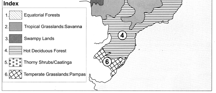
Maharashtra Board Class 8 Science Solutions Chapter 12 Introduction to Acid and Base

Question 3.
State names of any three strong acids.
Answer:

  1. Hydrochloric acid
  2. Sulphuric acid
  3. Nitric acid.

Question 4.
State the names of the acids found in lemon juice, Amla, tamarind water and curd.
Answer:

  1. Lemonuice – citric acid
  2. Amla – ascorbic acid
  3. tamarind water – tartaric acid
  4. curd – lactic acid.

Question 5.
State names of any three alkalis.
Answer:

  1. sodium hydroxide
  2. potassium hydroxide
  3. calcium hydroxide.

Question 6.
State the names of three indicators.
Answer:

  1. Litmus paper
  2. Methyl orange
  3. Phenolphthalein.

Maharashtra Board Class 8 Science Solutions Chapter 12 Introduction to Acid and Base

Question 7.
State the names of three weak alkalis.
Answer:

  1. Calcium hydroxide
  2. ammonium hydroxide
  3. magnesium hydroxide.

Question 8.
From which plant is litmus obtained?
Answer:
Litmus is obtained from plants called lichens.

Question 9.
Name the antacid which is used to control the hyper acidity.
Answer:
Milk of magnesia [Mg(OH)2] is used to control the hyper acidity.

Maharashtra Board Class 8 Science Solutions Chapter 12 Introduction to Acid and Base

Question 10.
How will you neutralize the excess of acid present in the soil?
Answer:
Lime stone or lime water is mixed in the soil to neutralize the excess of acid.

Question 11.
When lemonuice falls on a marble kitchen counter, which is the gas that bubbled out?
Answer:
Carbon dioxide.

Answer the following questions:
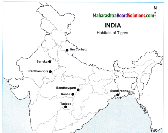
Question 1.
What are indicators?
Answer:
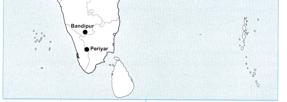
Substances which change their colours in presence of acid or base are called indicators.

Question 2.
State two acid-base indicators and mention their colour change.
Answer:
Phenolphthalein and methyl orange are two acid-base indicators. Phenolphthalein is colourless in an acidic solution while it turns pink in a basic solution. Methyl orange gives orange colour with an acidic solution and yellow colour with a basic solution.

Question 3.
State the colour change for each of the following solutions with red litmus, blue litmus, phenolphthalein and methyl orange solutions.
Answer:
Maharashtra Board Class 8 Science Solutions Chapter 12 Introduction to Acid and Base 5

Question 4.
Name the acid present in (1) Orange (2) Vinegar (3) Tamarind (4) Curd (5) Tomato (6) Lemon.
Answer:

Substance Acid
Orange Citric acid
Vinegar Acetic acid
Tamarind Tartaric acid
Curd Lactic acid
Tomato Oxalic acid
Lemon Citric acid

Maharashtra Board Class 8 Science Solutions Chapter 12 Introduction to Acid and Base

Question 5.
Classify the following into acidic substances, basic substances and salts.
(1) Lime water, (2) soda water, (3) soap water, (4) sea water, (5) sweet limeuice, (6) sugar caneuice, (7) buttermilk, (8) a mixture of ash in water, (9) tamarind water.
Answer:
a. Acidic substances: (1) Soda water, (2) sweet limeuice, (3) buttermilk, (4) tamarind water.
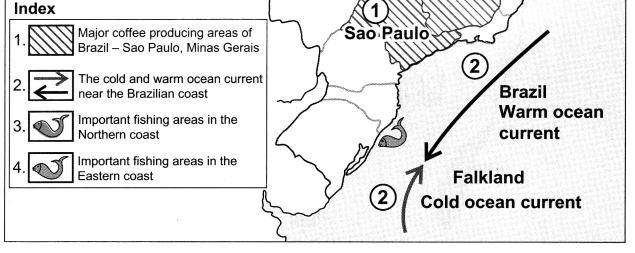
b. Basic substances: (1) Lime water, (2) Soap water, (3) a mixture of ash in water.
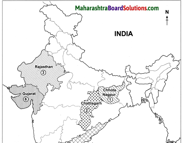
c. Salts: (1) Sea water, (2) sugar caneuice.

Question 6.
What happens when sour substances like limeuice, tamarind water falls on shahabad stones or kitchen platform? Why?
Answer:
When sour substances like limeuice, tamarind water falls on shahabad stones or kitchen platform, citric acid present in limeuice and tartaric acid in tamarind water reacts with metal carbonates present in shahabad stones or kitchen platform, carbon dioxide gas is evolved resulting in the formation of uneven surface.

Question 7.
Collect soil samples from your surroundings and find out whether it is acidic or alkaline or neutral?
Answer:
Soil samples collected from the surroundings are acidic in nature.

Question 8.
Which substances are used to clean greenish stains on copper vessels and to shine blackish silver utensils?
Answer:
Tamarind pulp is used to clean greenish stains on copper vessels. To shine blackish silver utensils, ammoniacal solution or limeuice or detergent is used.

Maharashtra Board Class 8 Science Solutions Chapter 12 Introduction to Acid and Base

Question 9.
Why toothpaste is used for brushing teeth?
Answer:

  1. Toothpaste contains fluorides and alkali to neutralize the mouth acid.
  2. Hence, the tooth paste, which is generally alkaline, is used for cleaning the teeth as it can neutralize the excess acid in i the mouth and prevent tooth decay.

Question 10.
State the properties of acids.
Answer:

  1. Acids are sour in taste.
  2. Acid molecules contain hydrogen ion (H+) as a main constituent.
  3. Acid reacts with metal to form hydrogen gas.
  4. Acid reacts with carbonates and liberates CO2 gas.
  5. Blue litmus turns red in acid.

Question 11.
State the uses of acids.
Answer:

  1. Acids are used in the production s of chemical fertilizers.
  2. Acids are used in the production of explosives, oil purification, medicines, dyes and paints.
  3. Hydrochloric acid is used for the preparation of different types of chloride salts.
  4. Dil. H2SO4 acid is used in the batteries (electric cell).
  5. Dil. HCl is used for sterilization of water.
  6. Acid is used for making of white paper from wood pulp.

Maharashtra Board Class 8 Science Solutions Chapter 12 Introduction to Acid and Base

Question 12.
The iron knife shines better after cutting the sour fruits like lemon, raw mangoes. Why?
Answer:
Acids present in sour fruits clean and dissolves the salts present on the surface of iron knife as a result iron knife shines better after cutting the sour fruits.

Question 13.
What is meant by neutralization? Give example.
Answer:
When an acid reacts with an alkali to form a salt and water, it is called neutralization.
Maharashtra Board Class 8 Science Solutions Chapter 12 Introduction to Acid and Base 6

Give scientific reasons:

Question 1.
When we have stomachache, doctors prescribe medicine containing magnesium hydroxide.
Answer:

  1. There is hydrochloric acid in our stomach which helps in the digestion of food.
  2. Sometimes in the stomach, there is more hydrochloric acid than we need.
  3. This excess acid causes acidity and indigestion resulting in stomachache.
  4. When magnesium hydroxide is administered it neutralizes the extra acid in the stomach.
  5. Therefore, magnesium hydroxide is the best cure for stomachache.
  6. So, when we have stomachache, doctors prescribe medicine containing magnesium hydroxide.

Question 2.
Quicklime or slaked lime is added to the soil.
Answer:

  1. When chemical fertilizers are added to the soil, the soil becomes acidic.
  2. To reduce its acidity quicklime or slaked lime is added to the soil.

Maharashtra Board Class 8 Science Solutions Chapter 12 Introduction to Acid and Base

Question 3.
Tarnished and stained copper vessels are brought to a shine by using tamarind pulp.
Answer:
In due course, unus6d copper vessels
are covered with a coating of black copper oxide and other compounds of copper which tarnish the vessel. Tamarind contains tartaric acid. When the vessel is rubbed with tamarind pulp, tartaric acid reacts with copper oxide and removes the layer. Thus, the copper vessel regains its shine.

Question 4.
Copper and brass utensils are tinned.
Answer:
Copper and brass reacts with i organic acids present in food materials and poisonous salts are formed. Tin does not react with organic acids present in food materials. Therefore, copper or brass vessels are tinned.

Distinguish between acid and alkali. OR Distinguish between the following:

Question 1.
Acid and Alkali:
Answer:

Acid Alkali
1. Acid has sour taste. 1. Alkali has bitter taste.
2. Acid turns blue litmus red. 2. Alkali turns red litmus blue.
3. An acid in an aqueous solution gives H+ ions. 3. An alkali in an aqueous solution gives OH+ ions.
4. Oxides of non – metals form acids. 4. Oxides of metals form bases.

Maharashtra Board Class 8 Science Solutions Chapter 12 Introduction to Acid and Base

Activity-based questions:

Activity 1:
Apparatus: Hibiscus, rose, turmeric, red cabbage leaves, filter paper, etc.
Activity: Rub red petals of hibiscus flower on the white filter paper. This gives hibiscus indicator paper. Similarly rub, rose petals on the white filter paper. Cut strips of this paper, it is a rose indicator paper. Take turmeric powder, add a little water in it. Dip filter paper or ordinary paper in the turmeric water for some time.

After drying make strips of that paper. Prepare turmeric indicator paper in this way. Put leaves of red cabbage in small quantity of water and heat it. Once solution of cabbage leaves cool down, dip papers in it and dry it. Make strips of dried paper. In this way prepare red cabbage indicator paper. Put some drops of following substances on the indicator papers prepared by the above method and write the effect in the following table:

Substance Effect on turmeric paper Acidic/basic
1. Lime juice Yellow Acidic
2. Lime water (calcium hydroxide) Red Basic
3.

Maharashtra Board Class 8 Science Solutions Chapter 12 Introduction to Acid and Base

Activity 2:
Take baking powder. Add a little water to it. Add this solution on to limeuice, vinegar, orangeuice, appleuice, etc. and note the findings.
What do you observe on addition of baking soda solution in the fruituice? Whether bubbles formed or effervescence came out of fruituice?
From the above first activity we came to know that yellow turmeric indicator paper’s turns red in certain solutions. Similarly on addition of baking soda solution in the acidic solution bubbles come out or effervescence is produced.
By these simple and easy activity we can identify acidic or alkaline substance:
[Note for Activity 1 and Activity 2: Students should perform the experiments under the guidance of school teachers and record their observations.]

Maharashtra Board Class 8 Science Solutions Chapter 12 Introduction to Acid and Base

Activity 3:
Under the guidance of teacher take limeuice, ammonium hydroxide (NH4OH), dil. hydrochloric acid (dil. HCl) and nitric acid (HNOs) in different test-tubes. Add drops of following indicators in them. Also dip litmus papers in the solutions. Observe and record in the following table.
Maharashtra Board Class 8 Science Solutions Chapter 12 Introduction to Acid and Base 7

8th Std Science Questions And Answers: