Balbharti Maharashtra State Board Class 11 Geography Important Questions Chapter 1 Earth Movements Important Questions and Answers.
Maharashtra State Board 11th Geography Important Questions Chapter 1 Earth Movements
Complete the chain.
Question 1.
| A | B | C |
| (1) P-waves | (1) Ring of Fire | (1) Indonesia |
| (2) Volcanic eruption | (2) Shadow zone | (2) Italy |
| (3) Cinder cone | (3) Smoke | (3) Cauliflower cloud |
| (4) Tectonic movements | (4) Mt. Nuovo | (4) Cotopaxi |
| (5) Circum pacific belt | (5) Convergent and divergent margin | (5) Between 105° and 140° |
Answer:
| A | B | C |
| (1) P-waves | (1) Shadow zone | (1) Between 105° and 140° |
| (2) Volcanic eruption | (2) Smoke | (2) Cauliflower cloud |
| (3) Cinder cone | (3) Mt. Nuovo | (3) Italy |
| (4) Tectonic movements | (4) Convergent and divergent margin | (4) Indonesia |
| (5) Circum pacific belt | (5) Ring of Fire | (5) Cotopaxi |
![]()
Choose the correct option by identifying the correct correlation in the sentences.
Question 1.
Formation of mountains and distribution of continents are related to ……………
(a) sudden movements
(b) slow movements
(c) vertical movements
(d) horizontal movements
Answer:
(b) slow movements
Question 2.
A fold where one limb lies over the other in horizontal direction is ………………
(a) symmetrical fold
(b) overturned fold
(c) recumbent fold
(d) isoclinal fold
Answer:
(c) recumbent fold
Question 3.
Young fold mountains are of ………………… age.
(a) 10 to 25 million years
(b) over 200 million years
(c) 25 to 40 million years
(d) 30 to 45 million years
Answer:
(a) 10 to 25 million years
Question 4.
The tensional forces may cause subsidence in the central portion of the crust between two adjacent faults forming …………………
(a) rift valleys
(b) lava domes
(c) fold mountain
(d) volcanic mountain
Answer:
(a) rift valleys
Question 5.
P-waves can pass through ………………….
(a) only solid medium
(b) only liquid medium
(c) all mediums
(d) air
Answer:
(c) all mediums
Question 6.
When the lava solidifies in the volcanic neck, it forms …………….
(a) caldera
(b) cinder cone
(c) crater
(d) volcanic plug
Answer:
(d) volcanic plug
![]()
Question 7.
When a portion of landslides down along the fault plane and when the exposed portion of the plane faces the sky ………….. is formed.
(a) reverse fault
(b) normal fault
(c) thrust fault
(d) tear fault
Answer:
(b) normal fault
Question 8.
Faulting results in the formation of ……………….
(a) volcanic mountains
(b) block mountains
(c) fold mountains
(d) volcanic plateaus
Answer:
(b) block mountains
Question 9.
A specific area where the seismic waves are not reported is called a ……………….
(a) shadow zone
(b) epicentre
(c) focus
(d) fracture zone
Answer:
(a) shadow zone
Question 10.
The describes the intensity of an earthquake based on its observed effects.
(a) Richter scale
(b) Mercalli scale
(c) seismogram
(d) seismograph
Answer:
(b) Mercalli scale
Question 11.
Sometimes, the lava material thrown into the air solidifies into small fragments before falling on the surface; it is called ………………
(a) crock fragments
(b) ash
(c) volcanic dust
(d) volcanic bombs
Answer:
(d) volcanic bombs
Question 12.
The …………….. are symmetrical in shape.
(a) cinder cone
(b) lava domes
(c) volcanic plateau
(d) composite cone
Answer:
(d) composite cone
Question 13.
Earthquakes are recorded with the help of ………………. instrument.
(a) seismogram
(b) seismograph
(c) Richter scale
(d) Mercalli scale
Answer:
(b) seismograph
![]()
Identify the correct correlation.
Question 1.
A – The origin of Himalayas is due to the collision of the Indian subcontinent with Eurasian landmass.
R – The convergence of plates is often associated with mountain building.
(a) Only A is correct.
(b) Only R is correct.
(c) Both A and R are correct and R is the correct explanation of A.
(d) Both A and R are correct but R is not the correct explanation of A.
Answer:
(c) Both A and R are correct and R is the correct explanation of A.
Question 2.
A – The structure of the interior of the earth is decided with the help of seismic waves.
R – The S-waves travel in solid, liquid and gaseous medium while P-waves travel only through solid medium.
(a) Only A is correct.
(b) Only R is correct.
(c) Both A and R are correct and R is the correct explanation of A.
(d) Both A and R are correct but R is not the correct explanation of A.
Answer:
(a) Only A is correct.
Question 3.
A – Volcanic activity coincides with seismic activity of the world.
R – The seismic cone coincides with plate boundaries.
(a) Only A is correct.
(b) Only R is correct.
(c) Both A and R are correct and R is the correct explanation of A.
(d) Both A and R are correct but R is not the correct explanation of A.
Answer:
(d) Both A and R are correct but R is not the correct explanation of A.
Question 4.
A – Basic lava contains less percentage of silica.
R – It has high melting point.
(a) Only A is correct.
(b) Only R is correct.
(c) Both A and R are correct and R is the correct explanation of A.
(d) Both A and R are correct but R is not the correct explanation of A.
Answer:
(a) Only A is correct.
Identify the incorrect factor.
Question 1.
The types of fold are-
(a) symmetrical
(b) recumbent
(c) Isoclinal
(d) Reverse
Answer:
(d) Reverse
![]()
Question 2.
The types of fault are-
(a) overturned
(b) reverse
(c) Thrust
(d) Tear
Answer:
(a) overturned
Question 3.
Causes of earthquake are-
(a) tectonic movements
(b) anthropogenic causes
(c) landslides
(d) Volcanicity
Answer:
(c) landslides
Question 4.
The solid material thro wn out of volcano consists of-
(a) soil
(b) volcanic bomb
(c) breccias
(d) Ash
Answer:
(a) soil
Question 5.
The material thrown out in formation of cinder cone are-
(a) ash
(b) cinder
(c) breccias
(d) Dust
Answer:
(d) Dust
Question 6.
Three major belts of earthquake and volcanoes are-
(a) Mid-Atlantic belt
(b) Mid-continental belt
(c) Circum-Pacific belt
(d) Indian Ocean belt
Answer:
(d) Indian Ocean belt
Question 7.
Three types of seismic waves are-
(a) P-waves
(b) S-waves
(c) F-waves
(d) longitudinal waves
Answer:
(c) F-waves
Question 8.
Examples of block mountain are-
(a) Black Forest Mountains in Germany
(b) Satpuras in Maharashtra
(c) Vosges in France
(d) Himalayas in India
Answer:
(d) Himalayas in India
Identify the correct group.
Question 1.
| A | B | C | D |
| (1) Mt. Fujiyama | (1) Normal Fault | (1) Rock Fragments | (1) Crater Lake |
| (2) Mt. St. Helens | (2) Reverse Fault | (2) Volcanic Dust | (2) Caldera |
| (3) Pinatubo | (3) Tear Fault | (3) Inflammable gases | (3) Volcanic Plug |
| (4) Mayon | (4) Overturned fold | (4) Biotic Material | (4) Volcanic Plateau |
Answer:
C
Question 2.
| A | B | C | D |
| (1) Asymmetrical Fold | (1) Normal Fault | (1) Zone I – Very high intensity | (1) Limb |
| (2) Overturned Fold | (2) Thrust Fault | (2) Zone II – High intensity | (2) Anticline |
| (3) Isoseismal Lines | (3) Reverse Fault | (3) Zone III – Moderate intensity | (3) Syncline |
| (4) Symmetrical Folds | (4) Tear Fault | (4) Zone IV – Low intensity | (4) Trough |
Answer:
C
![]()
Give geographical reasons.
Question 1.
Faulting results in formation of block mountains.
Answer:
Faulting results in formation of block mountains because-
- Earth movements generate tensional forces that tend to pull the crust apart and faults are developed.
- If the block enclosed by the faults rises above or the land on either side subsides, the upstanding portion becomes the block mountain.
- The Black forest mountain in Germany, Vosges in France, Satpuras in Maharashtra are examples of block mountains.
Question 2.
The crust of the earth shakes.
Answer:
The crust of the earth shakes because –
- Movements occurring in the crust of the earth produce a lot of stress in the rock strata.
- When this stress accumulates beyond a limit, it tends to get released in the crust.
- Release of stress causes release of energy.
- The release of energy produces energy waves and this makes the earth’s crust to shake.
Question 3.
A zone between 105° and 140° from the epicentre is identified as the shadow zone for P and S waves.
Answer:
A zone between 105° and 140° from the epicentre is identified as the shadow zone for P and S waves because-
- Generally, seismographs located at any distance within 105° from the epicentre, record the arrival of both P-waves and S-waves.
- However, the seismographs located beyond 140° from the epicentre; record the arrival of P-waves but not that of S-waves.
- The shadow zone results from S-waves being stopped entirely by the liquid core and P-waves being bent (refracted) by the liquid core.
Question 4.
Volcanic eruptions can cause earthquakes.
Answer:
Volcanic eruptions can cause earthquakes because-
- Most of the earthquakes are along the edges of tectonic plates. This is where most volcanoes are too.
- Most earthquakes directly beneath a volcano are caused by the movement of magma.
- The magma exerts pressure on the rocks until it cracks the rock.
- Then the magma flows out into the cracks building pressure again. Every time the rock cracks it makes a small earthquake.
![]()
Question 5.
Most of the volcanoes are found along plate boundaries.
Answer:
Most of the volcanoes are found along plate boundaries because-
- Volcanoes are common along convergent and divergent plate boundaries.
- They are also associated with meeting zones of continents and oceans.
- Volcanoes erupt because mantle rock melts, due to extremely high temperatures, and pressure.
- Along the subduction plate boundaries, the crust heats up as it sinks into the mantle, resulting into upwelling of lava.
Differentiate between.
Question 1.
Volcanoes and Earthquakes.
Answer:
| Volcanoes | Earthquakes |
| (i) Volcanoes form at the earth’s surface. | (i) Earthquakes originate from deeper within the crust. |
| (ii) Volcanoes are formed by release of gases and magma. | (ii) Earthquakes are caused by movement along a fault. |
| (iii) Volcanoes lead to formation of new landforms like domes, plateaus, cones, caldera etc | (iii) Earthquakes simply cause waves which disturb rocks they do not form any landforms. |
| (iv) It directly produces ash and other volcanic debris. | (iv) Earthquake events does not directly produce debris. But debris results by destruction due to the earthquake. |
| (v) It is possible to predict a volcanic eruption a few weeks to a few days in advance, though the exact time of eruption can’t be predicted with any accuracy. | (v) The likelihood of an earthquake can be predicted but it is not possible to determine any time frame of when the earthquake will take place, or how likely it is to happen at some point in future. |
Question 2.
Acid lava and Basic lava.
Answer:
| Acid lava | Basic lava |
| (i) It contains high percentage of silica. | (i) It contains less percentage of silica. |
| (ii) It has got high melting point. | (ii) It has low melting point. |
| (iii) It is thick, fluid and moves slowly. | (iii) It is more fluid and can flow over long distance. |
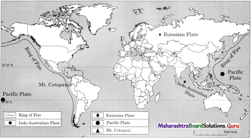
Mark and name the following on the outline map of the world with suitable index.
(1) Ring of Fire
(2) Indo-Australian plate
(3) Eurasian Plate
(4) Pacific Plate
(5) Mt. Cotopaxi
Answer:
Answer the following Questions by using the given map
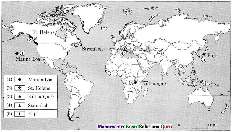
Question 1.
Name the volcanic mountain in Africa.
Answer:
Kilimanjaro
Question 2.
Name the volcanic mountain in Pacific Ocean.
Answer:
Mauna Loa
Question 3.
Name the volcanic mountain in Japan.
Answer:
Fuji
Question 4.
Name volcanic mountain in Europe.
Answer:
Stromboli
![]()
Question 5.
Name the volcanic mountain along the north eastern coastline of North America.
Answer:
St. Helens
Write short notes on.
Question 1.
Folding
Answer:
- Folding occurs when compressional forces are applied to rocks that are ductile or flexible.
- Rocks that lie deep within the crust and are therefore under high pressure are generally ductile and particularly susceptible to folding without breaking.
- As a result, rocks deep within the crust typically fold rather than break.
- Folding is also likely to occurs where compressional forces are applied slowly.
- Folding results into formation of fold mountains e.g., the Himalayas, the Alps etc.
- There are different parts of folds – limbs, axis of fold, Anticline, syncline, axial plane.
- There are different types of fold formed on basis of inclination of limbs – symmetrical fold, asymmetrical fold, overturned fold, recumbent fold and isoclinal fold.
- The nature of fold depends on several factors like, the nature of rocks, the nature and intensity of compressive forces, duration of the operation of compressive forces, etc.
Question 2.
Faulting:
Answer:
- In the earth’s crust, the forces operating in opposite direction lead to tension.
- As a result, rocks develop cracks or fissure.
- In the regions where cracks develop rocks get displaced, such displacement can occur in upward downward or horizontal direction.
- Faulting can be classified according to displacement of rocks.
- Rock layers that are near the earth’s surface and not under high confining pressures are too rigid to bend into folds.
- If the tectonics force is large enough, these rocks will break rather than bend. Such breaks may also be called fracture, ruptures or faults.
- Faulting results in formation of block mountains and rift valleys.
- There are different types of faults – normal faults, reverse faults, tear fault and thrust fault.
Question 3.
Types of faults
Answer:
A fault is a fracture in the crustal rock, formed when the crustal rocks are displaced due to tensional movement caused by endogenic forces. The displacement of rock can occur in upward, downward different or horizontal direction.
The types of faults determined by the direction of motion are:
- Normal fault: It results when portion of land slides down along the fault plane and when the exposed portion of the plane faces the sky.
- Reverse fault: It results when a portion of the land is thrown upward relative to other side of the land. In such situation, the fault plane faces the ground.
- Tear fault : At times, the rock strata on either side of the fault plane do not have vertical displacement. Instead, movement occurs along the plane in horizontal direction.
- Thrust fault: When the portion of the land on one side of the fault plane gets detached and moves over the land on the other side. The angle of fault plane is generally less than 45°.
Question 4.
Types of folds
Answer:
Folding occurs when compressional forces are applied to rocks, that are ductile or flexible.
The different types of folds are:
Symmetrical folds:
- The axial plane is vertical.
- The limbs are inclined at the same angle.
Asymmetrical folds:
- The axial plane is inclined.
- The limbs are inclined at different angles.
Overturned fold:
- One limb lies above the other limb.
- Limbs slope unequally in the same direction.
Recumbent fold:
- Axial plane is almost horizontal.
- One limb lies over the other in horizontal direction.
Isoclinal fold:
- The limbs slope in the same direction with same amount.
- The axial plane may be vertical, inclined or horizontal.
- Slope of some portion of limbs is near vertical.
![]()
Question 5.
Volcanic landforms
Answer:
A number of landforms are formed due to cooling and solidification of magma. Some important landforms are as follows :
Lava Domes :
- Domes are developed when magma comes out and solidifies around its mouth.
- The shape of the dome depends upon the fluidity of lava.
- High dome with steep slope is developed by acidic lava.
- Due to basic lava, broad-based low domes are developed.
Lava Plateaus:
- Due to spread of lava in huge quantity from fissure volcano, it covers large areas and plateaus are formed.
- The Deccan Trap in India has developed from volcanic eruptions millions of years ago.
Caldera:
- At times, the eruption of volcano brings about large quantity of material and relieves lot of pressure.
- After the eruption, a large and deep depression remains in that area. This large depression is called caldera.
- These can be around 10 km wide and hundreds of metres deep.
- They may later turn into lakes. Smaller calderas are known as craters.
Crater Lake:
- When the funnel shaped crater of an extinct volcano gets filled with rain water, it forms a crater lake.
Volcanic Plug:
- It is formed when the lava solidifies in the volcanic neck.
- The surrounding rock material is removed by different agents of erosion; the vent stands predominantly. It is called as volcanic plug.
- The diameter of a plug varies between 300 and 600 metres.
- The Devil’s Tower in Wyoming, United State of America is the best example.
Cinder Cone:
- Solid material is ejected in large quantity.
- This material consists of ash, cinder and breccias.
- Cinders are half burnt pieces of solid material.
- The solid material is deposited around the mouth until a conical hill with steep slopes is formed.
- For example, cone of Mt. Nuovo in Italy.
Composite Cone:
- Composite cones are built up of alternate layers of lava and cinder.
- This cone is composed of two materials and therefore it is called a composite cone.
- It is symmetrical in shape.
- For example, Mt. St. Helens, USA.
Question 6.
Volcanic Materials
Answer:
There are three main types of material which come out in volcanic eruptions namely liquid, solid and gaseous form.
Liquid material:
- It is the molten rock material. When the molten rock material is below the earth’s surface, it is called ‘Magma’.
- When it appears on the surface it is called ‘lava’. On the basic of percentage of silica, it is classified as:
Acidic lava:
- It contains higher percentage of silica.
- It has high melting point.
- It is thick, fluid and moves slowly.
Basic lava:
- It contains less percentage of silica.
- It has low melting point.
- It’s thicker, fluid and can flow over longer distance.
Solid material:
- It consists of dust particles and rock fragments.
- When the material is very fine, it is called volcanic dust.
- The small sized solid particles are called ash.
- The solid angular fragments are known breccias.
- Sometimes, the lava material thrown into the air solidifies into small fragments before falling on the earth’s surface; it is called volcanic bombs.
Gaseous material:
- At the time of volcanic eruption, a dark cloud of smoke can be seen over the crater.
- On the basis of shape, cloud is called cauliflower cloud.
- Various inflammable gases are found in these clouds.
- These gases produce flames.
Question 7.
Shadow Cone
Answer:
- The waves which are caused by earthquake are called seismic waves. There are three types of waves: P-waves, S-waves and longitudinal waves.
- P- waves can pass through all the mediums while S-waves can pass only through solid medium.
- Even though P-waves pass through all mediums, they experience refraction as they pass from one medium to the other.
- However, there exist some specific areas where the waves of that earthquake are not reported. Such zones are called ‘shadow zones’.
- Generally, seismographs located at any distance within 105° from the epicentre, record both P-waves and S-waves. However, beyond 140° P-waves are recorded but not S-waves.
- Thus, the zone between 105° and 140° is identified as the shadow zone for both types of waves.
- The entire zone beyond 105° does not receive S-waves. The shadow zone of S-waves is much larger than that of P-waves.
- The shadow zone of P-waves appears as a band around the earth between 105° and 140° away from the epicentre.
Draw a neat and labelled diagram for
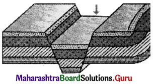
Question 1.
Parts of fold
Answer:
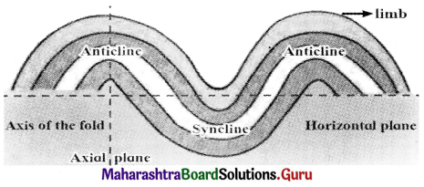
![]()
Question 2.
Block Mountain
Answer:
Question 3.
Rift Valley
Answer:
Answer in detail.
Question 1.
Give the distribution of earthquakes and volcanic belts in the world.
Answer:
There are three major belts or zones of earthquakes and volcanoes on the earth.
Circum-Pacific belt:
- This belt is also called as ‘Ring of Fire’ as it has maximum number of active volcanoes.
- It includes the volcanoes of eastern and western coastal areas of the Pacific Ocean.
- This belt contains most of the world-famous volcanic mountains and volcanic cones.
- The highest volcanic mountain of the world Cotopaxi is located in this belt.
- Fujiyama (Japan) Mt. St. Helens (Washington, USA) Pinatubo and Mayon (Philippines) are other significant volcanoes in this belt.
Mid-Atlantic belt:
- This belt covers the volcanoes mainly along the Mid-Atlantic ridge.
- The most active volcanic area in Mid-Atlantic ridge is Iceland.
Mid-Continental belt:
- This belt includes the volcanoes of Alpine mountain chains, the Mediterranean Sea and volcanoes of fault zone of Eastern Africa.
- The famous volcanoes in this belt are Stromboli and Mt. Etna.
Question 2.
Explain different types of folds.
Answer:
Folding occurs when compressional forces are applied to rocks which are ductile or flexible. The different types of folds are.
Symmetrical folds:
- The axial plane is vertical.
- The limbs are inclined at the same angle.
Asymmetrical folds:
- The axial plane is inclined.
- The limbs are inclined at different angles.
Overturned fold:
- One limb lies above the other limb.
- Limbs slope unequally in the same direction.
Recumbent fold:
- One Axial plane is almost horizontal.
- One limb lies over the other in horizontal direction.
Isoclinal fold:
- The limbs slope in the same direction with same amount.
- The axial plane may be vertical, inclined or horizontal.
- Slope of some portion of limbs is near vertical.
![]()
Question 3.
Explain different types of slow movements.
Answer:
Slow movement can be classified as:
Vertical or Epeirogenic Movements:
- Slow movements keep on taking place either towards the centre of the earth or away from it towards the crust.
- Due to such movements, an extensive portion of the crust is either raised up or it subsides.
- When a portion of the crust is raised up above sea level, it leads to formation of continents. Hence, they are also called ‘continent-building movements.’
- Such movement can also form extensive plateaus.
- These movements are not related to development of tensions or pressure in the earth’s crust.
Horizontal or Orogenic Movements:
- These movements work in horizontal direction.
- These movements produce compression or tension in the rock strata.
- These movements lead to either folds or cracks in the surface of the earth. These movements give rise to mountains.
- Their speed is more than ‘continental-building’ movements.
- These movements either produce folds or faults. Consequently, either fold mountains or block mountains are formed.